Deeper Look Into The Long Range…
You must be logged in to view this content. Click Here to become a member of IndyWX.com for full access. Already a member of IndyWx.com All-Access? Log-in here.
You must be logged in to view this content. Click Here to become a member of IndyWX.com for full access. Already a member of IndyWx.com All-Access? Log-in here.
 Highlights:
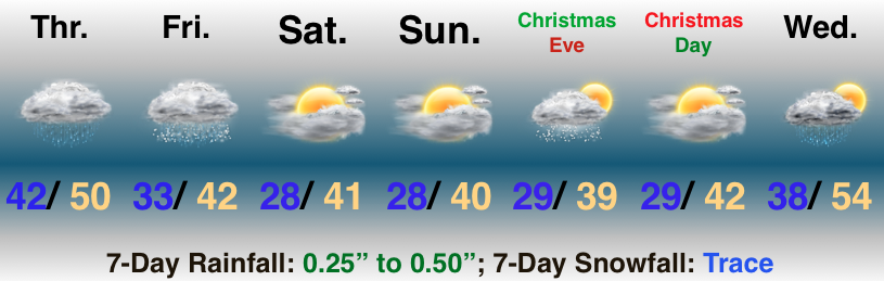
Milder Than Normal, But Damp At Times…A storm system will deliver periods of light rain to central Indiana today into the wee morning hours Friday. Steadiest rain will fall to our east, but we will notice greater overall coverage of rain this evening into the overnight period. As colder air wraps in here late tonight and Friday morning, precipitation will end as light snow (no accumulation is expected).
The weekend will feature quiet conditions and our attention will shift to the potential for a weak weather system to scoot through here on Christmas Eve. With just enough cold air in place, precipitation would likely fall as light snow. Again, this isn’t expected to be a big deal, but we’ll remain hopeful for a “touch” of snow as Santa gets set for his big night.
Dry conditions return on Christmas Day and temperatures will begin to moderate ahead of a big wet storm system that will arrive the middle of next week.
While we’re tracking multiple weather makers between now and Christmas, there doesn’t appear to be any sort of major storm(s) on the horizon.
You must be logged in to view this content. Click Here to become a member of IndyWX.com for full access. Already a member of IndyWx.com All-Access? Log-in here.
 Highlights:
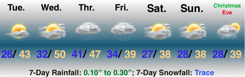
Soak Up That Vitamin D…High pressure will remain in control of our weather and present quiet conditions with plentiful sunshine as we move through the next couple of days. Enjoy! Temperatures will also be on the uptick- flirting with, or exceeding, the 50° mark Wednesday.
Our next storm system will deal areas east of IN the worst of conditions from a wind, rain, and eventually snow standpoint, but we will get in on light rain and blustery conditions to close the work week. A couple of snowflakes may mix in with the precipitation before ending Friday.
Seasonably chilly and dry conditions return over the weekend before a weak weather system zips through here on Christmas Eve with a couple of light snow showers. Looking ahead, high pressure should lead to a return of sunshine with low-mid 40s on Christmas Day.
You must be logged in to view this content. Click Here to become a member of IndyWX.com for full access. Already a member of IndyWx.com All-Access? Log-in here.