Category: Unseasonably Warm

Overall Dry And Pleasant Weather Continues…

Highlights:

  • Scattered late-day storms Sunday
  • Dry weather returns
  • Cooler next week

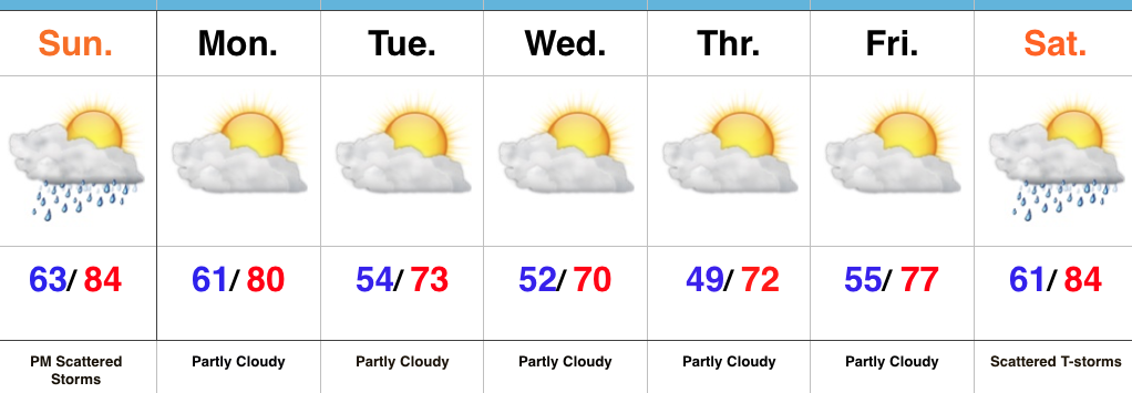
Scattered Strong Storms Late Sunday…Our beautiful weekend weather will continue into Sunday.  Expect a mostly dry day along with warm and humid conditions.  A cold front will approach late in the day and we still think a broken line of thunderstorms will slip south into central Indiana Sunday evening into Sunday night.  A couple of these could become strong, but a widespread severe weather event isn’t anticipated.

We’ll quickly get back to dry conditions as we open the new work week and another extended spell of rain-free conditions should carry us through the balance of the upcoming forecast period.  Additionally, a notable cooling trend will engulf the region.  With dry skies, low humidity, and highs in the lower 70s it’ll be picture-perfect to spend time outdoors.

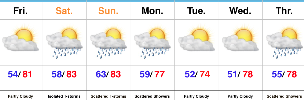
Moisture will begin to return next weekend and, accordingly, we’ll introduce scattered showers and thunderstorms into our forecast next Saturday.

Upcoming 7-Day Precipitation Forecast:

  • Snowfall: 0.00″
  • Rainfall: 0.25″ – 0.50″

Permanent link to this article: https://indywx.com/overall-dry-and-pleasant-weather-continues/

Drier Trend Continues This Weekend…

Highlights:

  • Dry close to the work week
  • Mostly dry weekend
  • Slightly cooler next week

Models Continue To Trend Drier…It was only a couple days ago that models were suggesting the threat of heavy rain and scattered strong storms this weekend- beginning Friday.  In this business, it doesn’t take long for things to change sometimes, but this is the first legitimate change for the “drier” that we’ve seen with storm systems since winter.  Time and time again as we draw closer to events, modeling has had to play “catch up” for the wetter over the past few months.

The end result is one that will feature a mostly dry weekend, including only isolated storm coverage Saturday afternoon and evening (most stay dry) and scattered coverage Sunday.  As a whole, many more dry hours are expected this weekend than stormy.

The other big takeaway over the past few days is the cool bias models have had.  This is noted and documented and we’re adjusting our forecast accordingly moving forward.  Drier and cooler air will arrive after Monday showers, but temperatures won’t run nearly as cool as once projected.  For the second week in a row, very pleasant and refreshing weather is ahead for the middle of the week.  Not bad, at all, by June standards.

Upcoming 7-Day Precipitation Forecast:

  • Snowfall: 0.00″
  • Rainfall: 0.50″ – 0.75″

Permanent link to this article: https://indywx.com/drier-trend-continues-this-weekend/

JMA Weeklies: Cool Gives Way To More Seasonal Conditions…

The new JMA Weeklies are in and the highlights include:

  • Unseasonably cool conditions Week 1
  • Anomalously wet across the Southeast
  • Warmer, more seasonal early-summer weather arrives

Week 1:

The pattern is dominated by an eastern trough and western ridge. Accordingly, cooler than average conditions will dominate the central and eastern portions of the country.  Very wet conditions should dominate the southern and eastern tier of the country (heaviest rains should fall east and south of Indiana).

Week 2:

The pattern begins to “relax” a bit, locally, with warmer conditions set to develop.  We note three areas of anomalously wet weather- west coast, northern Plains and Southeast.

Weeks 3-4

While the pattern doesn’t seem to promote any sort of significant heat or cool (relative to normal), this is certainly a warmer look, overall, to close the month than how we’re starting.  This look would suggest warm, seasonal, summer conditions locally with average precipitation.  Wet weather continues to dominate the pattern across the south and begins to emerge into the central.

Permanent link to this article: https://indywx.com/jma-weeklies-cool-gives-way-to-more-seasonal-conditions/

VIDEO: Unsettled Weather Returns For Midweek And Looking Ahead To Race Day Weather…

You must be logged in to view this content. Click Here to become a member of IndyWX.com for full access.  Already a member of IndyWx.com All-Access?  Log-in here.

Permanent link to this article: https://indywx.com/video-unsettled-weather-returns-for-midweek-and-looking-ahead-to-race-day-weather/

Busy Week Of Weather…

Highlights:

  • Sunny open to the work week
  • Midweek storms
  • Storm chances remain for the long race and holiday weekend ahead

Pleasant Open To The Work Week…High pressure will support dry and pleasant weather conditions as we open up the work week. Expect plentiful sunshine and comfortable conditions to spend time outdoors today!  Enjoy!

Unsettled weather will return for midweek as low pressure moves into the Ohio Valley.  Scattered showers Tuesday will increase in overall coverage and intensity Wednesday, including the potential of locally heavy rainfall.  With all of the clouds and rain around through midweek, temperatures will run significantly below average.

Thankfully, we’ll get a breather Friday, with a mostly dry day expected.  We’ll turn the temperature up a couple notches heading into the long race and Memorial Day weekend.  Additionally, expect an increasingly muggy feel with scattered thunderstorms returning to the forecast this weekend.

Upcoming 7-Day Precipitation Forecast:

  • Snowfall: 0.00″
  • Rainfall:  1.50″ – 2.00″

Permanent link to this article: https://indywx.com/busy-week-of-weather/