
 Highlights:
- Brief midweek thaw
- Late week winter storm threat
- Much colder air returns
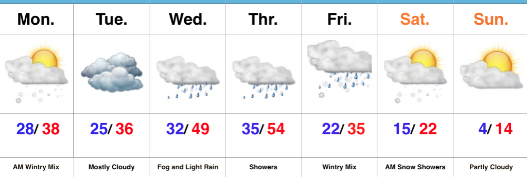
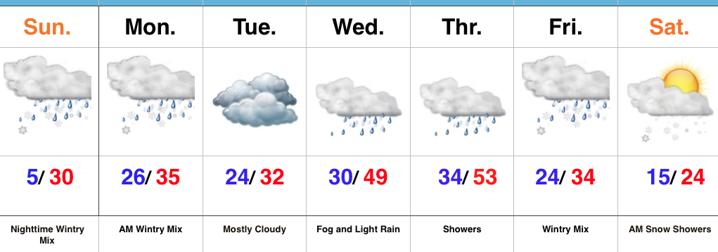
Take It Slow This Morning…An overnight mixture of sleet, freezing rain, and snow has created a few slick spots, but widespread travel issues haven’t been reported this morning. Thankfully, even a 1° to 2° difference (milder) in surface temperatures overnight helped us out in that regard. The wintry mix is heading out and we should even see a little sunshine later today.
As temperatures settle back below freezing tonight, concern is present for the possibility of freezing fog and freezing drizzle in spots into Tuesday morning. A warm front will then lift north through the state Wednesday helping our brief midweek “thaw” get underway in earnest. Showers will accompany the milder conditions into Thursday.
A cold front will settle south through the state Thursday night and colder air will press southeast. At the same time, a secondary area of low pressure will develop along the tail end of the front and lift northeast into the Ohio Valley Friday evening into early Saturday. While this has the sure sign to be a significant, impactful winter storm, we’re obviously still a couple days away from being able to nail down precise track and strength. Stay tuned and keep close tabs on that Friday-Saturday forecast. We’ll turn much colder once again over the weekend.
Upcoming 7-Day Precipitation Forecast:
- Snowfall: 2″ to 4″
- Rainfall: 0.50″ to 0.75″
 Highlights:
 Highlights: