Category: Unseasonably Warm

Active Week Ahead…

Sun.

Mon.

Tue.

Wed.

Thr.

Fri.

Sat.

 Status-weather-showers-day-icon

 Status-weather-showers-day-icon

 Status-weather-showers-day-icon

 Status-weather-showers-day-icon

 Status-weather-showers-day-icon

 Status-weather-showers-day-icon

 Status-weather-showers-day-icon

67/ 79

67/ 81

69/ 85

68/ 87

69/ 88

70/ 88

71/ 89 

More Like Summer…The upper air pattern this week will be unlike what we’ve seen the majority of the summer.  A ridge of high pressure will expand across the southeast region and build northwest.  Meanwhile, a trough and associated cooler air mass will impact the northern Rockies and northwest region.

Low pressure will dominate our sensible weather today with lots of clouds and widespread rain downstate.  Scattered showers and thunderstorms will impact central portions of the state.  As we progress into the work week, we’ll have to remain on our toes for thunderstorm complexes that may ride the periphery of the expanding hot dome to our south.  This will keep things rather active and unsettled through the forecast period.

The other topic of interest will be our temperatures. Whether we crack the official 90 degree mark or not is yet to be seen, but it’ll certainly feel very hot and humid around these parts through the week, especially the back half of the week.  “Air you can wear” will be the weather theme this week.

7-Day Precipitation Forecast:

  • 7-Day Rainfall Forecast: 1.50″-2.00″
  • 7-Day Snowfall Forecast: 0.00″
Cool shifts northwest this week while heat builds across the south and central.

Cool shifts northwest this week while heat builds across the south and central.


Permanent link to this article: https://indywx.com/2014/08/17/active-week-ahead/

Talking Heat, Humidity, And Rain…

Happy Saturday afternoon to all!  This evening’s video covers what continues to look like an active weather pattern, including multiple rain chances ahead for the upcoming week.  We also discuss the upper air pattern and the expanding area of heat.

UAPattern822824

Permanent link to this article: https://indywx.com/2014/08/16/talking-heat-humidity-and-rain/

JAMSTEC Take On Upcoming Fall/ Winter

With each passing day our thoughts turn more and more towards the upcoming busy fall and winter months ahead.   Among the vast array of data to sort through, we wanted to show you the latest JAMSTEC (Japan Agency For Marine-Earth-Science And Technology) take on the upcoming fall and winter.  Admittedly, we’re still a ways off from being able to tell you with any sort of certainty what the upcoming winter holds in store, as far as the “concrete details” go.  That said, thinking, at least here, remains on the side of the camp that believes another colder/ snowier than normal winter lies ahead for our region.

As far as the fall goes, we’re likely to see a predominant southeast ridge dominate the pattern, with more of a “back and forth” fight across our immediate neck of the woods.  In some ways, we’re beginning to see this type reflection in the pattern this week.

In any event, the latest JAMSTEC fall (Sept-Nov) idea as far as temperature anomalies go:

temp2.glob.SON2014.1aug2014

Note the southeast ridge should keep the south-central and south-east (on up along the eastern seaboard) a touch warmer than average.  The center of the cool will back west for a time to include the Rockies, N Plains, and northern Lakes.  Again, more of a back and forth fight here, and quite active!

Before we close, as stated above, we think another cold, snowy winter lies ahead for our area.  The JAMSTEC remains bullish on another cold winter (Dec-Feb) for the 3rd month in a row:

temp2.glob.DJF2015.1aug2014

Permanent link to this article: https://indywx.com/2014/08/16/jamstec-take-on-upcoming-fall-winter/

Crisp, Chilly Start…

Fri.

Sat.

Sun.

Mon.

Tue.

Wed.

Thr.

 Status-weather-clouds-icon

 Status-weather-showers-day-icon

 Status-weather-showers-day-icon

 Status-weather-showers-day-icon

 Status-weather-showers-day-icon

 Status-weather-showers-day-icon

 Status-weather-showers-day-icon

48/ 77

58/ 80

66/ 80

68/ 81

63/ 84

67/ 88

70/ 89 

Perfect Close To The Work Week…Canadian high pressure will remain in control of our weather to wrap up the work week and supply dry skies and unseasonably cool temperatures.  The cool, crisp, autumn like start to the day (most are awaking to temperatures in the 40s) will only warm into the upper 70s this afternoon with lots of sunshine.

Unsettled; More Humid…Multiple disturbances will move through the region over the weekend into next week.  While we target a chance of showers Saturday, better chances of rain are ahead Sunday.  Rain that tries moving in here Saturday will initially have a difficult time and weaken (not totally dissipate) due to dry air in place on the front end of the weekend.

Temperatures Going Up…It’ll feel very much like summer around these parts late next week as temperatures warm to above normal levels and flirt with the polarizing 90 degree mark.

7-Day Precipitation Forecast:

  • 7-Day Rainfall Forecast: 1.50″-2.00″ 
  • 7-Day Snowfall Forecast: 0.00″

Permanent link to this article: https://indywx.com/2014/08/15/crisp-chilly-start/

Cool Close To The Work Week; Longer Range Talk…

Clouds will increase this evening and an isolated shower is possible though most will remain dry.  More on this and a look ahead to the weekend and beyond in the…

You must be logged in to view this content. Click Here to become a member of IndyWX.com for full access.  Already a member of IndyWx.com All-Access?  Log-in here.

Permanent link to this article: https://indywx.com/2014/08/13/cool-close-to-the-work-week-longer-range-talk/

Fall-Like Feel!

Tue.

Wed.

Thr.

Fri.

Sat.

Sun.

Mon.

 Status-weather-showers-day-icon

 Status-weather-clouds-icon

 Status-weather-clouds-icon

 Status-weather-clouds-icon

 Status-weather-clouds-icon

 Status-weather-clouds-icon

 Status-weather-showers-day-icon

59/ 70

54/ 76

55/ 78

56/ 80

60/ 82

65/ 82

69/ 88 

Fall-Like Breeze…The second of two cold fronts moved through central Indiana overnight.  A weak trough of low pressure is yet to pass, but will do so this afternoon and may be accompanied by a couple of showers. Otherwise, we’ll enjoy a stiff northwesterly breeze today and it’ll feel very much like early fall out!  The humidity of yesterday is long gone and we’ll really begin to notice the drier feel to the air this evening.

Dry skies and early fall-like temperatures will continue Wednesday.  Some may even start the day in the upper 40s away from the city, especially across western suburbs.

Weak Cold Front…A weak cold front will blow through Thursday, but moisture will be limited.  While an isolated shower is possible, we chose not to even bring out the shower icon for Thursday, as these will be just that- “isolated.”  Most will remain dry and unseasonably cool.

Warming Up…Temperatures will begin to moderate going into the weekend and push to above normal levels early next week.  We’ll keep a close eye on the weekend as past forecast model runs suggested some rain may enter the picture Sunday.  Most recent runs keep us dry through the weekend, but key on a storm system late Monday into Tuesday with possible beneficial rainfall.

7-Day Precipitation Outlook:

  • 7-Day Rainfall Forecast: 0.25″-0.50″
  • 7-Day Snowfall Forecast: 0.00″
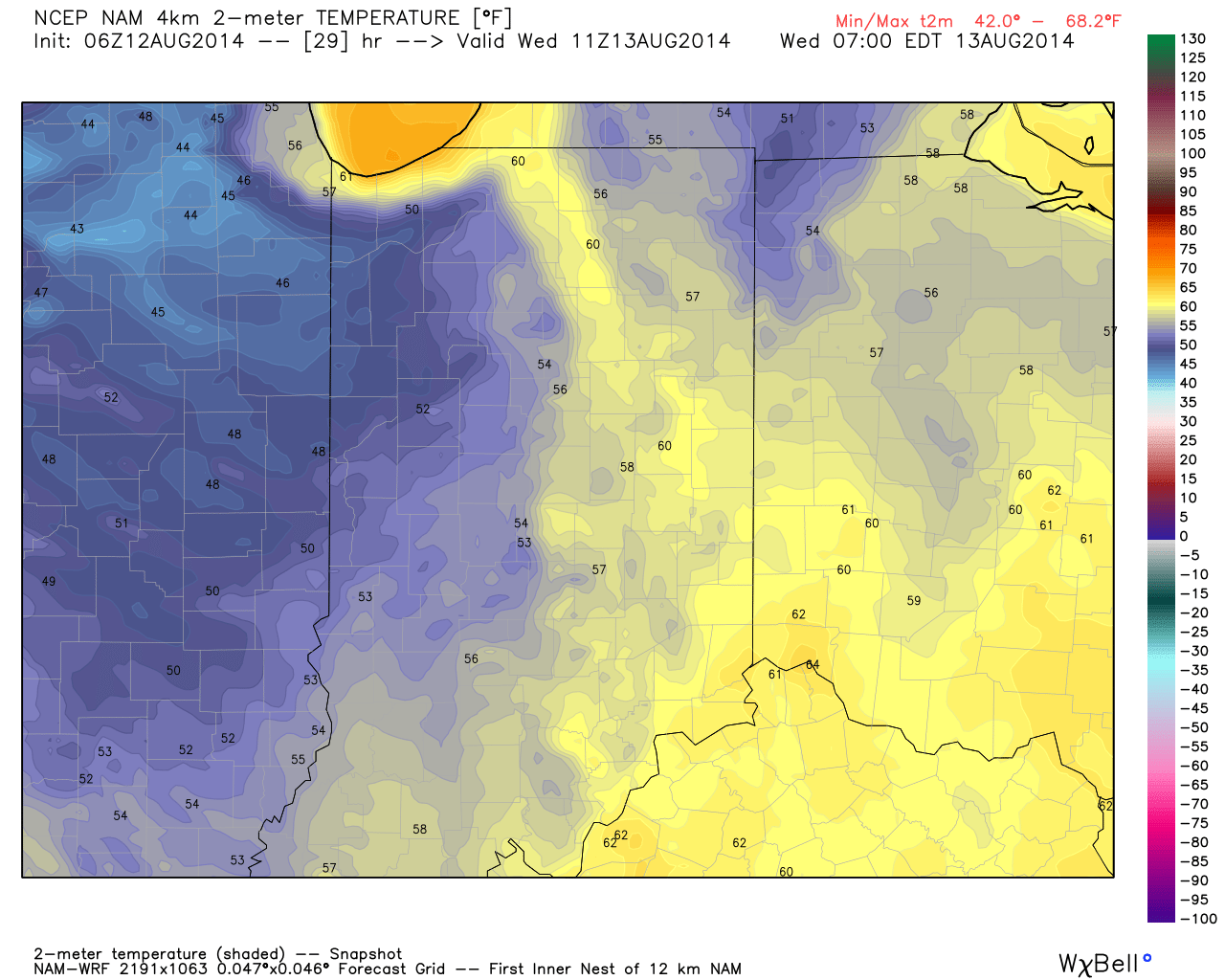
Fall-like temperatures are ahead over the next couple days.  We forecast an official low in the city tonight in the middle 50s, but some upper 40s can be anticipated across western and northwestern suburbs.

Fall-like temperatures are ahead over the next couple days. We forecast an official low in the city tonight in the middle 50s, but some upper 40s can be anticipated across western and northwestern suburbs.

Permanent link to this article: https://indywx.com/2014/08/12/fall-like-feel/

Feeling Tropical Now, But Cooler Air Coming…

Mon.

Tue.

Wed.

Thr.

Fri.

Sat.

Sun.

 Status-weather-storm-night-icon

 Status-weather-showers-day-icon

 Status-weather-clouds-icon

 Status-weather-clouds-icon

 Status-weather-clouds-icon

 Status-weather-clouds-icon

 Status-weather-showers-day-icon

68/ 80

60/ 74

54/ 76

55/ 79

58/ 80

58/ 82

64/ 85 

Air You Can Wear…We’re awaking to lots of fog and very muggy conditions.  Dew points remain in the upper 60s and lower 70s (very oppressive)!  A shower or thunderstorm will be possible really at any time today, but most likely this afternoon as the first of two cold fronts drops into the region.  Similar to yesterday, locally heavy downpours will certainly be possible with all of the moisture in the air.

A secondary cold front will blow through Tuesday with a continued chance of scattered showers and thunderstorms.  We’ll get in on a much cooler and drier air flow Tuesday evening and this will set the stage for a very pleasant rest of the work week, including below normal temperatures into the weekend.

Warming Up; Chance Of Storms…Temperatures will moderate and we’ll introduce showers and thunderstorms into your forecast Sunday.  Early thinking on next week suggests a potentially unsettled (stormy) one, but warmer than average.

7-Day Precipitation Outlook:

  • 7-Day Rainfall Forecast: 0.50″-1.00″
  • 7-Day Snowfall Forecast: 0.00″
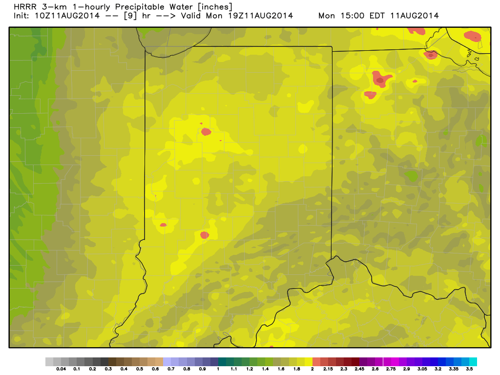
Precipitable water values will once again approach 2" today and assist in locally torrential downpours around the region.

Precipitable water values will once again approach 2″ today and assist in locally torrential downpours around the region.

Permanent link to this article: https://indywx.com/2014/08/11/feeling-tropical-now-but-cooler-air-coming/

Another Cool Period Looming Before We Crank The Heat…

Cooler than normal air masses have been lined up this summer as frequently as airliners waiting to land at Atlanta-Hartsfield airport. With that said, it’s only fitting that we’re targeting…

You must be logged in to view this content. Click Here to become a member of IndyWX.com for full access.  Already a member of IndyWx.com All-Access?  Log-in here.

Permanent link to this article: https://indywx.com/2014/08/10/another-cool-period-looming-before-we-crank-the-heat/

Another Shot Of Cool Air Next Week, But Is A Warmer Period Looming Late Month?

Good evening and happy Friday!  Tonight’s video looks at the weekend weather, another push of cool air next week, and touches on the long range looking at late August and…

You must be logged in to view this content. Click Here to become a member of IndyWX.com for full access.  Already a member of IndyWx.com All-Access?  Log-in here.

Permanent link to this article: https://indywx.com/2014/08/08/another-shot-of-cool-air-next-week-but-is-a-warmer-period-looming-late-month/

Focusing On Saturday…

Thr.

Fri.

Sat.

Sun.

Mon.

Tue.

Wed.

 Status-weather-showers-day-icon

 Status-weather-showers-day-icon

 Status-weather-showers-day-icon

 Status-weather-clouds-icon

 Status-weather-clouds-icon

 Status-weather-clouds-icon

 Status-weather-clouds-icon

58/ 80

60/ 81

60/ 81

59/ 82

62/ 84

63/ 86

66/ 87 


Continued Cooler Than Normal…The Great Lakes region and northern Ohio Valley will remain under the influence of a swirling upper low.  This will keep better rain shower and embedded thunderstorm chances across northern parts of the state this afternoon.  We’ll maintain mention of a widely scattered shower here this afternoon and again Friday, but coverage will be reduced from that which we’ve seen over the past couple days.

Questionable Saturday…Forecast models certainly aren’t in agreement on our weekend forecast and range from a dry and warm Saturday (European solution) to one that features plenty of cloudiness and showers around (GFS solution).  The GFS has been the most consistent on our weekend forecast the past several days and we’ll lean our Saturday forecast more in that direction for now.  Stay tuned.

Slow Warming Trend Ahead Of Next Storm…A warming trend will continue into the early and middle parts of next week as temperatures reach seasonal to slightly above average levels for a couple days.  Our next significant storm system appears to be on the horizon late next week and include rain and storm chances along with another cool down.

7-Day Precipitation Outlook:

  • 7-Day Rainfall Forecast: 0.50″-1.00″
  • 7-Day Snowfall Forecast: 0.00″

Permanent link to this article: https://indywx.com/2014/07/31/focusing-on-saturday/

IndyWx.com