Category: Unseasonably Warm

Sun-Filled Forecast Continues…

Wed.

Thr.

Fri.

Sat.

Sun.

Mon.

Tue.

 Status-weather-clouds-icon

 Status-weather-clouds-icon

 Status-weather-clouds-icon

 Status-weather-clouds-icon

 Status-weather-clouds-icon

 Status-weather-showers-day-icon

 Status-weather-showers-day-icon

4675

5078

5178

5680

5782

5980

5876 

Closing Out The Work Week On A Beautiful Note…High pressure will remain in firm control of our weather as we put a wrap on the work week.  After a chilly open to the week, temperatures will moderate closer to seasonal levels today and above normal levels late week, continuing into early next week.  Lots of sunshine will remain locked into your forecast picture.

Moisture Slowly Returns…Moisture will slowly return as we progress into early next week.  Most, if not all, of Monday should be dry, but we’ll include the chance of an isolated shower.  Scattered shower chances continue Tuesday.

Upcoming 7-Day Precipitation Forecast

  • 7-Day Rainfall Forecast: 0.10″-0.25″
  • 7-Day Snowfall Forecast: 0.00″

Are you a fan of winter weather? Just for fun this morning we thought we’d show you the latest JAMSTEC seasonal forecast that’s hot off the press.  This implies plenty of “fun and games” if you’re a snow and cold fan… More details ahead as we progress deeper into fall.

ByS63lfCUAEA5I-.jpg-large

Permanent link to this article: https://indywx.com/2014/09/24/sun-filled-forecast-continues/

Long Stretch Of Dry Weather…

Mon.

Tue.

Wed.

Thr.

Fri.

Sat.

Sun.

 Status-weather-clouds-icon

 Status-weather-clouds-icon

 Status-weather-clouds-icon

 Status-weather-clouds-icon

 Status-weather-clouds-icon

 Status-weather-clouds-icon

 Status-weather-clouds-icon

46/ 64

45/ 70

47/ 75

49/ 77

50/ 78

52/ 79

59/ 79 

Tranquil Autumn Weather…A prolonged stretch of dry weather is on tap as we open a new work week.  While we’ll start the week off on an unseasonably cool note, temperatures will moderate back to seasonal levels by mid week and above normal levels heading into next weekend.  The next chance of rain won’t arrive until late Sunday and even that is not a good chance (not worth even mentioning in the forecast above just yet).

For all of you fall foliage fans out there, the combination of early cool air through September combined with the extended stretch of dry, sunny days has led to an early start to the color show.  With continued tranquil weather expected, anticipate ideal conditions for continued increased color in the days and weeks ahead.

Upcoming 7-Day Precipitation Forecast:

  • 7-Day Rainfall Forecast: 0.00″
  • 7-Day Snowfall Forecast: 0.00″

We enjoyed a colorful sunset last night off the IndyWx.com observation deck.  🙂

ByGEW9uIEAAfr8J


Permanent link to this article: https://indywx.com/2014/09/22/long-stretch-of-dry-weather/

Weekly Outlook: Cool Start, Mild Finish

A secondary cold front is moving into central Indiana this afternoon with clouds, gusty northerly breezes, and fresh cool air. Speaking of cool, September, so far, has been cooler and…

You must be logged in to view this content. Click Here to become a member of IndyWX.com for full access.  Already a member of IndyWx.com All-Access?  Log-in here.

Permanent link to this article: https://indywx.com/2014/09/21/weekly-outlook-cool-start-mild-finish/

More Great Weather Ahead…


Thr.

Fri.

Sat.

Sun.

Mon.

Tue.

Wed.

 Status-weather-clouds-icon

 Status-weather-clouds-icon

 Status-weather-clouds-icon

 Status-weather-showers-day-icon

 Status-weather-clouds-icon

 Status-weather-clouds-icon

 Status-weather-clouds-icon

47/ 70

49/ 73

54/ 81

56/ 75

51/ 69

49/ 70

47/ 70 

Dry Weather Continues…Our dry stretch will grow over the upcoming few days.  High pressure will remain in control of our weather and supply lots of sunshine.  Temperatures, though while moderating from the unseasonably cool levels we’ve experienced the past week, will remain below normal through the rest of the work week.  We’ll get one day of above normal warmth and that will come Saturday amidst breezy southwest winds and increasingly cloudy skies late.

Cold Front Moves Through…A cold front will move through the region Sunday.  While we don’t anticipate heavy rainfall, scattered showers and thunderstorms will enter the picture as early as Saturday night and continue into Sunday.

Back To Sunshine…Cooler air and dry skies return to kick off the new work week!  More ideal autumn weather is ahead in time for the official start of fall (we’ve been in meteorological fall since September 1st).

Upcoming 7-Day Precipitation Forecast:

  • 7-Day Rainfall Forecast: 0.25″ – 0.50″
  • 7-Day Snowfall Forecast: 0.00″

Permanent link to this article: https://indywx.com/2014/09/18/more-great-weather-ahead/

Sun-Filled Weather Until Sunday…

Wed. Thr. Fri. Sat. Sun. Mon. Tue.               45/ 69 49/ 71 49/ 73 56/ 82 58/ 78 52/ 72 48/ 63  MO Storms…

You must be logged in to view this content. Click Here to become a member of IndyWX.com for full access.  Already a member of IndyWx.com All-Access?  Log-in here.

Permanent link to this article: https://indywx.com/2014/09/17/sun-filled-weather-until-sunday/

Catching Up On A Tuesday Evening…

Several interesting weather items are on the docket and each will have to be dealt with as they come over the course of the upcoming 7 days.  Some of the headlines include a brief warm-up Saturday, weekend rain that could include a tropical connection Sunday, and another big shot of October-like chill next week.

While we have a few more days of below normal temperatures in front of us, we eye at least one day where temperatures will manage to climb above normal and that’s Saturday.  All indications still suggest we’ll be very close, if not a degree or two higher, than the 80 degree mark along with a nice southwest air flow in place Saturday.  All-in-all, it’ll be a great day to take care of any early-autumn yard work that’s needing to get done.

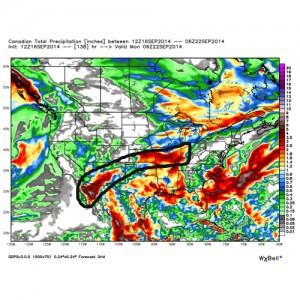
Changes brew Sunday as a cold front draws near.  This is where questions lie and they actually have to do with Tropical Storm Odile (currently all the way to our southwest over the central Baja California peninsula region).  Odilemoisture

While the GFS and European forecast models still aren’t interested in “welcoming” Odile’s moisture into the region, we note the Canadian model does suggest some tropical moisture, courtesy of Odile, gets entangled along the front Sunday.  We’ll continue to keep a close eye on things and monitor the forecast data accordingly moving forward through the back half of the work week.


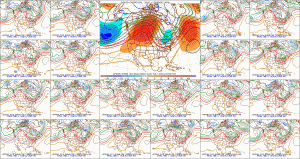
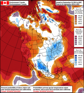
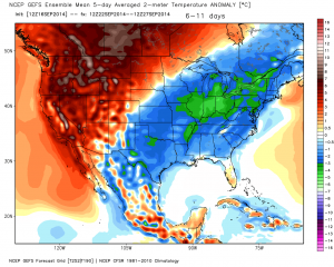
The other item of interest has to do with yet another big blast of autumn air that will have things feeling very much like October around these parts come early next week.  The above average temperatures Saturday will hang around just for the day as yet another unseasonably chilly air mass moves into the area Monday into Tuesday of next week as a significant trough develops over the east with an impressive western ridge in place.  f156


Note the GEFS and Canadian show the return of the unseasonable chill next week.  Keep those jackets handy.  Early indications would suggest this type air mass is plenty capable of highs in the upper 50s/ lower 60s and overnight lows in the upper 30s/ lower 40s during the height of the chill (most likely Tuesday).  Stay tuned…

2014091600_054@007_E1_north@america_I_NAEFS@TEMPERATURE_anomaly@probability@combined@week2_198gefs_t2anom_by5_conus_45


Permanent link to this article: https://indywx.com/2014/09/16/catching-up-on-a-tuesday-evening/

IndySportsReport.com Football Forecast Highlights Nighttime Storms…

Good morning football fans (best time of year, IMO)!  Your IndySportsReport.com High School Football Forecast features one more warm and humid evening highlighted by an increasingly stormy look as the evening transitions into the nighttime hours.

A cold front will slice into a very warm and humid air mass Friday night.  After a mostly quiet weather day across central Indiana, conditions will begin to go downhill Friday evening and night as the front draws closer.  We’ll monitor a line of thunderstorms approaching the region later tonight and a few of these could be strong to severe.  This shouldn’t be a major severe weather episode, but it only takes one strong to severe storm to make a mess of things.

We'll target 7p to midnight for a line of strong to potentially severe storms to move through central Indiana. Folks attending high school football games should monitor radar and weather conditions.

We’ll target 7p to midnight for a line of strong to potentially severe storms to move through central Indiana. Folks attending high school football games should monitor radar and weather conditions.

Dew points will be oppressive (in the lower 70s) and lead to a muggy feel.  Precipitable water values will reach 2″ in spots and suggest a locally heavy rainfall threat within the stronger storms.

hires_pwat_indy_34

Official IndySportsReport.com high school football forecast for Friday, Sept 5th:

Increasingly cloudy, warm, and humid.  Coverage of showers and thunderstorms will increase from north to south through the evening and nighttime hours.  A few of the storms may become strong to severe and produce vivid cloud-to-ground lightning, locally heavy rain, and strong winds.  Rainfall potential tonight will range from 0.25″ to 0.50″, but some local downpours may push totals closer to 1″ in localized spots.  Temperatures will begin in the mid to upper 80s before slowly falling through the game.

Permanent link to this article: https://indywx.com/2014/09/05/indysportsreport-com-football-forecast-highlights-nighttime-storms/

1-2 Punch Of Cool Coming…

September so far has been dominated by a southeast ridge, presenting a warmer and more humid than average feel to our air- stark contrast from the better part of the…

You must be logged in to view this content. Click Here to become a member of IndyWX.com for full access.  Already a member of IndyWx.com All-Access?  Log-in here.

Permanent link to this article: https://indywx.com/2014/09/04/1-2-punch-of-cool-coming/

Couple Dry Days Ahead Of Friday Storms; Weekend Cool Down…

Wed.

Thr.

Fri.

Sat.

Sun.

Mon.

Tue.

 Status-weather-clouds-icon

 Status-weather-clouds-icon

 Status-weather-showers-day-icon

 Status-weather-showers-day-icon

 Status-weather-clouds-icon

 Status-weather-clouds-icon

 Status-weather-showers-day-icon

63/ 84

62/ 87

67/ 89

58/ 73

51/ 74

51/ 75

56/ 79 

Dry Time…Sun-filled days can be expected after morning fog burns off across outlying areas both today and Thursday.  Temperatures will be a touch above normal.

Friday Night Storms Ahead Of Big Cool Down…A cold front will pass the state early Saturday.  Ahead of this front, a line of strong to severe storms will be possible Friday night.  We’ll fine tune timing as we progress through the next day or two.  A blast of much cooler, drier air will then pour into the state over the weekend.  It’ll feel very much like fall around these parts…

Next Rain Maker…We’ll enjoy another dry and seasonably cool couple days before our next potentially significant rain maker gears up for the middle of next week.  Both the GFS and European forecast models are hinting this could be a significant rain maker, but caution this is still early and fine tuning will be required.

7-Day Precipitation Forecast:

  • 7-Day Rainfall Forecast: 0.50″ – 1.00″
  • 7-Day Snowfall Forecast: 0.00″

Farmer Paul of Full Circle Farm sent in this beautiful fog bank shot this morning.  Full Circle Farm is located across southern Boone County in Whitestown.  We encourage you to check out their web site if you haven’t already.  Thanks, Paul!

BwmoKzlIEAAPEAN


Permanent link to this article: https://indywx.com/2014/09/03/couple-dry-days-ahead-of-friday-storms-weekend-cool-down/

Slightly Less Humid; Still Can’t Rule Out A Storm…

Thr.

Fri.

Sat.

Sun.

Mon.

Tue.

Wed.

 Status-weather-showers-day-icon

 Status-weather-showers-day-icon

 Status-weather-showers-day-icon

 Status-weather-showers-day-icon

 Status-weather-showers-day-icon

 Status-weather-showers-day-icon

 Status-weather-clouds-icon

65/ 87

69/ 89

68/ 88

70/ 83

70/ 87

69/ 83

58/ 82 

Break In Humidity Won’t Last Long…A briefly drier air mass will filter into the region tonight into Thursday, but won’t last long.  Heat and humidity will return to wrap up the work week and move into the weekend.  A couple of storms will be possible Thursday, but most should remain rain-free.

Better coverage of showers and thunderstorms will develop Friday through Sunday.  We’re not talking about a weekend wash out by any means and there will be more dry hours than stormy.

Early Week Cold Front…A cold front will move through the area Tuesday evening and feature a cooler and drier brand of air for mid week.  Stormy times continue beforehand with shower and thunderstorms in our Monday and Tuesday forecast before we dry things out Wednesday.

7-Day Precipitation Forecast:

  • 7-Day Rainfall Forecast: 1.50″ – 2.00″
  • 7-Day Snowfall Forecast:  0.00″
A briefly drier air mass will move into the region late tonight into Thursday.  Humidity will return quickly to wrap up the work week.

A briefly drier air mass will move into the region late tonight into Thursday. Humidity will return quickly to wrap up the work week.

Permanent link to this article: https://indywx.com/2014/08/27/slightly-less-humid-still-cant-rule-out-a-storm/

IndyWx.com