Category: Unseasonably Warm

Cold Thanksgiving…

Thanksgiving

Fri.

Sat.

Sun.

Mon.

Tue.

Wed.

 Status-weather-snow-scattered-day-icon

 Status-weather-snow-scattered-day-icon

 Status-weather-showers-scattered-icon

 Status-weather-showers-scattered-icon

 Status-weather-clouds-icon

 Status-weather-clouds-icon

 Status-weather-showers-scattered-icon

24/ 32

19/ 36

30/ 54

54/ 60

28/ 54

24/ 41

34/ 50 

Happy Thanksgiving…We want to wish each and every one of you a happy and healthy Thanksgiving!  Enjoy the day with family and friends.  We’re incredibly thankful and blessed for your support and to be able to provide you with the latest weather forecasts and discussions throughout central Indiana.  While the morning could offer a few flurries or scattered snow showers, most of the day will be dry and cold.  Average highs are in the upper 40s this time of year.  We’ll fall far below that this Thanksgiving.

Moderating Into The Weekend…Black Friday will continue the cold theme along with a few snow flurries as a weak weather system scoots through the region.  Shoppers will certainly want to bundle up as they tackle those Christmas lists.  That said, the theme of the Thanksgiving weekend will be one that features moderating temperatures.  The milder southwesterly air flow will also serve to provide increasingly cloudy conditions along with pesky light rain late Saturday into Sunday.

Challenging Forecast…A challenging forecast is ahead early next week as cold highs to the north combine with resurgent milder air across the south.  The battle ground lies across the Mid West and Ohio Valley region and we’ll have to remain on our toes for potential changes.  For now we’re going with a colder feel Monday (falling temperatures after a high in the wee morning hours), cold and dry Tuesday, and milder/ wet Wednesday.  Stay tuned.

News and Notes: We’re very excited to let you know that Bill will be joining Ray Steele on Weekend Indiana Saturday morning to talk a little weather and a lot about the Iron Bowl!  Be sure to tune into WIBC 6a-8a Saturday.

Upcoming 7-Day Precipitation Forecast:

  • 7-Day Rainfall Forecast: 0.50″
  • 7-Day Snowfall Forecast: Trace – Dusting

Permanent link to this article: https://indywx.com/2014/11/26/cold-thanksgiving/

Happy Thanksgiving; Important Travel Weekend…

A nor’easter is making a mess of travel (in the air and on the road) up and down the east coast. Also note the clipper system digging through the mid…

You must be logged in to view this content. Click Here to become a member of IndyWX.com for full access.  Already a member of IndyWx.com All-Access?  Log-in here.

Permanent link to this article: https://indywx.com/2014/11/26/happy-thanksgiving-important-travel-weekend/

Tuesday Evening Weather Update (And A Little Iron Bowl Excitement)…

There’s just a little excitement in the McMillan household this time of year…  Between Thanksgiving, the increasingly busy weather pattern, and, of course, the Iron Bowl, it’s almost too much…

You must be logged in to view this content. Click Here to become a member of IndyWX.com for full access.  Already a member of IndyWx.com All-Access?  Log-in here.

Permanent link to this article: https://indywx.com/2014/11/25/tuesday-evening-weather-update-and-a-little-iron-bowl-excitement/

Cold Thanksgiving Ahead…

Tue.

Wed.

Thanksgiving

Fri.

Sat.

Sun.

Mon.

 Status-weather-clouds-icon

 Status-weather-snow-scattered-day-icon

 Status-weather-snow-scattered-day-icon

 Status-weather-clouds-icon

 Status-weather-showers-scattered-icon

 Status-weather-showers-scattered-icon

 Status-weather-showers-scattered-icon

28/ 34

25/ 37

26/ 34

24/ 39

35/ 52

47/ 53

33/ 47 

Much Colder Than Normal; Light Snow Southwest…It’s only fitting that we’ll roll into the Thanksgiving holiday with the same overall weather theme we’ve dealt with for the month of November- MUCH colder than normal.  Dry skies can be expected today (with the exception of a few morning flurries).

Our next weather maker will scoot southeast and impact primarily the far southwestern portions of the region with light snow Wednesday (dusting to less than 1″ of accumulation).  A quick note- these type systems have been known to “overachieve” from time to time and we’ll keep a close eye on things the next 24 hours.

A few scattered snow showers/ flurries will be possible across central Indiana Wednesday into Thanksgiving Day, but shouldn’t amount to much.  Cold will be the big weather story.  Plan to have plenty of fire wood ready to keep a roaring fire going through the Thanksgiving get-togethers.

Black Friday shoppers can expect dry conditions and colder than normal weather continuing, but temperatures will begin to moderate after a cold and frosty start.

Warming Up…Our cold weather pattern will relax as we open up December and provide a taste of the November we never had (temperature-wise, at least :-)).  In fact, a 60 degree reading is possible later next week as a warmer southwesterly air flow takes control.  With the southwesterly flow in place, moisture will increase and we’ll mention the chance of light rain in our weekend forecast.

Upcoming 7-Day Precipitation Forecast:

  • 7-Day Rainfall Forecast: 0.50″
  • 7-Day Snowfall Forecast: Trace – Dusting

Permanent link to this article: https://indywx.com/2014/11/25/cold-thanksgiving-ahead-warm-open-to-december/

Changeable Monday; Note On Thanksgiving; Warm Open To December…

We wanted to touch on a few items of business this evening.  There’s a lot of weather going on this week…

Monday will feature drastic changes in the weather department across central Indiana:

  • Day starts mild and with lingering showers.
  • Strong and gusty winds will reach speeds of 45-50 MPH.  Batten down the hatches!
  • Temperatures crash late morning into the afternoon.  We start in the lower 50s, but fall to the freezing mark for the drive home across western parts of the state.  Eastern Indiana will see 32 degree air by 7-8 o’clock.
  • Scattered snow showers and flurries will fly across central Indiana Monday evening.

Thanksgiving Cold And Snow:

Temperatures will be much colder than average (low to mid 30s for highs and middle 20s for lows).  We’re still tracking a weak disturbance that could distribute light snow across central Indiana Thanksgiving Day.  Accumulations, if any, would fall in the dusting to less than 1″ range.

Opening December Warm:

We’ve been talking about how this exceptionally cold and wintry early season pattern would have to “relax” at some point and that appears to be the case as we open December.  The potential is there for well above normal warmth for the first week to ten days of December before we reload the pattern and introduce colder, more wintry times for mid and late month (anyone dreaming of a White Christmas)?

B3Kv8sVIEAASt_2

Permanent link to this article: https://indywx.com/2014/11/23/changeable-monday-note-on-thanksgiving-warm-open-to-december/

Early Rain Then Cooler…

Latest surface analysis shows a cold front just west of the state this morning and this front will push west to east across the state through the morning hours. Forecast…

You must be logged in to view this content. Click Here to become a member of IndyWX.com for full access.  Already a member of IndyWx.com All-Access?  Log-in here.

Permanent link to this article: https://indywx.com/2014/10/28/early-rain-then-cooler/

Balmy Start To The Work Week, But It Won’t Last…

Mon.

Tue.

Wed.

Thr.

Halloween

Sat.

Sun.

 Status-weather-clouds-icon

 Status-weather-showers-day-icon

 Status-weather-clouds-icon

 Status-weather-clouds-icon

 Status-weather-showers-day-icon

 Status-weather-clouds-icon

 Status-weather-clouds-icon

53/ 77

47/ 64

42/ 54

39/ 55

39/ 50

27/ 45

28/ 54 

Balmy For October…A strong southerly air flow will help temperatures surge to between 75 and 80 degrees across central Indiana neighborhoods this afternoon.  Strong and gusty south winds will reach speeds of 30-35 MPH this afternoon along with partly to mostly cloudy skies.

Cold Front Moves Through…A cold front will move through the area Tuesday and a line of showers and thunderstorms will move through the region late tonight into Tuesday morning out ahead of this frontal system.  Tomorrow will be a cooler day, but it won’t really be until Tuesday night when we notice the chilly air moving back into central Indiana.

Dry, Chilly Mid Week…Dry skies return along with slightly below normal temperatures as we move through the mid week stretch.

Big Push Of Cold Air…A second push of unseasonably cold air will blow in as we get set to wrap up the work week and head into the weekend.  A few showers and gusty winds will accompany the chill for Halloween.  While we’re not looking at any sort of heavy rain, it may prove to be a nuisance, especially when coupled with the chill.

A killing freeze awaits Saturday and Sunday mornings with widespread lows in the 20s.

Upcoming 7-Day Precipitation Forecast:

  • 7-Day Rainfall Forecast: 0.50″
  • 7-Day Snowfall Forecast: 0.00″

Permanent link to this article: https://indywx.com/2014/10/27/balmy-start-to-the-work-week-but-it-wont-last/

Weekly Outlook: Big Weather Changes…

October, month-to-date, shows a reflection of cool anomalies across the Great Lakes region and wetter than normal across the central and Tennessee Valley. The week will get off to an…

You must be logged in to view this content. Click Here to become a member of IndyWX.com for full access.  Already a member of IndyWx.com All-Access?  Log-in here.

Permanent link to this article: https://indywx.com/2014/10/26/weekly-outlook-big-weather-changes/

Short-Term Headline Is The Warmth…

We’ll be back later this afternoon to discuss the big late week chill, but want to focus on the warmth of early week this morning. Today will be gorgeous- wall-to-wall…

You must be logged in to view this content. Click Here to become a member of IndyWX.com for full access.  Already a member of IndyWx.com All-Access?  Log-in here.

Permanent link to this article: https://indywx.com/2014/10/26/short-term-headline-is-the-warmth/

The Ups And Downs Of Autumn…

It simply doesn’t get much better than this!  Wall-to-wall sunshine and temperatures in the lower to middle 70s across central Indiana this afternoon…  If you aren’t outside now, we are making it mandatory to get outside upon reading this!  🙂  Enjoy, as the ups and downs of autumn will send us in an opposite direction late in the upcoming week.

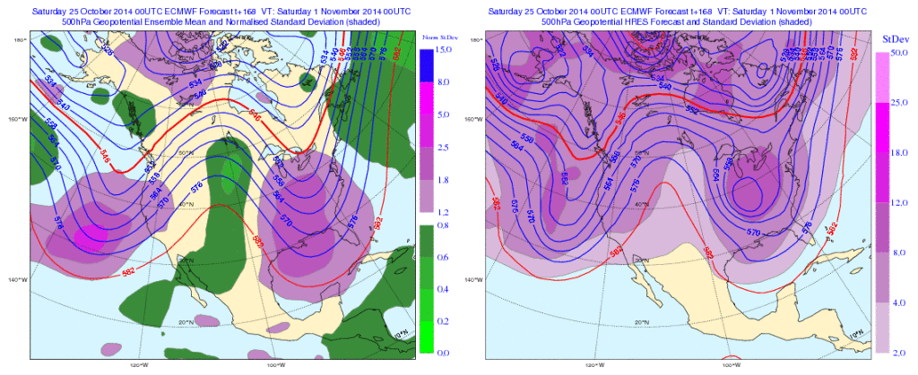
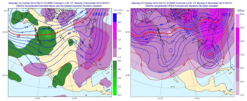
Forecast models are coming into better agreement on the evolution of things heading into next weekend.  While there are still a couple of important differences between the GFS and European, we’re growing increasingly confident on a much colder feel next weekend.

Note the latest GFS operational run stacked atop individual ensemble members.  Needless to say, there’s ensemble support and leads to a higher confidence forecast in the mid range of a deep trough carving itself out across the Mid West and East.  Unseasonably cold air would be associated with this.

GFS


Meanwhile, the European model is more extreme, suggesting a cut off feature develops across the southeast before helping spawn a Nor Easter and leading to high ground accumulating snows from the southern Appalachians northeast along the spine of the mountains.

Again, there’s ensemble support (left) to go with the operational run (right).

EC1

EC2

Whether or not we get some sort of cut off low pressure system to really dig in and help generate high ground snow is up for debate and will be the focal point for many for the upcoming week.

Back here on the home front we’re becoming increasingly confident on the first push of wintry type air here next weekend and timing will have to be fine tuned as we move forward, including the all-important Halloween forecast.  The type air mass moving in will most likely put an end to the growing season across these parts as it’s likely capable of producing multiple below freezing nights.

Much more in the days ahead!  In the meantime, enjoy what we have in front of us now!

Permanent link to this article: https://indywx.com/2014/10/25/the-ups-and-downs-of-autumn/

IndyWx.com