Category: Unseasonably Warm

Warmer Days Coming, But Cool Continues In The Short Term…

Screen Shot 2015-04-27 at 10.18.12 PMHighlights:

  • Cool weather continues through mid week
  • Upper low spawns shower chance Wednesday-Thursday
  • Dry, warmer close to the week
  • Much warmer and more humid early next week with storm chances

1After a cool open to the work week, the next couple of days will continue a similar theme.  We’ll enjoy more sunshine Tuesday when compared to Monday afternoon and temperatures should be a degree or two warmer.

Attention will shift to a potent upper level area of low pressure dropping across the region in the mid week time period.  This will do two things of note- provide reinforcing cool air and help create a scattered shower chance in the Wednesday-Thursday time period. (Scattered 0.10″ to 0.25″ rainfall amounts).

Weather conditions will begin to relax as we put a wrap on the work week.  Expect increasing sunshine and a much warmer pattern.

Warmth and humidity will continue to build early next week and help add fuel to storm potential.

2It’s a rather anomalous look to the 500mb (upper air pattern) charts for mid week, courtesy of Weatherbell.com.  A potent upper level low will dive southeast across the region and help spawn a shower chance, along with provide a much cooler feel of things Wednesday night into Thursday.  Surface low pressure will develop along the SE coast (in response to the UL energy diving southeast) that will provide a windy/ rainy end to the week across coastal regions down east.

3Warmer days are ahead, and more humid days, as well.  Our wind flow will back to the southwest late in the weekend and early next week.  Temperatures will respond, but so will humidity levels.  Throw in a little energy and you have the makings for stormy times to open up next week.

Permanent link to this article: https://indywx.com/2015/04/27/warmer-days-coming-but-cool-continues-in-the-short-term/

Warm May On The Way?

As our attention shifts to May, we wanted to share some of our thoughts on the upcoming month. Due to licensing issues, we’re not allowed to share all of the forecast models that we look at here with you, but did want to give you an idea of some of the data we’re looking at.

The month is likely to open up with an anomalous pattern in place, including one that will support a rather significant coastal storm along the SE coast.  That said, as we progress a bit deeper into the month, guidance suggests a much warmer pattern awaits for those locally across the Ohio Valley and Mid West.

Using a combination of model guidance, here’s an idea of what we’re projecting the upper air pattern to look like as we open the month and progress into the middle of the month.

May1

May10th

As a whole, the majority of forecast data, including analogs of weak El Nino events of the past would imply a warmer than normal May is on the way.  Note the warmer anomalies across the mid South and Ohio Valley region.

Screen Shot 2015-04-26 at 9.23.21 AM


The CFSv2 also is in agreement with the warm idea for May.  Areas where cooler air will be more likely?  The SW and northern tier regions.


Precipitation for April has been running above normal across our region and across the southeast, as a whole.  This is a good sign if you don’t like exceptionally hot and dry summers.  Precipitation this time of year can set the tone for both as we move into the summer months ahead.


For the month of May, we anticipate near normal precipitation (right around 5″), but stress that precipitation isn’t always uniform this time of year as thunderstorms can dump locally heavier totals.

Permanent link to this article: https://indywx.com/2015/04/26/warm-may-on-the-way/

Unseasonably Cool Stretch…

Screen Shot 2015-04-19 at 9.10.05 PMHighlights:

  • More heavy rain and embedded thunder tonight
  • Unseasonably cool air this week
  • Frost and freeze threat

SAT_EUS_WVENH_ANILow pressure over IN this evening will move north into the Great Lakes Monday and strengthen along the way.  A cold front will sweep through the region later tonight and Monday morning and shut off the heavier rainfall.  Before that we have several hours of additional moderate to heavy rain and embedded thunderstorms tonight.  Tomorrow will be a breezy and MUCH cooler day and help set the tone for the week as a whole.  We’ll watch for a weak disturbance to provide a shower chance mid week and keep a close eye on the weekend for the chances of rain.  Model data is in disagreement on Saturday as of now.

RAD_KIND_N0R_ANITonight’s radar, courtesy of WeatherTap.com, shows another slug of moderate to heavy rain and embedded thunder moving in from the south.  Heavy downpours will make for excellent sleeping weather tonight.

Overall rain coverage will decrease significantly as we progress through Monday, but we can’t totally rule out the chance of afternoon showers redeveloping in “pop-corn” fashion as just enough sunshine may work on what will be a very unseasonably cool air mass moving in.

Forecast radar, courtesy of Weatherbell.com, shows this Monday afternoon.

1Unseasonably chilly air will be the rule this week- including 50s for highs most every day.  The only exception may be highs around 60 Tuesday and highs that may not make it out of the 40s Wednesday.  Frost and freeze conditions will be a concern on multiple nights/ mornings this week.

2 3After a warm month (to date) [image 1], Mother Nature will do what she does best- attempt to balance things out the upcoming 7-10 days [image 2].

1 2

Permanent link to this article: https://indywx.com/2015/04/19/unseasonably-cool-stretch/

Almost Summer-like Today Before Sunday Storms…

Screen Shot 2015-04-18 at 8.02.52 AMHighlights:

  • Lower 80s today!
  • Heavy rain and storms Sunday
  • Cooler, showery Monday
  • MUCH cooler next week

SAT_EUS_WVENH_ANIThis morning’s water vapor image, courtesy of Weathertap.com, shows the big swirl over the CO Rockies.  This will continue to move slowly east over the next couple of days.  Surface low pressure will organize over the lower MS Valley tonight and move north into Indiana Sunday afternoon and evening.  After a beautiful Saturday, clouds will increase tonight and widespread rain and thunderstorms will arrive Sunday morning.  With a deep Gulf connection, expect heavy rainfall, as well.  Much cooler air will then take over next week- jackets will be needed!

Before the rain and storms move in Sunday, be sure to enjoy the weather today- lots of sunshine and lower 80s!

hrrr_t2m_max_indy_12Forecast radar, courtesy of Weatherbell.com, shows the wet and stormy Sunday ahead.  Rain will push north through early and mid morning Sunday, continuing into the evening.

hires_ref_indy_32 hires_ref_indy_37 hires_ref_indy_40An average of 1″ to 1.5″ of rain is likely, with isolated heavier totals Sunday.  The model breakdown is below.

The Canadian shows the least amount of rain, with 0.50″ – 0.75″ through central IN.

GEMTotThe GFS paints 1.2″ of rain through central IN, with a “ribbon” of enhanced rainfall along the IN/ IL state line.

GFSTotThe high resolution NAM places emphasis on central and eastern portions of the state, including 1.5″ to 2″ amounts.

NAMTotThe RGEM shows a similar story to the high resolution NAM (above) with 1.5″ to 2″ through central IN.

RGEMTot


Permanent link to this article: https://indywx.com/2015/04/18/almost-summer-like-today-before-sunday-storms/

Friday Evening Video Update…

https://youtu.be/_5kethxFEUw

You must be logged in to view this content. Click Here to become a member of IndyWX.com for full access.  Already a member of IndyWx.com All-Access?  Log-in here.

Permanent link to this article: https://indywx.com/2015/04/17/friday-evening-video-update-3/

Warm Now, But Cooler Times Loom…

Screen Shot 2015-04-17 at 7.28.41 AMHighlights:

  • Early morning dense fog
  • Warm and dry close to the week
  • Wet and stormy second half of the weekend
  • Much cooler next week
  • 7-Day model average precipitation totals range from 1″ to 1.5″, with locally heavier totals

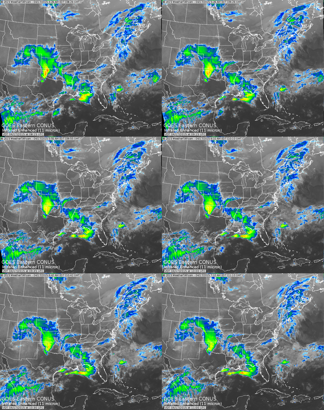
SAT_EUS_IR4ENH_ANIThe infrared satellite this morning, courtesy of Weathertap.com, is showing a significant storm system dumping major snows along the CO Front Range.  Additionally, later today, this storm system will help spawn a severe weather outbreak across eastern CO, NE, and KS.

Locally, we have no weather worries after we rid ourselves of the dense fog currently in place across central Indiana.  Once the fog burns off it’s nothing but sunshine and warmth and an absolute ideal close to the work week and open to the weekend.  Highs today (image 1) will reach the lower to middle 70s and we forecast highs Saturday in the upper 70s (image 2), both courtesy of Weatherbell.com.

hires_t2m_max_indy_5

hires_t2m_max_indy_12Things will begin to transition to stormy times for the second half of the weekend as a “piece” of that big Rocky Mountain storm system breaks away and helps develop a new surface low over the MS River Valley.  This low pressure system will ride into the Ohio Valley and provide widespread showers and thunderstorms Sunday.

Here’s a look at the 2p forecast radar Sunday, courtesy of Weatherbell.com.

hires_ref_indy_61The Storm Prediction Center has outlined far southern portions of the state for a Slight Risk of severe weather Sunday.

day3otlk_0730As we turn our attention to next week, unseasonably cool air will engulf a large portion of the east.  Reinforcing chilly air will push in later next week, after the first surge of chill arrives Monday night/ Tuesday.

D4

Permanent link to this article: https://indywx.com/2015/04/17/warm-now-but-cooler-times-loom/

Warm Close To The Week…

Screen Shot 2015-04-16 at 7.25.29 AMWarm And Dry To Close The Week; MUCH Cooler Next Week…After a wet and noisy night for some, we can’t rule out a shower or thunderstorm really at any time today, particularly across southeastern parts of the state.  However, most of the day will be dry.

Drier air will win out tonight and set the stage for a beautiful and warm close to the week.  Both Friday and Saturday look to offer lots of sunshine and well above normal warmth!  Get out and enjoy, friends!

A cold front will move into the region Sunday into Monday with widespread showers and thunderstorms.  Some of these storms may be strong.  Stay tuned.

The story next week will be one that’s MUCH cooler.  The weather pattern will shift in rather drastic fashion to wrap up the month.  Gone will be the warm southwesterly air flow we’ve come to enjoy most of the month and in it’s place will be a significant trough and associated northwest flow.  As such, we can expect multiple surges of cooler than normal air during the last 7-10 days of the month.

Upcoming 7-Day Precipitation Forecast:

  • 7-Day Rainfall Forecast: 1.00″ – 1.50″
  • 7-Day Snowfall Forecast: 0.00″

Permanent link to this article: https://indywx.com/2015/04/16/warm-close-to-the-week/

Weekend Questions…

Screen Shot 2015-04-14 at 9.38.13 PMNot As Bad As It May Look…Most of the day Wednesday will feature dry conditions and pleasant temperatures.  Moisture will stream in from the south Wednesday evening and nighttime showers will develop across central Indiana, continuing into Thursday (though we can also expect several dry hours).

Friday will also feature mostly dry conditions, but we’ll maintain a mention of a widely scattered shower.  Overall, increasing sunshine and a southerly air flow will help boost temperatures into the lower 70s Friday.

The weekend features lots of questions as two of our more trusted computer models are in totally different camps as of this evening.  The European suggests dry and warm conditions (a great weekend, weather-wise) will rule; however, the GFS model is more unsettled and cooler.  For now we’ll take a blend of the two, leaning more towards the GFS due to better run-to-run consistency.  Stay tuned as updates will be required.

Cooler air will become the story as we open next week and jackets may be needed Tuesday with a gusty northwest breeze.

Upcoming 7-Day Precipitation Forecast:

  • 7-Day Rainfall Forecast: 0.50″ – 1.00″
  • 7-Day Snowfall Forecast: 0.00″

Permanent link to this article: https://indywx.com/2015/04/14/weekend-questions/

Line Of Showers And T-storms Early This Afternoon…

A thin line of showers and thunderstorms will push through central Indiana around lunchtime through the early afternoon hours.  The HRRR (top) is much less aggressive than the high resolution…

You must be logged in to view this content. Click Here to become a member of IndyWX.com for full access.  Already a member of IndyWx.com All-Access?  Log-in here.

Permanent link to this article: https://indywx.com/2015/04/13/line-of-showers-and-t-storms-early-this-afternoon/

Nice Close To The Weekend…

Screen Shot 2015-04-12 at 10.07.58 AMWrapping Up The Weekend On A Nice Note…Look for lots of sunshine to start the day before mid and high level cloudiness slowly increase during the second half of the day.  It’ll be a warm afternoon as highs approach 70 degrees.

Moisture will increase ahead of a cold front that will sweep through central Indiana Monday afternoon/ evening.  Some of the shorter term forecast models are hinting at a thin line of thunderstorms preceding the frontal passage Monday afternoon.

We’re back to dry and pleasant conditions Tuesday and Wednesday, but the dry times won’t last.  A rather unsettled pattern appears to lie ahead late week and heading into next weekend. There’s considerable inconsistencies with run to run output from our computer models, so the forecast confidence during the aforementioned period is lower than normal.  Stay tuned.

Upcoming 7-Day Precipitation Forecast:

  • 7-Day Rainfall Forecast: 0.75″ – 1.25″
  • 7-Day Snowfall Forecast: 0.00″

Permanent link to this article: https://indywx.com/2015/04/12/nice-close-to-the-weekend/

IndyWx.com