I had this set to post Friday evening, and apologize it’s just getting on now.
You must be logged in to view this content. Click Here to become a member of IndyWX.com for full access. Already a member of IndyWx.com All-Access? Log-in here.

Dec 12
I had this set to post Friday evening, and apologize it’s just getting on now.
You must be logged in to view this content. Click Here to become a member of IndyWX.com for full access. Already a member of IndyWx.com All-Access? Log-in here.
Permanent link to this article: https://indywx.com/2015/12/12/weekend-warmth/
Dec 11
The huge story this weekend will be the record warm weather. We’ll likely set records both Saturday and Sunday in the mid to upper 60s. The balance of…
You must be logged in to view this content. Click Here to become a member of IndyWX.com for full access. Already a member of IndyWx.com All-Access? Log-in here.
Permanent link to this article: https://indywx.com/2015/12/11/warm-warm-warm/
Dec 09
You must be logged in to view this content. Click Here to become a member of IndyWX.com for full access. Already a member of IndyWx.com All-Access? Log-in here.
Permanent link to this article: https://indywx.com/2015/12/09/changes-are-brewing-friends/
Dec 09
Relatively quiet weather remains in the near-term period. A fast moving disturbance will cross the state this morning and could spark a light shower or sprinkle, but we’ll get back to increasingly sunny conditions this afternoon and evening.
Moisture will begin to return as we close the week and head into the weekend, but it’s really not until the second half of the weekend that we begin looking at more widespread rain.
As a SW flow begins to transport Gulf of Mexico (GoM) moisture north, a light passing shower is possible Friday evening and Saturday.
Despite the increase in cloudiness and threat of a passing shower, it won’t keep us away from flirting with records Saturday, and note the widespread portion of the Tennessee and Ohio Valley that will also be in jeopardy of setting new records.
Much better rain and storm chances ramp up Sunday afternoon into Monday.
PWATs (precipitable water values) increase dramatically during the aforementioned time period and could help fuel locally heavy rains during that time period, particularly with embedded thunderstorms.
Cooler air will arrive early next week, but remain significantly above normal. We’ll discuss the longer range a bit later…
Permanent link to this article: https://indywx.com/2015/12/09/record-warmth-coming-rain-and-storms-as-well/
Dec 07
Ironically, the only area of normal to below normal air (with the exception of the Rockies and southern Plains) is located over our region, month-to-date.
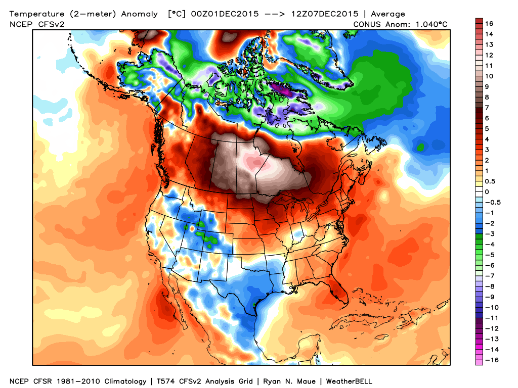 From a winter lover’s perspective, this December has been one to forget this far, and it’ll only grow more frustrating in the days ahead (we still forecast mid to upper 60s over the weekend).
The basic drivers of our pattern remain generally unchanged from ideas in October when we posted our Winter Outlook. Our complete Winter Outlook can be found here. We feel the need to remind some that we thought we would get off to warmer than normal and relatively quiet start:
In short, there’s nothing out there that would suggest any reasons we should deviate from our current winter outlook that’s out there. Despite the warm start, we still feel the winter, when all totaled up, will end up slightly colder than normal. Additionally, though still falling short of normal snowfall, we also feel there will be plenty of winter weather potential come mid and late winter.
That leads us to the shorter term and what happens after the near record warmth of the upcoming weekend.
To sum it up:
Bottom line is that the overall pattern is one that favors more in the way of warmer than average conditions through the next couple weeks before we begin transitioning towards more sustained wintry conditions mid and late winter. The idea here is that with each successive storm that comes through, it’ll cut into the mean ridge position and the heights will continue to lift further and further north with time over the upcoming 10-14 days. The GFS ensembles show this.
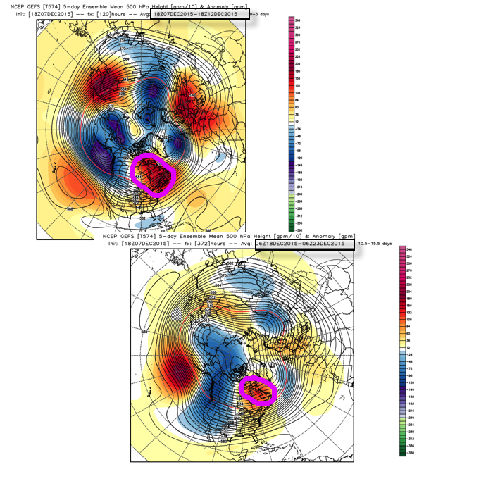 Is it an ideal set up for “lock and load” winter? Not at all. Is it an improvement that can at least offer up a couple attempts of wintry potential around Christmas? Yes.
As stated above, in the longer term, based off current data and seasonal modeling, there’s no reason to walk away from the idea the slow start to winter continues for the duration. Patience friends. 🙂
Permanent link to this article: https://indywx.com/2015/12/07/patience-required/
Dec 07
A quick glance at the updated 7-day shows two things, a lack of cold air and a rather active time of things. In the near term, it remains a relatively quiet period. We’ll deal with morning fog in spots this morning (especially north-central IN) and another fast moving disturbance in the Tuesday night-Wednesday time frame.
The big story as we move into the back half of the week is the unseasonably warm regime that will have many asking “What season are we in?” We’ll aim for the upper 50s Thursday, around 60 Friday, and upper 60s Saturday as a strong SW flow develops in advance of our next storm system
While a scattered, fast moving, shower is possible Saturday, the big story will be the warmth and a gusty SW breeze.
Our storm system will grow closer Sunday and we’ll ramp up rain and storm chances accordingly during that period. Our two most trusted global models handle things differently as we progress into the Sunday-Monday time frame (strength, track, and timing), and we’ll need to continue to fine tune that particular period as we move forward. As it stands now we’ll forecast rain and thunderstorms to become widespread Sunday before colder air arrives on the backside of the storm. Stay tuned.
Permanent link to this article: https://indywx.com/2015/12/07/what-season-is-this-active-pattern-develops/
Dec 06
The near term period is about as quiet as you’ll get it this time of year so that gives us an opportunity to search for the next “trouble maker.” Out…
You must be logged in to view this content. Click Here to become a member of IndyWX.com for full access. Already a member of IndyWx.com All-Access? Log-in here.
Permanent link to this article: https://indywx.com/2015/12/06/major-warmth-ahead-of-storm-next-weekend/
Dec 05
You must be logged in to view this content. Click Here to become a member of IndyWX.com for full access. Already a member of IndyWx.com All-Access? Log-in here.
Permanent link to this article: https://indywx.com/2015/12/05/warm-late-next-week-active-times-loom-for-the-2nd-half-of-december/
Dec 04
In the short-term, “dirty” high pressure will remain in control of our weather as we welcome in the weekend. We label this a “dirty” high as a local inversion has resulted in plenty of low clouds and fog over the past couple days, despite high pressure being overhead. Unfortunately, the weekend will get off to a similar gloomy, foggy start. With temperatures below freezing overnight and Saturday morning, areas of freezing fog can once again be anticipated. Take it slow if you must be out and about early Saturday. We keep our fingers crossed that we’ll be able to mix things up just enough to allow for at least some sunshine come afternoon.
The upcoming week will feature two upper air disturbances tracking across the state. One comes Monday and the second arrives Wednesday. Both will offer up an increase in cloudiness and a light shower chance.

Monday’s 500mb chart shows the first of two upper air disturbances set to cross the state. Source: NCEP
Once we get to late next week, a southwesterly air flow will take control and pump unseasonably warm air into the Mid West and Ohio Valley. The mild air will be out ahead of an approaching storm system next weekend and we still anticipate changes as we progress into mid month…
Permanent link to this article: https://indywx.com/2015/12/04/happy-weekend/
Dec 03
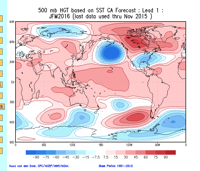
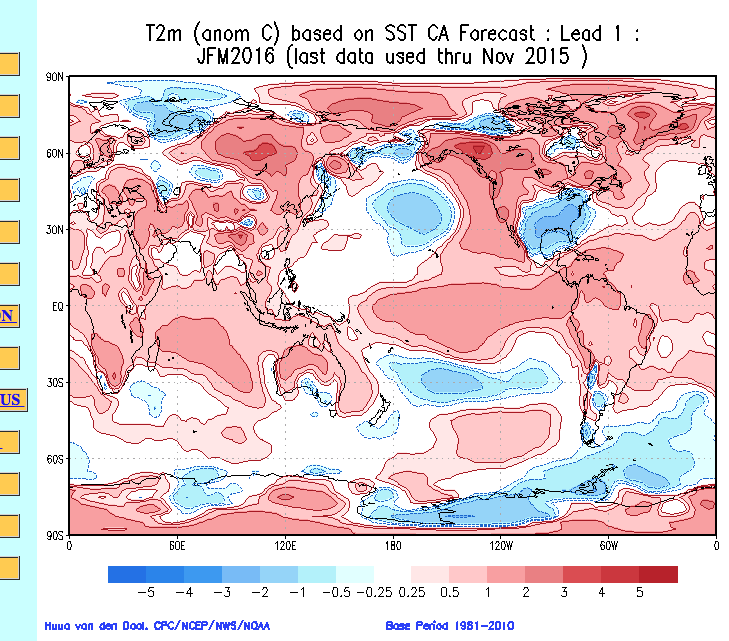
The updated constructed analog model is in the house and holds steady with the on-going idea from previous months.
Upper air pattern for Jan., Feb., and March
 Temperature anomalies for Jan., Feb., and March
 Precipitation anomalies for Jan., Feb., and March
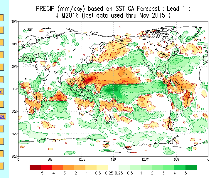 Based on this update, we really don’t see anything that would suggest we need to change our ongoing thinking this winter.
While the mainstream national media seems to continue to push the warmth this winter, we just don’t see it that way. It doesn’t mean that we’re guaranteed to be correct, but at least we’ve outlined our reasoning behind why we disagree with that idea in countless previous posts (that can be found in the archives).
As it stands now, we are really becoming bullish on the possibility we turn much more active for mid and late month. This will come after a relatively quiet and mild first two weeks of December. The SOI has been tanking for several days, but has gone into an all-out tail spin today.
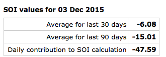 A couple things that come to mind right off the bat with that kind of daily negative value? Poor model performance in the mid range, and an active pattern 10-14 days out. Let’s see how things unfold.
Additionally, latest model data suggests our teleconnections may begin to align in a better fashion for central and eastern cold. Latest runs take the AO slightly negative, the NAO neutral, and trend the PNA back positive towards late month. Not perfect, but we’ll take it.
I heard one prominent national weather source today say December looks warm, quiet, and feature reduced chances of a White Christmas for most compared to normal. Perhaps that will, indeed, be the case. We’re, however, in the camp (small as it may be :-)) that believes a colder and more active period looms leading up to Christmas. We shall see what we shall see…
Permanent link to this article: https://indywx.com/2015/12/03/constructed-analog-model-holds-steady/