Category: Unseasonably Warm
 Highlights:
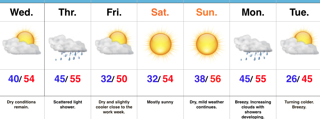
- Northern IN snow
- Weekend moderation
- Showers early next week
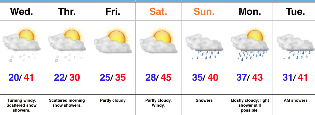
Majority Of Snow To Our North, Northeast…A fast moving northwest flow will continue to zip upper air disturbances across the Plains into the Great Lakes and northeast. As has been the case for the past week, central IN will remain too far south to benefit in the snow department from these systems. A light shower is possible this afternoon with gusty winds followed by a couple of light snow showers this evening as the cold returns. If your travels take you to north-central IN or into Ohio, you’ll be more likely to encounter slick roads.
A skinny lake effect snow band may set up shop overnight into early Thursday. Unlike the past event, this would favor west-central parts of the state.
We’ll wrap up the work week on a mostly dry note and that theme will continue as we open the weekend. A milder southwest push of air will send temperatures to slightly above average levels this weekend and we’ll introduce showers into our forecast early next week.
Upcoming 7-Day Precipitation Forecast:
- Snowfall: Dusting
- Rainfall: 0.25″ – 0.40″
Permanent link to this article: https://indywx.com/2017/12/13/weekend-moderation/
-
Filed under Arctic Cold, Christmas/ Thanksgiving, Ensemble Discussion, Forecast Discussion, Forecast Models, snow, Unseasonably Cool Weather, Unseasonably Warm, Weather Rambles, Winter thoughts...
-
December 12, 2017
I.) The pattern we’re currently dealing with is one that presents multiple challenges in the near term. East-central and northeastern portions of the state have gotten in on the snow act today, but, so far, most of central Indiana has missed out on the snowy goods. With such a fast-paced northwest flow, we have to remain on guard for potential “surprises” in this pattern. Perhaps the HRRR is beginning to pick up on this. Latest runs want to deliver a “pop” of snow Wednesday morning, associated with “warm” air advection (WAA). We’ll monitor tonight.
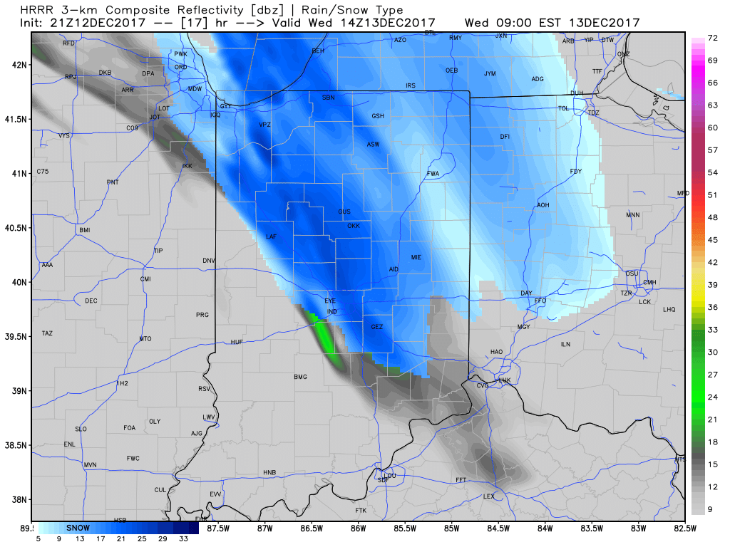
9a forecast radar Wednesday
II. The northwest flow will continue to provide disturbances plenty capable of producing periods of snow again Wednesday evening through the end of the week. Are these monster storms? Hardly, but they can “suddenly” become sufficient enough to create travel problems given the pattern. For those who live across the northern half of the state, plan to keep close tabs to local forecasts if you have travel plans through the end of the week.
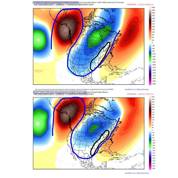
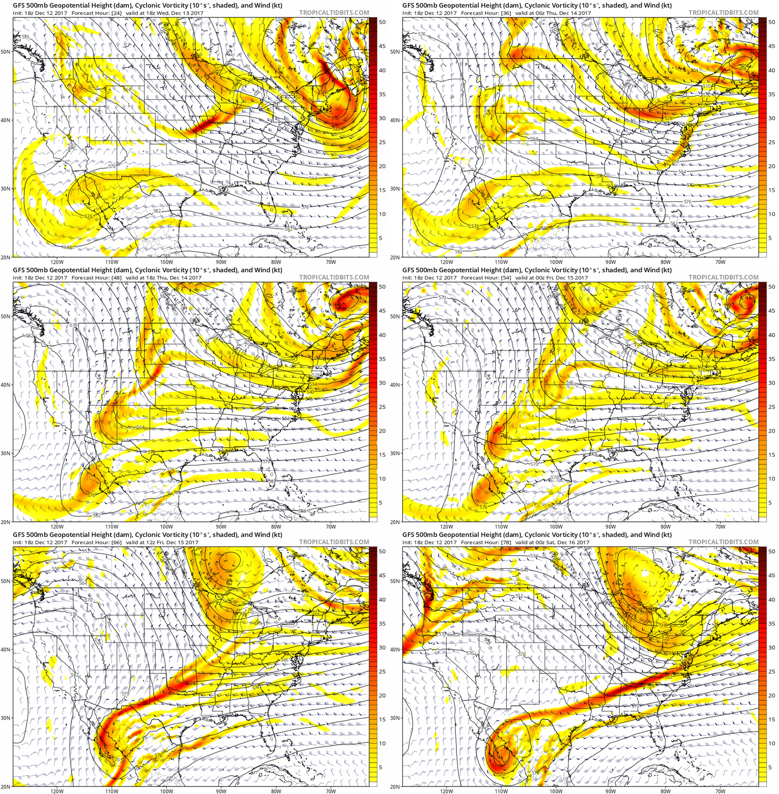 III. A period of brief moderation will come in this pattern early Christmas week, but all eyes continue to focus on the period between December 22nd through December 26th for the potential of impactful weather across our region. For model “worshipers” out there, we suggest paying more attention to overall trends, and a blend of ensemble data, as opposed to specifics associated with operational runs. It’s a “jailbreak” pattern of sorts as true arctic air will be pouring down the Plains while the southeastern ridge tries to fight for a time. The resistance from the southeastern ridge and associated tight thermal gradient should promote a very stormy regime for the interior (Ohio Valley into the interior northeast) as we head into the true holiday/ Christmas stretch. As of now, we favor the idea of multiple waves along the pressing arctic boundary, as opposed to one big storm. Looking back through the records shows some of the heaviest snows at IND have come from similar set-ups. Understanding each set-up is unique, the overall pattern does have to raise an eye brow for potential of wintry weather in, or around, our region as Christmas approaches…
Permanent link to this article: https://indywx.com/2017/12/12/tuesday-evening-rambles-wintry-weather-and-more-christmas-week-chatter/
 Highlights:
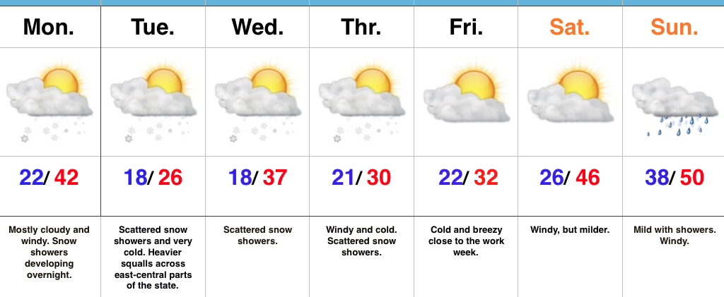
- Snow showers develop overnight
- Another arctic shot
- Milder for the weekend
Snow Showers Develop Overnight…Another fast moving upper air disturbance is on the move southeast this morning and will result in a mostly cloudy and blustery open to the work week. As cold air advection (CAA) kicks in overnight and Tuesday, snow showers will develop across the region. We’ll also note the potential of a more intense and persistent lake effect band setting up across east-central Indiana (where a couple inches will accumulate Tuesday). If your travels take you into eastern and northeastern portions of the state Tuesday, prepare for sudden drops in visibility and slick travel.
Additional upper level energy will scoot through here during the middle part of the work week and while this will help to reinforce the cold, it’ll also provide scattered snow showers.
We’ll switch gears and get into a briefly milder southwesterly air flow over the upcoming weekend. Strong and gusty southwest winds will aid in giving a boost to the mercury, but showers will make for a damp end to the weekend.
Upcoming 7-Day Precipitation Forecast:
- Snowfall: Dusting (for most) to 2″ across east-central Indiana
- Rainfall: 0.25″
Permanent link to this article: https://indywx.com/2017/12/11/another-cold-week-snow-showers-develop-overnight/
 Highlights:
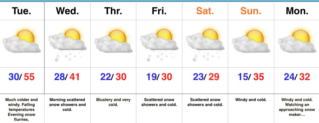
- Falling temperatures Tuesday
- Much colder
- Active northwest flow
Winter Engaged…Showers and embedded thunderstorms will rumble across the state during the overnight as a cold front draws closer. This is a “game changer” of a cold front, separating anomalous warmth over the past few days to a locked and loaded winter pattern. Temperatures will fall through the day Tuesday and just enough wrap around moisture will be present to support mention of evening flurries.
Morning scattered snow showers will continue early Wednesday before a reinforcing blast of arctic air blows into town at night. This will set up a frigid close to the work week and feature a fast paced northwest flow pattern into the upcoming weekend. We’ll have to remain very focused on upper level energy over the weekend. Models have been struggling (as expected given the pattern) on the specifics and we know this type regime can overachieve in the snow department. As things stand now, a period of snow showers with light accumulation still seems like a good bet Friday into Saturday.
Another (potentially more significant) snow event looms early next week…
Upcoming 7-Day Precipitation Forecast:
- Snowfall: 1″
- Rainfall: 0.25″ – 0.75″
Permanent link to this article: https://indywx.com/2017/12/04/here-comes-winter/
-
Filed under Arctic Cold, Forecast Discussion, Forecast Models, Rain, snow, T-storms, Unseasonably Cool Weather, Unseasonably Warm, Weather Videos, Windy
-
December 4, 2017
You must be logged in to view this content. Click Here to become a member of IndyWX.com for full access. Already a member of IndyWx.com All-Access? Log-in here.
Permanent link to this article: https://indywx.com/2017/12/04/video-partys-over-after-today/
 Highlights:
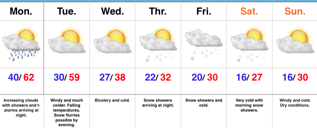
- Showers and t-storms Monday night
- Turning much colder
- Snowy close to the work week
Changes Loom…We couldn’t have asked for a more delightful weekend to open December. Plentiful sunshine helped warm afternoon highs into the 55-60 degree range both Saturday and Sunday across central Indiana. We sure hope you found a way to get out and enjoy it as major changes loom.
A cold front responsible for ushering in these changes will blow through the state Tuesday morning. Ahead of the cold front, look for a line of showers and thunderstorms Monday night. For the most part, rain should be southeast of our region before the morning rush Tuesday. Winds will shift to the northwest and help usher in a much colder air mass through the day. This will set the tone for what the rest of the week will hold (and for that matter, most of the rest of the month).
Cold, dry conditions will be with us for midweek before a vigorous upper level disturbance races southeast across the Ohio Valley to close the work week. Snow showers and unseasonably cold conditions are a given Thursday night through Saturday morning and we’ll have to continue to monitor things closely for the prospects of the season’s first accumulating snow Friday. These type events have been known to “overachieve.”
The cold pattern is just setting in and shows no signs of departing in the longer range. Additional wintry “mischief” looms next week…
Upcoming 7-Day Precipitation Forecast:
- Snowfall: 1″ – 2″
- Rainfall: 0.50″ – 0.75″
Permanent link to this article: https://indywx.com/2017/12/03/winter-sets-in/
-
Filed under AO, Arctic Cold, EPO, Forecast Discussion, Forecast Models, PNA, snow, Unseasonably Cool Weather, Unseasonably Warm, Weather Videos
-
December 1, 2017
You must be logged in to view this content. Click Here to become a member of IndyWX.com for full access. Already a member of IndyWx.com All-Access? Log-in here.
Permanent link to this article: https://indywx.com/2017/12/01/video-winter-set-to-lock-in/
-
Filed under 7-Day Outlook, Arctic Cold, Autumn, Christmas/ Thanksgiving, Forecast, Rain, snow, T-storms, Unseasonably Cool Weather, Unseasonably Warm
-
November 30, 2017
 Highlights:
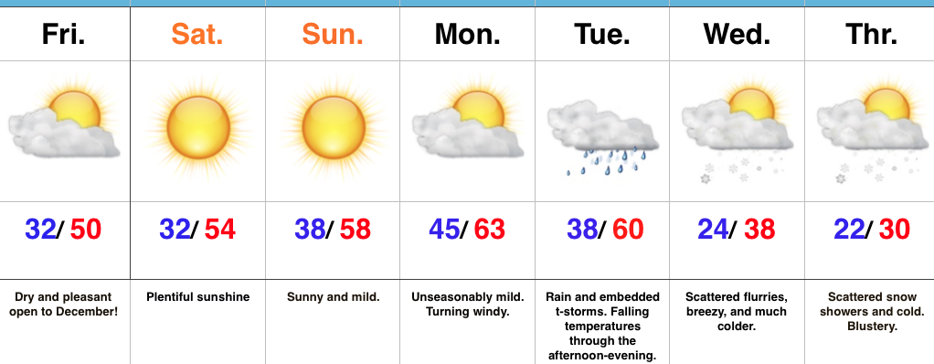
- Mild open to December
- Early week rain and storms
- Hello winter
Great Weekend By December Standards…High pressure will build in overnight and provide beautiful weather to open December. We’ll enjoy plentiful sunshine and well above average temperatures through the weekend and on into early next week. Take our word for it: Enjoy it while you have it!
An approaching storm system will lead to increasing clouds later Monday along with an increasingly gusty southwest breeze Monday afternoon into the evening. A cold front will move through the state Tuesday with widespread rain and embedded thunderstorms. Strong and gusty winds will continue. Once the front sweeps through the state, falling temperatures can be expected Tuesday evening.
The true shift to winter will begin the middle of next week, complete with MUCH colder air, gusty northwest winds, and scattered snow showers. Speaking of winter, if you’re a fan of the cold and snow for the holiday season, the upcoming pattern change will put a smile on your face. A prolonged stretch of cold and wintry conditions should continue through the holidays and into the new year…
Upcoming 7-Day Precipitation Forecast:
- Snowfall: Trace – Dusting
- Rainfall: 1″ – 2″
Permanent link to this article: https://indywx.com/2017/11/30/enjoy-the-mild-weather-while-you-have-it/
 Highlights:
- Weak front passes through Thursday
- Sun-filled, mild weekend
- Big changes await
Enjoying The Relatively Quiet Weather While We Can…Dry conditions will remain in place today before a weak frontal boundary passes through the state Thursday. Enough moisture will return in advance of this front to help spark a couple of light showers, but this won’t be a big deal and several neighborhoods won’t pick up any rainfall.
We’ll get back to dry, quiet weather over the weekend as high pressure builds in. Sunshine and mild weather will continue. Given what looms, it’ll be a perfect weekend to complete any lingering outdoor work or get those Christmas lights up!
Big changes await next week as winter gets ready to settle in. The leading edge of the cold air will be accompanied by showers as we open the work week. Easily the coldest air of the season awaits for later next week…
Upcoming 7-Day Precipitation Forecast:
- Snowfall: 0.00″
- Rainfall: 0.25″ – 0.50″
Permanent link to this article: https://indywx.com/2017/11/29/quiet-weather-continues-big-changes-loom/
You must be logged in to view this content. Click Here to become a member of IndyWX.com for full access. Already a member of IndyWx.com All-Access? Log-in here.
Permanent link to this article: https://indywx.com/2017/11/28/video-generally-quiet-weather-continues-for-now/
 Highlights:

 III. A period of brief moderation will come in this pattern early Christmas week, but all eyes continue to focus on the period between December 22nd through December 26th for the potential of impactful weather across our region. For model “worshipers” out there, we suggest paying more attention to overall trends, and a blend of ensemble data, as opposed to specifics associated with operational runs. It’s a “jailbreak” pattern of sorts as true arctic air will be pouring down the Plains while the southeastern ridge tries to fight for a time. The resistance from the southeastern ridge and associated tight thermal gradient should promote a very stormy regime for the interior (Ohio Valley into the interior northeast) as we head into the true holiday/ Christmas stretch. As of now, we favor the idea of multiple waves along the pressing arctic boundary, as opposed to one big storm. Looking back through the records shows some of the heaviest snows at IND have come from similar set-ups. Understanding each set-up is unique, the overall pattern does have to raise an eye brow for potential of wintry weather in, or around, our region as Christmas approaches…
 Highlights:
 Highlights:
 Highlights:
 Highlights:
 Highlights: