You must be logged in to view this content. Click Here to become a member of IndyWX.com for full access. Already a member of IndyWx.com All-Access? Log-in here.
Category: Unseasonably Warm
Permanent link to this article: https://indywx.com/2019/02/18/impactful-snow-ice-event-gives-way-to-strong-storm-potential/
Feb 18
Monday Morning Video Update: Accumulating Snow Tuesday Night To Weekend Storm Potential…
Light snow showers will continue today, but attention is on the potential of a “thump” of snow tomorrow night into early Wednesday morning. Thereafter, another big storm is set to…
You must be logged in to view this content. Click Here to become a member of IndyWX.com for full access. Already a member of IndyWx.com All-Access? Log-in here.
Permanent link to this article: https://indywx.com/2019/02/18/monday-morning-video-update-accumulating-snow-tuesday-night-to-weekend-storm-potential/
Feb 17
Sunday Morning Video Update…
A wintry mix this morning sets the stage for another active week of weather across central Indiana. We also look forward to late Feb and early March…
You must be logged in to view this content. Click Here to become a member of IndyWX.com for full access. Already a member of IndyWx.com All-Access? Log-in here.
Permanent link to this article: https://indywx.com/2019/02/17/sunday-morning-video-update-3/
Feb 16
All-Access Saturday Evening Video Update…
You must be logged in to view this content. Click Here to become a member of IndyWX.com for full access. Already a member of IndyWx.com All-Access? Log-in here.
Permanent link to this article: https://indywx.com/2019/02/16/all-access-saturday-evening-video-update/
Feb 16
2019 Spring Outlook…
2019 IndyWx.com Spring Outlook
Forecaster: Team; Date Issued: 02.16.19
Last spring was a tale of two seasons in itself. March (featured a foot of snow) and April were significantly colder than normal and then we shifted things to summer in May (the last month of meteorological spring was close to 10 degrees above normal). As a whole, it was a quiet severe weather season.
Despite the wild swings, at the end of the day, things “balanced out” nicely across the central Ohio Valley, including central Indiana.
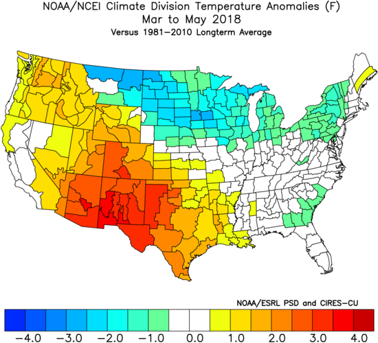
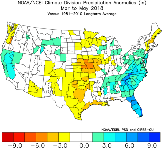
As we look ahead to what the 2019 version holds, here are a few headlines that have our attention:
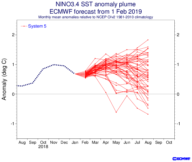
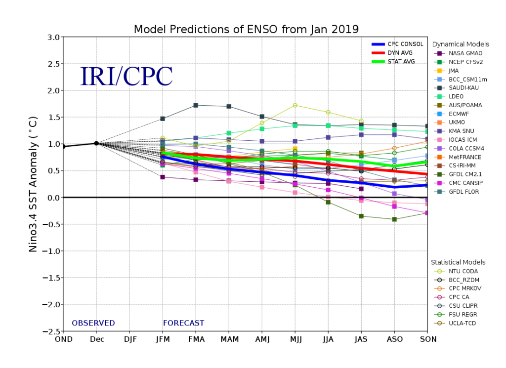
I. Weak Nino is behaving more like a Nina (Tropical Northern Hemisphere pattern can be thanked for this).
II. Neutral NAO is expected
III. Neutral PDO (Pacific Decadal Oscillation)
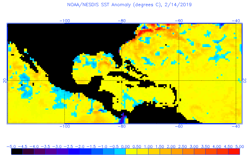
In addition, we’re paying special attention to the SST configuration in the Gulf of Mexico. A warmer than average GOM can most certainly lead to a more “hyper” severe weather season as spring gets going.
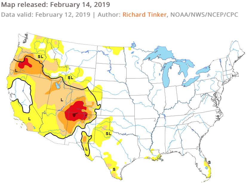
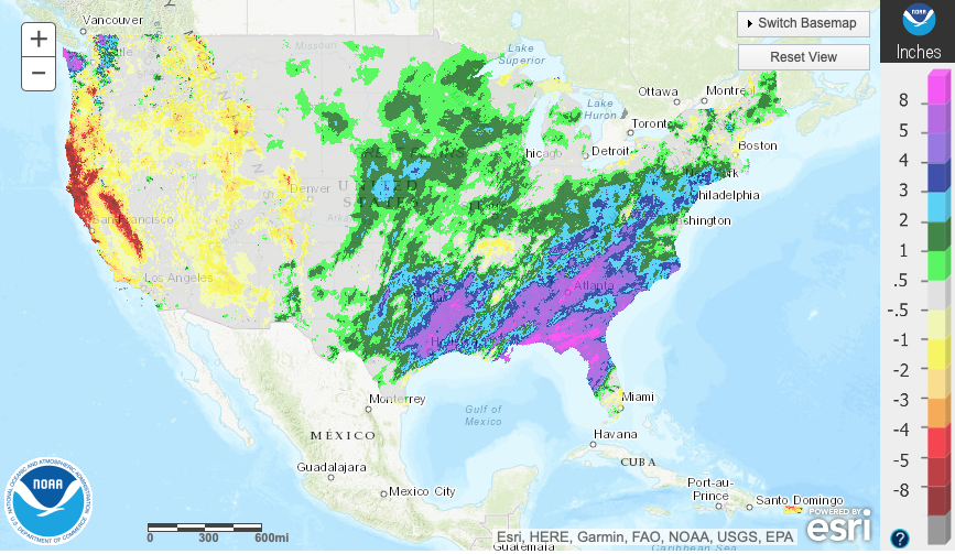
The late winter/ early spring drought monitor can give a hint where early warmth may try and get going. However, this year, we can’t rely on this tool as the Plains and East, including the heart of the #AGbelt, have seen copious amounts of moisture over the winter.

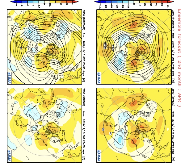
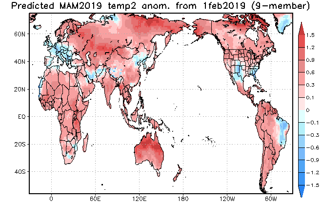
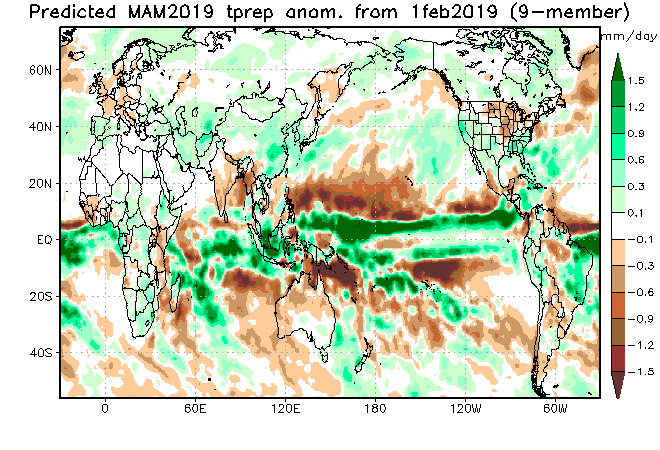
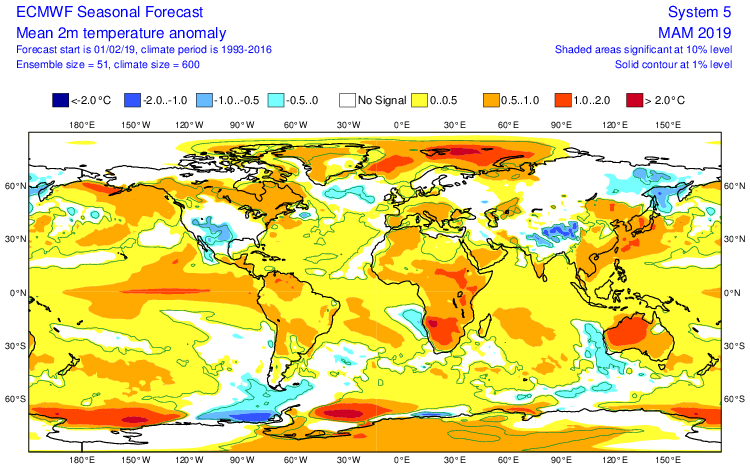
Let’s look at what the model guidance is printing out for meteorological spring:
JMA


CFSv2

JAMSTEC
European Seasonal
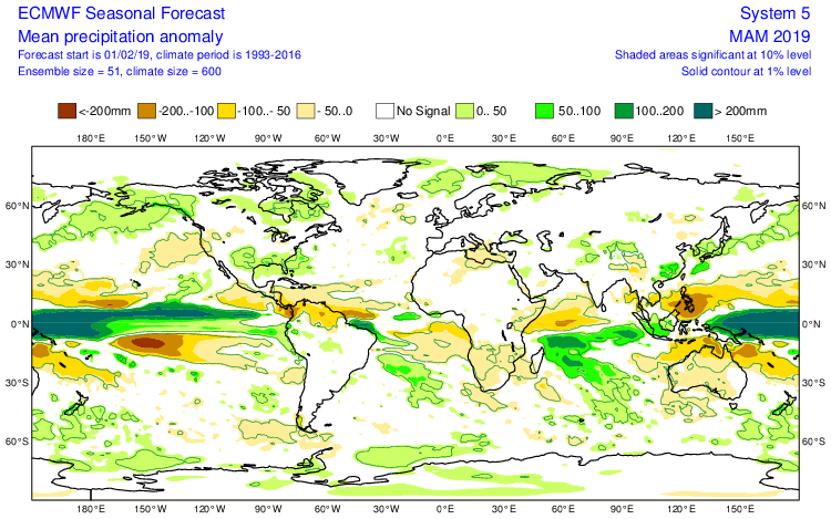
Summary
We anticipate a slightly warmer than average spring season across not only central Indiana, but the Mid West and Ohio Valley region, as a whole. A weak El Nino is expected to persist into the upcoming summer and the conditions typically associated with such should eventually show themselves (as opposed to more of a Nina-like flavor now) through the spring. We agree with the consensus of model guidance above that March is likely to feature the coldest temperatures, relative to normal, and that’s primarily due to what should be a colder 1st half of the month before more bonafide spring conditions take hold the 2nd half of the month. Precipitation is anticipated to run near average, if not slightly below average, levels through the spring. As for severe weather, we expect a much busier season than last year, especially with the warm SSTs lurking in the Gulf of Mexico.
Permanent link to this article: https://indywx.com/2019/02/16/2019-spring-outlook/
Feb 15
All-Access Video Update On The Longer Range, And Honing In On Short-Term Systems…
You must be logged in to view this content. Click Here to become a member of IndyWX.com for full access. Already a member of IndyWx.com All-Access? Log-in here.
Permanent link to this article: https://indywx.com/2019/02/15/all-access-video-update-on-the-longer-range-and-honing-in-on-short-term-systems/
Feb 14
Reviewing The Latest European Weeklies And Updated Long Range Thoughts…
We’re growing closer and closer towards the period we’ve been thinking would present one last round of cold, wintry weather (relative to normal) for the ’18-’19 season.
While the stormy idea will likely end up being correct, the significant cold that we thought would “spread out” (as opposed to being confined to the NW and northern Plains) is in jeopardy.
The overall upper air pattern over the upcoming few weeks will likely continue to be dominated by a mean trough position across the central and west, along with the persistent southeast ridge.
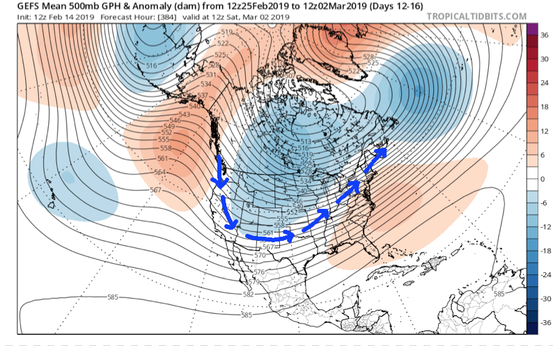
This will continue to result in above normal precipitation into the first week to 10 days of March, with a very active storm track.
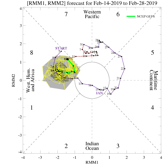
From a temperature perspective, the baseline of our ideas being centered on the MJO appears to be the error in our forecast. It’s not that the MJO isn’t heading into Phase 8 (it’s officially there now, as noted below), but it appears other teleconnections are “trumping” this cold ingredient.

The combination of the positive Arctic Oscillation (AO) and negative Pacific North America pattern (PNA) are the drivers and are showing no signs of wanting to let go of the wheel.
The AO is forecast to remain strongly positive into early March.

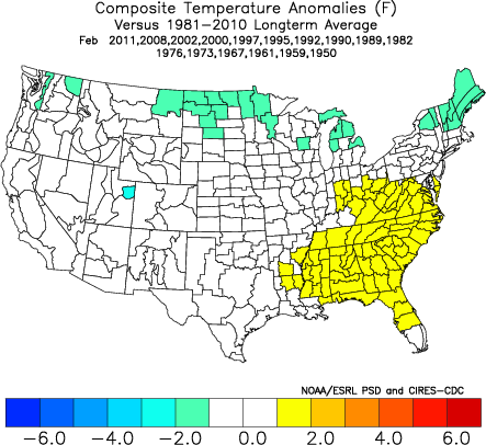
The PNA is forecast to remain negative into early March.
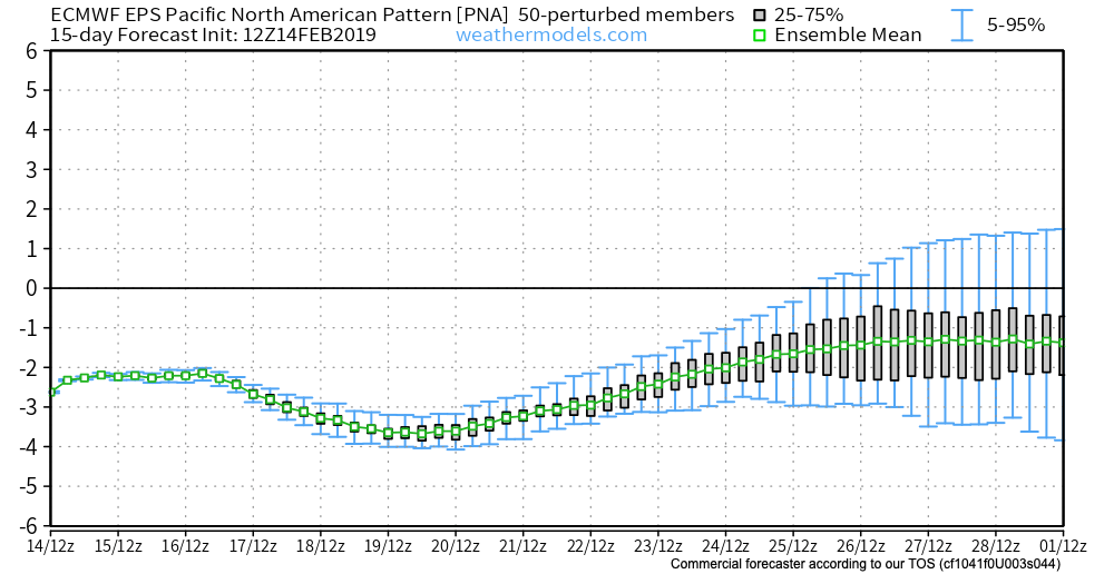

Note how both of the above support that southeast ridge and associated relative warmth.
At one time, it appeared as if the North Atlantic Oscillation (NAO) would dip negative, however, that’s no longer the case.
While the active idea will come to fruition, the cold (at least to the magnitude we thought) will have a difficult time. That isn’t to say that enough cold air won’t get involved with a couple of these storms to result in wintry precipitation of significance, but rather that sustained cold will be tough to come by. Snowfall (of the heavy, wet variety) very well still could end up above normal with these moisture-laden systems over the next few weeks.
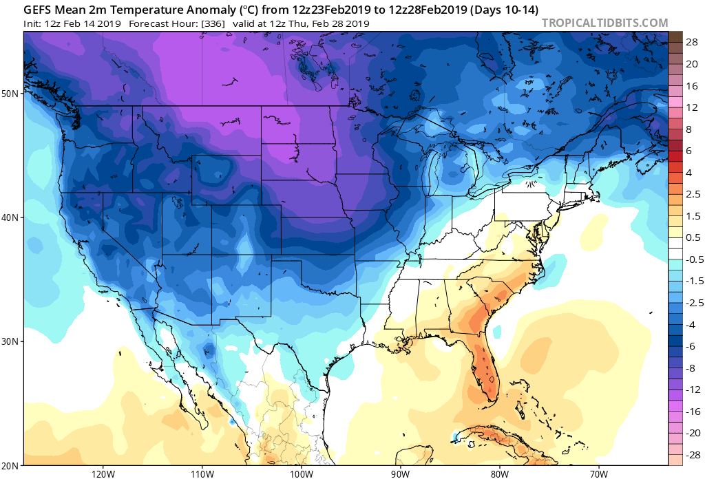
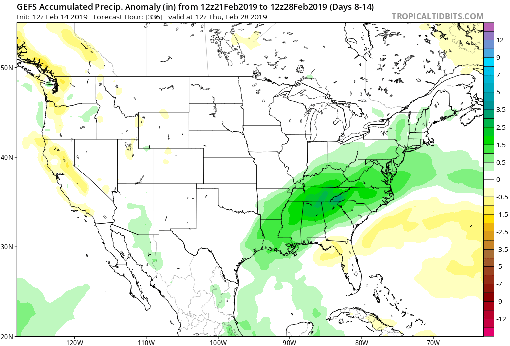
European Weekly Update
The new European Weeklies are in and follow the idea above nicely. They forecast a very stormy pattern to persist over the next few weeks with a battle ground between cold to our northwest and warmth to our southeast. We’ll have to be watchful for a couple of storm systems capable of delivering heavy amounts of precipitation. Given the teleconnection states over the next 6 weeks, it continues to look like any sort of significant wintry weather will need to take place before mid-March. Thereafter, warmer than normal times are expected, including true spring-like weather emerging. I know most can’t wait…
Permanent link to this article: https://indywx.com/2019/02/14/reviewing-the-latest-european-weeklies-and-updated-long-range-thoughts/
Feb 14
All-Access Morning Video Update: Looking Into Next Week & Reviewing The Latest JMA Weeklies…
You must be logged in to view this content. Click Here to become a member of IndyWX.com for full access. Already a member of IndyWx.com All-Access? Log-in here.
Permanent link to this article: https://indywx.com/2019/02/14/all-access-morning-video-update-looking-into-next-week-reviewing-the-latest-jma-weeklies/
Feb 13
Disruption In The Force Or Just Noise?
Our longstanding call has been for the period of early to mid-February to feature a “transitional” pattern before locking into one last cold, stormy period for the winter during the 2/18 through 3/10 time frame. The reasoning behind this idea has been stated multiple times in previous updates.
However, there’s no denying that today’s 12z ensemble update (both from the GEFS and EPS) has rattled us a bit with that idea. The GEFS and EPS are in very good agreement at 500mb:
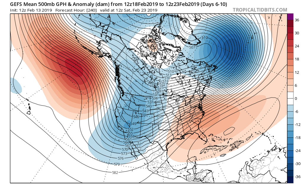
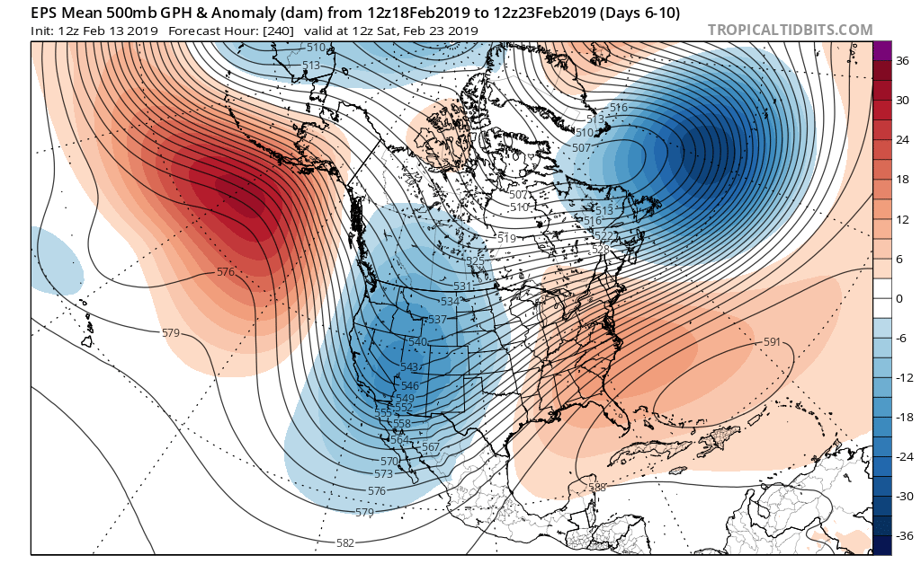
This is in the face of Phases 8 and 1 from an MJO perspective:
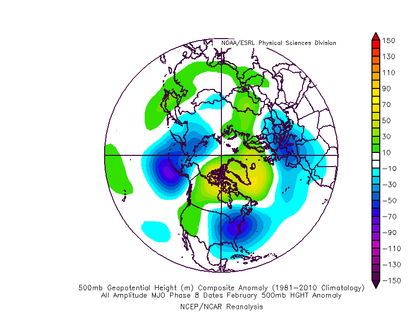

Furthermore, the sudden negative “jolt” in the SOI (Southern Oscillation Index) also favors a significant period of cold, stormy weather, locally:

Please understand this isn’t us changing our ongoing forecast that’s out there, but instead making sure we’re presenting a 100% transparent idea from two of the most highly respected ensemble products out there (that have been generating a lot of attention today with this output). We prefer to give it another few days before altering our medium and longer term forecast to see if any sort of consistency can develop.
At the end of the day, this may be a situation where the resistance from the SE ridge puts up enough of a fight to lead to a lack of “suppression” from the hyperactive storm track currently in place, and instead continuing the busy storm track into the TN and Ohio Valley regions as cold air presses.
Rest assured, you’ll be the first to know if a wholesale medium to long range forecast change is required here. Stay tuned.
Permanent link to this article: https://indywx.com/2019/02/13/disruption-in-the-force-or-just-noise/
Feb 13
All-Access Morning Video Update: Tracking 3 Storm Systems And An Overall Shift To A Colder Pattern…
You must be logged in to view this content. Click Here to become a member of IndyWX.com for full access. Already a member of IndyWx.com All-Access? Log-in here.
Permanent link to this article: https://indywx.com/2019/02/13/all-access-morning-video-update-tracking-3-storm-systems-and-an-overall-shift-to-a-colder-pattern/
