http:/
You must be logged in to view this content. Click Here to become a member of IndyWX.com for full access. Already a member of IndyWx.com All-Access? Log-in here.

Nov 19
http:/
You must be logged in to view this content. Click Here to become a member of IndyWX.com for full access. Already a member of IndyWx.com All-Access? Log-in here.
Permanent link to this article: https://indywx.com/video-update-on-the-remainder-of-this-week-and-at-some-thanksgiving-week-wintry-mischief/
Nov 17
Updated 11.17.13 @ 8:46pm
Zionsville, IN Sunday was a violent day across central Indiana, including multiple tornado touchdowns (Lebanon and Kokomo, for example), heavy rain (widespread 1″+ totals), and damaging straight line winds (numerous trees and power lines down across the region, fueled by 70-80 MPH wind gusts).
Thankfully the new work week will dawn with a much calmer weather pattern in place, albeit much cooler. High pressure will dominate our region, featuring dry and mostly sunny conditions both Monday and Tuesday. Monday will still be a bit breezy and we’ll note a stronger push of cold air arriving Monday night, setting the stage for a seasonably chilly Tuesday and Wednesday.
Our next weather maker will arrive as we wrap up the work week. The culprit will be a cold front blowing through the Hoosier state and while model data differs significantly on precipitation totals in the Thursday-Friday time period, we’re confident in rain falling followed by a big blast of cold air for the weekend.
Looking ahead to Thanksgiving week, the threat is there for some wintry “mischief” as southern branch low pressure attempts to attack the cold high to our north… We have plenty of time to watch this, but just make a mental note in the back of your mind for now as you prep for Thanksgiving holiday travel.
Monday: Mostly sunny; 40/ 51

Tuesday: Mostly sunny; 29/ 48
Wednesday: Increasing afternoon cloudiness; 30/ 51

Thursday: Cloudy and raw with rain likely; 43/ 49
![]()
Friday: Cloudy with rain likely; 44/ 49
![]()
Saturday: Mostly cloudy and colder; 30/ 39

Sunday: Mostly sunny and cold; 19/ 30
Permanent link to this article: https://indywx.com/monday-forecast-a-calmer-colder-week-ahead/
Nov 16
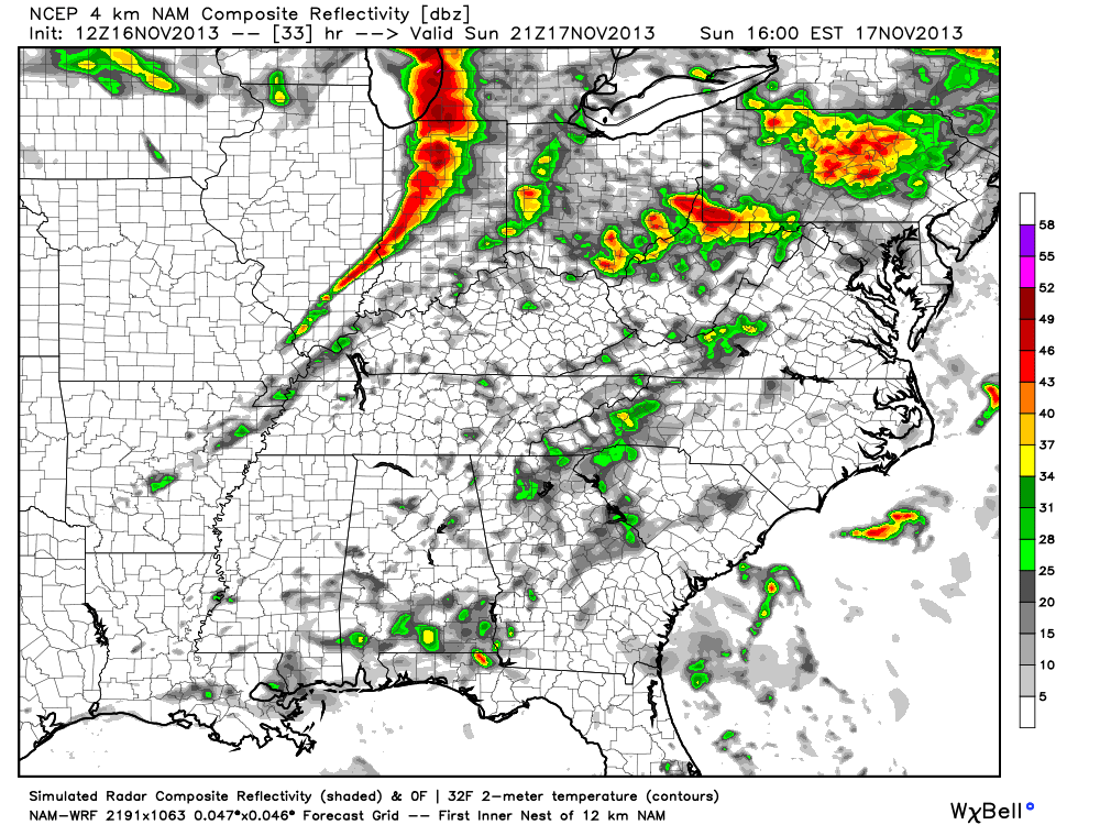
We continue to monitor Sunday’s severe weather outbreak very closely. Simply put, the latest data suggests all of central Indiana will be under the gun for a potentially dangerous and life threatening severe weather event Sunday. The bullet points highlighted in our previous post haven’t changed, but we note tornado parameters may be even more impressive per latest data. Unfortunately, I’m afraid multiple tornado touchdowns will be reported across central Indiana tomorrow afternoon, followed by a more widespread damaging straight line wind event mid to late evening. Certainly please keep abreast of the latest watches and warnings that will come tomorrow.
Showers and thunderstorms will develop tonight, but will remain below severe levels. The latest NAM simulated radar shows the developing showers and thunderstorms tonight.

Fast forward to Sunday evening and we note a line of severe thunderstorms moving through central Indiana, including a potential widespread damaging wind event.
Also, just to let you know, we’re also monitoring next weekend for another possible big weather event. This time we’re not talking severe weather, but possibly a major early season arctic attack… The latest European model isn’t holding back. Could a cold Thanksgiving week be shaping up? We’ll monitor closely.
Permanent link to this article: https://indywx.com/some-saturday-afternoon-thoughts/
Nov 13
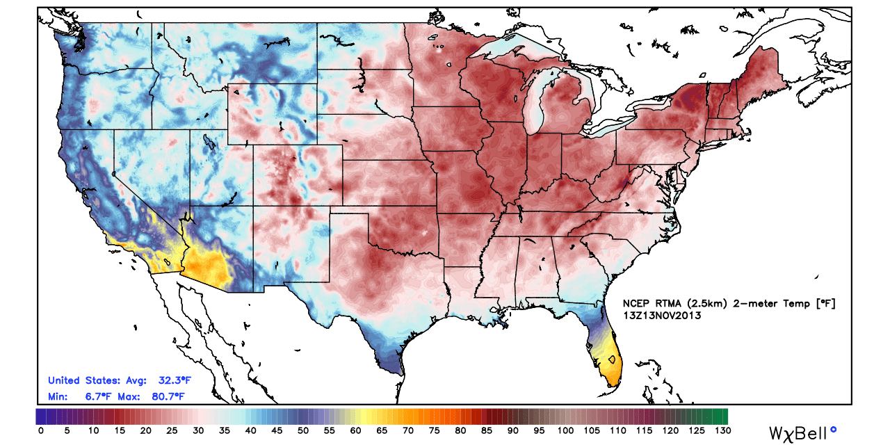
As I write this, many Hoosiers are awaking to temperatures at downright bitter levels, despite the fact it’s only mid November. The official low here at IndyWx.com HQ was a frosty 18 degrees and a far cry from the normal low of 37.
The early season bitter air mass has even settled in across portions of the Deep South and Coastal Plain. Amazingly, snow was reported along the Carolina coastline last night (almost unheard of for mid November). Note the deep freeze penetrating far into the Deep South. My home town of Auburn, AL dipped to a frigid 27 degrees this morning. Again, very rare for so early in the season.
It’s my job to look at what is behind these expansive early season bitter attacks of air (by the way, another bitterly cold air mass is ahead next week). In my opinion, a lot of the early shots of impressive arctic air has to do with the widespread early snow and ice pack developing across the Northern Hemisphere. We wrote about this first back on October 17th and the snow and ice pack has only been growing since. The latest image shows a very impressive and vast snow and ice pack for so early in the season. As early season cold moves south into the Lower 48, it doesn’t have much time to modify as it passes over the growing early season snow pack.

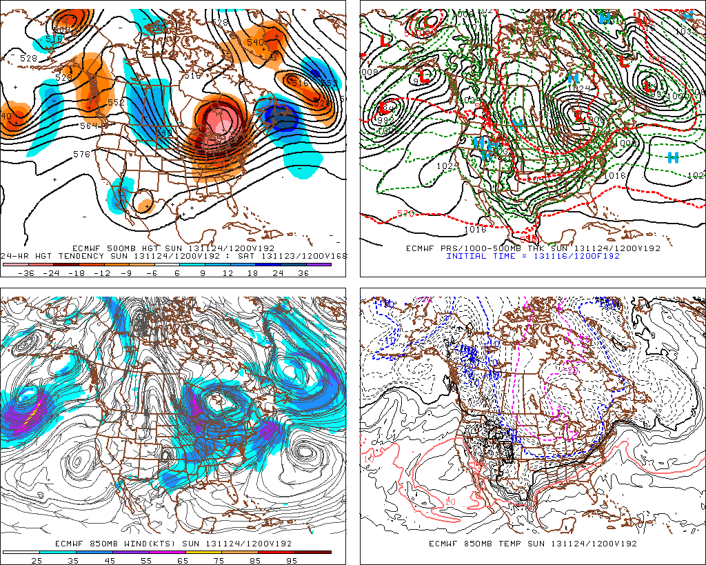
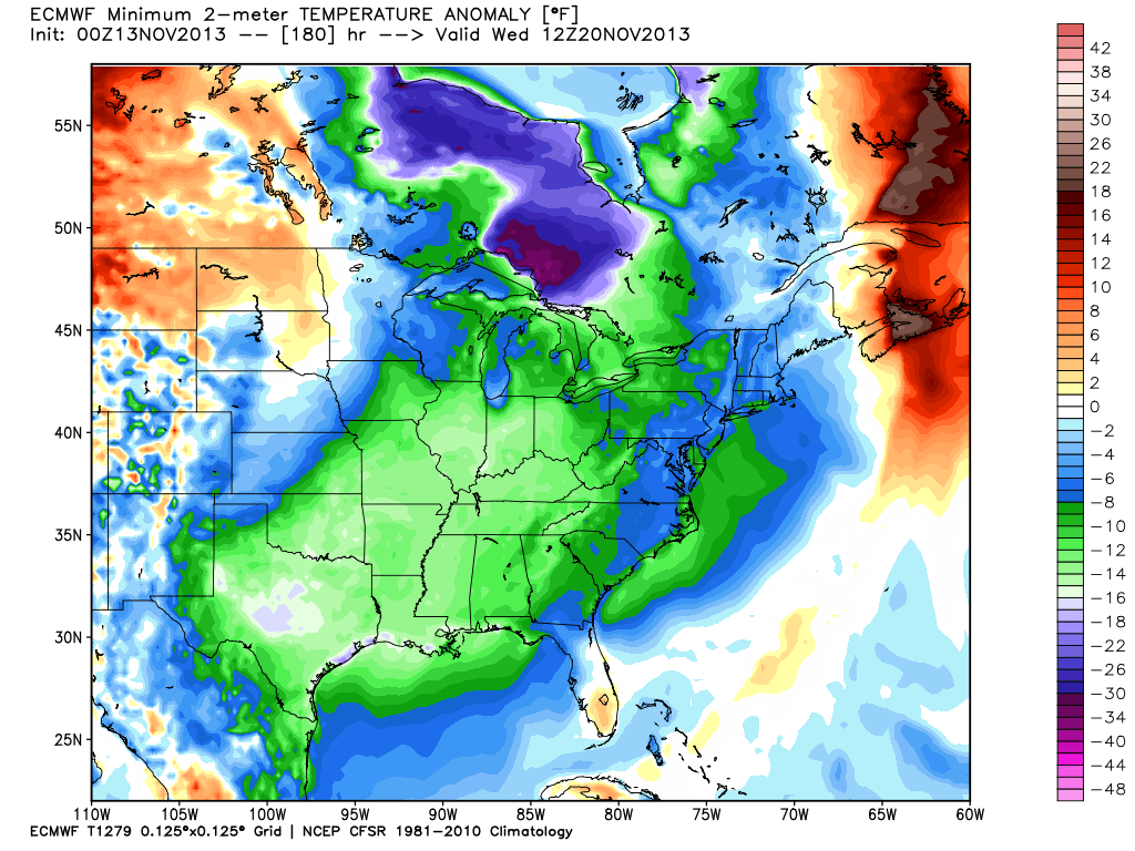
As we look ahead, despite the weekend warm-up, another impressive shot of arctic air will plow into the Hoosier state early next week (perhaps even colder than this current air mass). The European forecast model, once again, shows temperatures 12-18 degrees below normal by early next week.
Temperatures currently are running well below normal in similar areas modeling is sticking the “heart” of the cold next week.

As we continue rumbling into the colder, snowier months ahead, one has to at least wonder what the overall impact of the early season expansive snow and ice cover during October and November will leave on the winter of 2013-2014…
Permanent link to this article: https://indywx.com/no-secret-behind-the-early-bitter-shots-of-air/
Nov 12
Updated 11.12.13 @ 8:50p
Zionsville, IN After waking up to half an inch of snow, sunshine engulfed most of the region Tuesday. The vitamin D didn’t help temperatures moderate much as highs were more like mid to late December as opposed to mid November. We discuss a warming trend below, after a frigid start to your Wednesday.
Wednesday: Mostly sunny; 19/ 39
A strong area of high pressure will move overhead Wednesday and help supply a mostly sunny sky. Despite the sun, it’ll be another unseasonably cold day. Many outlying communities will begin the day in the upper teens before rising into the upper 30s to near 40 by afternoon- a solid 15 degrees below normal.
Thursday: Partly cloudy; 28/ 49
The same high pressure that will be directly overhead Wednesday will begin to move east Thursday. This will put our region in a southwesterly air flow and allow temperatures to begin moderating. After another cold start, highs will push towards the 50 degree mark Thursday afternoon.
Friday: Partly cloudy; 35/ 52
We’ll wrap the work week up with a few more clouds and temperatures still slightly cooler than normal, though much milder than those we’re dealing with now.
 Saturday: Turning cloudy with PM showers (0.20″); 40/ 59
Model data continues to hint at increasing clouds and the threat of afternoon light rain. We’ll initially have to overcome the dry air mass in place, but by afternoon/ evening we should have scattered showers beginning to impact central portions of the state.
![]() Sunday: Cloudy with rain likely (0.45″); 52/ 60
Sunday: Cloudy with rain likely (0.45″); 52/ 60
More widespread rain will arrive for the second half of your weekend. Highs will approach 60 and should we see any sunshine (not looking likely at this point), temperatures could go into the lower to middle 60s. While temperatures will be much warmer we’ll have to contend with rain Sunday.
![]() Monday: Showers and possibly a thunderstorm (0.50); 34/ 63
Monday: Showers and possibly a thunderstorm (0.50); 34/ 63
A strong cold front will blow through the state Monday evening. Out ahead of the front, an impressive surge of warmer and more humid air will move north and encompass central Indiana during the day. In fact, latest model data suggests dew points reach the lower 60s Monday. The combination between the warmer, more humid air in place and an impressive surge of arctic air behind the front could team up to produce a clap or two of thunder with the moderate to heavy rain threat Monday afternoon as the front moves through. Temperatures will then crash Monday night.
![]() Tuesday: Scattered snow flurries; 24/ 34
Tuesday: Scattered snow flurries; 24/ 34
The big story Tuesday will be the much colder air mass rushing into the state on strong and gusty northwest winds. Just enough moisture may linger to create the chance of scattered snow flurries.
Permanent link to this article: https://indywx.com/wednesday-forecast-a-bitterly-cold-start/