Dry, Chilly November Weekend; Mid Week Storms…
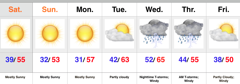
Screen Shot 2015-11-07 at 10.56.54 AMHighlights:

  • Sunny and cool
  • Midweek Storms
  • Prolonged period of windy weather late week

High pressure is building into the Ohio Valley this weekend and helping supply sunshine and that cool, crisp air we enjoy this time of year.  Freeze and frost conditions are ahead tonight and again Monday morning as high pressure moves overhead and results in clear skies and calm winds.

As the high moves to our east, a return SW flow will help moderate temperatures for mid week. As our next storm system comes out of the Plains it’ll intensify as it tracks into the Great Lakes.  Thunderstorms will accompany the cold front as it swings through the state Wednesday night.  We’ll monitor for strong to severe storm potential.  A lot will hinge upon the precise track of the surface low and we’ll keep a close eye on things over the next couple days.  We’ll turn cooler again late next week with strong winds shifting from the SW to NW.

Upcoming 7-Day Rainfall Forecast: 0.50″
Gusty Storms Followed By November Chill…

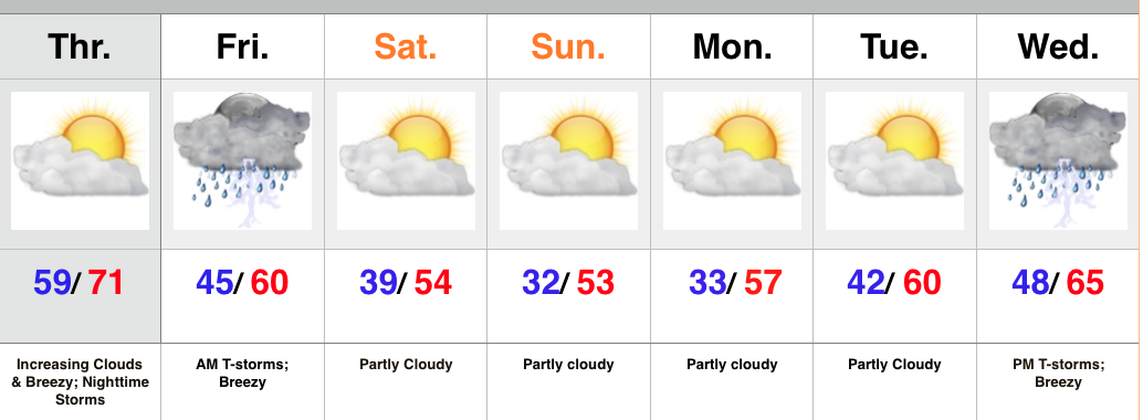
Screen Shot 2015-11-04 at 9.55.56 PMHighlights:

  • One more warm day
  • Gusty storms late tonight-Friday morning
  • Feeling more seasonal this weekend
  • Next storm arrives at the end of the period

High pressure will give way to an approaching cold front tonight.  Variably cloudy skies this morning will turn increasingly cloudy as the afternoon/ evening progresses.  Gusty SW winds will increase and gust over 20 MPH by afternoon.

The cold front will move through central IN early Friday morning and be preceded by a line of showers and embedded thunderstorms.  A few of these storms may contain strong winds, and this potential is something we’ll continue to keep a close eye on through the day Thursday.  Beneficial rains will also accompany the frontal passage.

The big story going into the weekend will be a much cooler, more seasonable feel, but sunshine will also be in our forecast.

Our next storm system of note appears to have eyes on the region by the middle of next week.

Upcoming 7-Day Rainfall Forecast: 0.5″ – 1″

Closer Look At Halloween Weather…

As we scan the latest computer models this morning we really see no reason to deviate from our forecast already out there on Halloween. While it shouldn’t be a complete…

You must be logged in to view this content. Click Here to become a member of IndyWX.com for full access.  Already a member of IndyWx.com All-Access?  Log-in here.

Thursday Morning Weather Rambles…

1.) We’re running 15°-20° colder this morning than this time yesterday. Wind chills in the upper 20s-lower 30s are being felt as winds remain gusty this morning.         2.)…

You must be logged in to view this content. Click Here to become a member of IndyWX.com for full access.  Already a member of IndyWx.com All-Access?  Log-in here.