Turning Stormy Later Tonight…
Screen Shot 2016-03-12 at 7.59.37 AMHighlights:

  • Turning stormy this weekend
  • Warm open to the week
  • Active times give way to a colder finish to the week

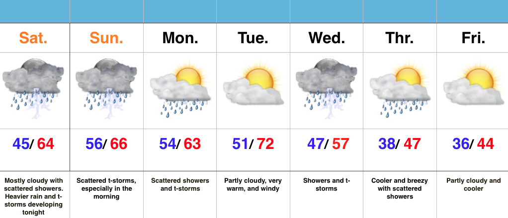
Thunderstorms Develop Tonight…A warm front is lifting through the state this morning and this could spark a few showers as it passes through central IN through the late morning hours.  Most of today will be dry before heavier rains and embedded thunderstorms push into the region tonight into Sunday morning.  By the way, don’t forget to set those clocks ahead an hour tonight ;-).

Rather unsettled weather will continue through the early and middle portions of the work week, but we caution timing is still up in the air.  It’s an active regime that will require fine tuning.  As things stand now, we forecast scattered showers and storms Monday and a mostly dry Tuesday.  Gusty SW winds will pull anomalous warmth into the region Tuesday before storms blow into the state late Tuesday night/ Wednesday.  This is in association with a cold front that will have things feeling much cooler around these parts to close the work week.

7-Day Precipitation Forecast:

  • Snowfall: 0.00″
  • Rainfall: 1.25″ – 1.75″ (locally heavier totals)
Interested in more in-depth long range forecast discussions, video updates, ag. forecasts, and seasonal outlooks? E-mail bill@indywx.com for more information.

Snow Transitions To Rain…

Screen Shot 2016-03-03 at 7.11.27 AM

Highlights:

  • Snow changes to rain
  • Dry close to the work week
  • Warm, but wet pattern develops next week

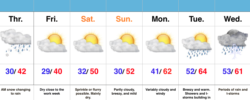
Snow Transitions To Rain…Snow spread over central IN during the overnight and most neighborhoods accumulated between 1″-2″.  Warm air advection will result in snow transitioning to rain from south to north as we progress through the late morning hours.  All in all, it’ll be a raw Thursday.

Weak high pressure will build in and result in dry conditions Friday with sunshine returning.

A fast moving system will clip the region Saturday with a sprinkle or flurry possible, but this doesn’t appear to be a big deal in the least.

The bigger story?  The developing unseasonably warm period developing next week, but we caution this will also be a wet period as a prolonged SW flow transports moisture-rich Gulf of Mexico air into the region.  Heavy rain totals will be a good bet.

Slushy Snow Late Tonight For Some…

Screen Shot 2016-03-02 at 7.32.36 AMHighlights:

  • Cold, dry midweek
  • Snow changes to rain for central IN Thursday morning
  • Much warmer times coming

Slushy Snow Late Tonight For Some…It’s a much colder feel out the door this morning!  You’ll want the heavier coat.  The good news? Dry conditions today, including lots of sunshine.

Our next fast moving storm system will spread snow into central IN during the overnight (after midnight for most) and accumulate for some (snowfall forecast below).  For the city, itself, look for a slushy coating to 1″.  Further north, a band of 1″-3″ is expected before the transition to rain mid to late morning.  Northern IN will be the “winner” with this system, including a 3″-5″ band.  All precipitation will be to our east by Thursday evening.

A dry close to the work week is expected before another fast moving storm system deliver a sprinkle Saturday, but this just doesn’t look to be a big deal at the moment.  We’ll keep an eye on things.

We turn much warmer early next week, but clouds and showers may keep us from being as warm as we could’ve been otherwise.  Better rain and storm chances arrive late Tuesday.  A stiff southwest wind will be with us early next week.

Thursday3:3:16For more in-depth and frequent video discussions and long-range forecasts, e-mail bill@indywx.com for details on our consulting options.