Category: Unseasonably Cool Weather

Weekend Snow Storm On Deck And A Word On February…

First, enough energy needed out of the SW is going to come out and lead to a widespread snow storm from the central Plains through the Ohio Valley.  Here on the…

You must be logged in to view this content. Click Here to become a member of IndyWX.com for full access.  Already a member of IndyWx.com All-Access?  Log-in here.

Permanent link to this article: https://indywx.com/weekend-snow-storm-on-deck-and-a-word-on-february/

Now This Is More Like It…

Screen Shot 2015-01-28 at 7.30.19 AMMaking Up For Lost Time…Many snow lovers out there have been disappointed by the lack of the white stuff winter to date.  The cool thing is that the next 7-10 days (most likely longer) will offer up multiple opportunities to serve up accumulating snow.

First things first and that’s today- look for bright sunshine and a frosty start.  Temperatures will “warm” to just under seasonal levels this afternoon.  A fast moving storm system will scoot through here late tonight and Thursday morning with light rain, possibly transitioning to light snow showers before precipitation ends Tuesday (not a big deal).  Far eastern areas may experience a brief period of light freezing rain or light sleet during the onset of precipitation, but things should switch over to light rain rather rapidly even for you.  We’ll turn dry and cold to wrap up the work week.

All eyes are on the weekend as a storm system moves towards the region.  We have a ways to go and we’ll have to fine tune the details over the next few days, but this has potential to be the most widespread significant wintry event of the season.  Stay tuned.  MUCH colder air will punch in here early next week and may set the stage for more wintry “mischief” by the middle of next week.

ISRlogo2-280x121IU at Purdue: 9p tonight

Good news is that for those driving to West Lafayette tonight, you should be dealing with dry conditions.  Precipitation chances will begin to go up as we near 11p, or after, for western portions of the state.

Upcoming 7-Day Precipitation Forecast:

  • 7-Day Rainfall Forecast: 0.25″
  • 7-Day Snowfall Forecast: 3″ – 6″

Permanent link to this article: https://indywx.com/now-this-is-more-like-it-2/

So Long Boring Weather…

Screen Shot 2015-01-24 at 8.49.04 AMBusy Times In The Forecast Office…Let’s get to the easy part of this forecast package and that’s today.  Look for lots of sunshine along with seasonably mild temperatures after a cold and frosty start.

Things get fun tomorrow as a clipper low dives southeast and tracks in a favorable position for accumulating snow- especially from the city and points north (snowfall forecast below).  A mixture of rain and snow will overspread central Indiana Sunday morning and transition to all snow through the late morning into the early afternoon.  This will be a heavy, wet snow (perfect for snowball fights or making a snowman).  The other aspect to this storm system will be an increasing east and northeast wind Sunday evening into Monday morning.  Snow will diminish Sunday night, but the “damage” will likely be done by that point, leaving a mark on your Monday morning commute.

Another (weaker) weather maker may deliver scattered snow showers Tuesday.

Briefly milder air will move in here Thursday with a mixture of rain, snow, and sleet (depending on where you’re viewing us through the state), but the bigger story will be MUCH colder air set to pour into the region to close January and open February.  Some forecast models suggest a winter storm will precede the bitterly cold air around Super Bowl Sunday…. Stay tuned.

Upcoming 7-Day Precipitation Forecast:

  • 7-Day Snowfall Forecast: 2″ – 5″
  • 7-Day Rainfall Forecast: 0.10″ – 0.25″

12515SnowfallMap

Permanent link to this article: https://indywx.com/so-long-boring-weather/

Step Down Process To Cold Before The Return Of Truly Frigid Times…

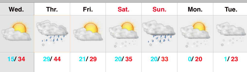
The past 5-7 days have featured a common “January thaw-” something typically seen in even the coldest Januarys.  The coming 5-7 days will see a “step down” process of colder weather, interrupted by a day or two of milder southwest breezes.  In the longer range, we hold firm on the idea of more sustained cold, and potentially frigid air, setting up shop to open February.

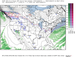
See the GFS track the clipper through the lower lakes this weekend.  This is a mild track for central Indiana and will keep the accumulating snows over the Lakes region, extending into northern portions of the state.  Some light snow will fly here late Sunday night/ early Monday, but accumulations should be minimal.

gfs_ptype_slp_conus2_12

gfs_ptype_slp_conus2_16
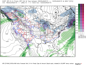
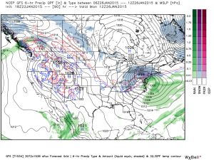
A brief surge of arctic air will invade early next week and may be accompanied by light snow Tuesday.

gfs_ptype_slp_conus2_21
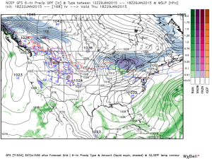
A brief southwesterly flow will allow milder air into the region by the middle of next week, but we caution this will be brief.

gfs_ptype_slp_conus2_29
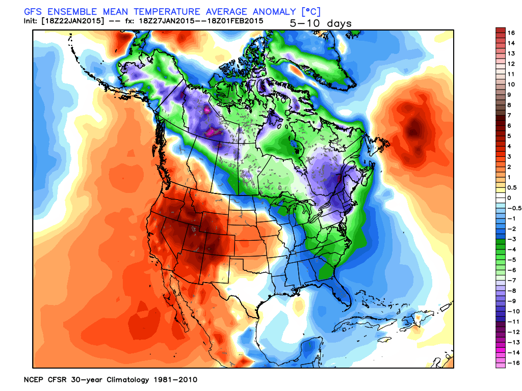
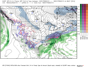
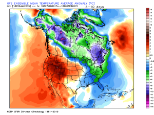
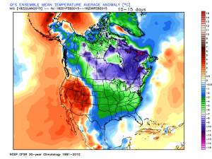
Much colder times loom to open February, potentially with a winter storm.  Obviously with this being in the 8-10 day period, there will be a lot of time to watch the storm potential.  Models have struggled mightily with storms this winter so far.  We’re much more confident on the cold, and potentially downright frigid air at that (still don’t think we’ve seen the coldest air of the winter yet).  Note the GFS sees the arctic highs “lining up.”

gfs_ptype_slp_conus2_41The European ensembles and operational are also keying in on the cold and wintry pattern closing January and to open February:

Geopotential32at32500hPa_North32America_216
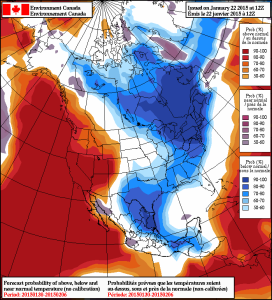
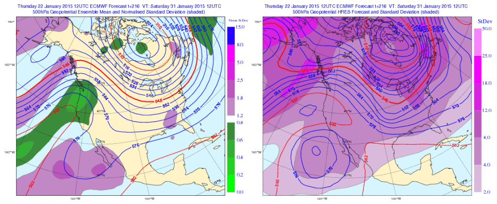
Initially the cold attacks the northeastern portions of the country, but “backs” west with time in the longer range:

Days 5-10

1Days 10-15

2
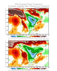
The NAEFS and CFSv2 see the colder pattern returning:

2015012212_054@007_E1_north@america_I_NAEFS@TEMPERATURE_anomaly@probability@combined@week2_186

wk1.wk2_20150122.NAsfcT

We still think there’s a lot of “winter” left in the coming months.  Many folks enjoy snow Christmas into January, but begin to crave spring in February and March.  This is the type pattern that can be quite “ugly” for spring lovers as colder and snowy weather can push well into the spring months…  (Noted that we still have a lot of catch up to do in the snow department, but we’re not ready to say we won’t make up for “lost time”).

Permanent link to this article: https://indywx.com/step-down-process-to-cold-before-the-return-of-truly-frigid-times/

Colder, But Nothing Drastic…

Screen Shot 2015-01-21 at 6.28.17 PM

Colder, But Nothing Too Out Of The Ordinary…A colder theme will be with us as we put a wrap on the work week.  That said, temperatures will actually be much closer to where they should be for this time of the year.  A quiet weather pattern will continue until we watch a clipper system for the second half of the weekend.  As of now, the accumulating snow looks to stay north of our immediate region, but we’ll keep a close eye on it.  Officially, we’ll call for increasingly cloudy skies Saturday night into Sunday morning with scattered rain showers Sunday afternoon changing to snow showers Sunday night before ending. If traveling north, prepare for several inches of snow across northern portions of the state into the Great Lakes region.  Stay tuned as this system is still a few days off and changes can take place moving forward.  Colder air follows for early next week.

Upcoming 7-Day Precipitation Outlook:

  • 7-Day Rainfall Forecast: 0.10″ – 0.20″
  • 7-Day Snowfall Forecast: Dusting

Permanent link to this article: https://indywx.com/colder-but-nothing-drastic/