VIDEO: Severe Weather Sunday; Wintry Push In The Week Ahead…
You must be logged in to view this content. Click Here to become a member of IndyWX.com for full access. Already a member of IndyWx.com All-Access? Log-in here.
You must be logged in to view this content. Click Here to become a member of IndyWX.com for full access. Already a member of IndyWx.com All-Access? Log-in here.
 Highlights:
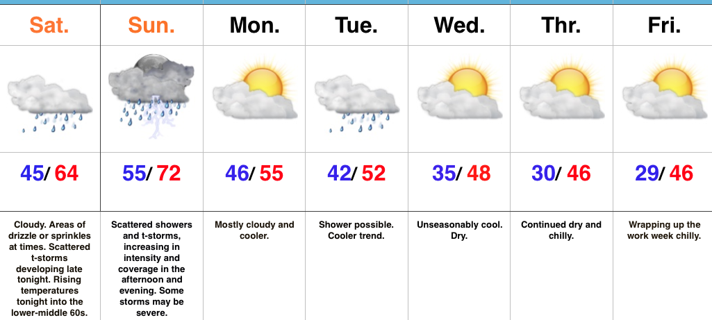
All Eyes On Sunday…The cold front that passed through the region Thursday night and setup the gorgeous close to the work week is lifting back north this morning as a warm front. This will result in overcast conditions today, areas of sprinkles or drizzle later in the day, and rising nighttime temperatures. Scattered thunderstorms will develop across central Indiana late tonight with a warmer and increasingly moist environment.
Sunday will certainly be a day to remain weather-aware. The overall setup hasn’t changed from what was discussed yesterday with a warm and moist southwesterly air flow in place ahead of an approaching cold front and associated area of low pressure. Additional ingredients in play suggest we need to monitor the threat of large hail, damaging straight line winds, and potentially tornadoes. Individual storms (potential super cells) are expected to fire across central and northern portions of the state Sunday afternoon into early evening. These will be capable of quickly pulsing to severe levels and include potential of large hail, as well as tornadoes (particularly in the vicinity of the warm front which is expected to be draped across north-central parts of the state). Individual cells are anticipated to “morph” into a squall line Sunday evening, including potential of a quick spin-up tornado, as well as damaging straight line winds. With a moisture-rich air mass in place (precipitable water values are expected to approach 2″ Sunday evening), locally heavy rainfall is also expected.
All of our “excitement” will come to an end overnight Sunday and we’ll trend much colder (and calmer) during the new work week ahead. Our next storm system will pass by to our south Tuesday, but may be close enough to spark a light shower across central portions of the state. Drier and colder conditions build in later in the week.
Upcoming 7-Day Precipitation Forecast:
We have growing concerns of a severe weather event Sunday afternoon and evening across the state. This morning, the Storm Prediction Center (SPC) has included most of Indiana in an “Enhanced” risk of severe weather. From this distance, all modes of severe weather seem possible, including large hail, damaging winds, and even a tornado or two.
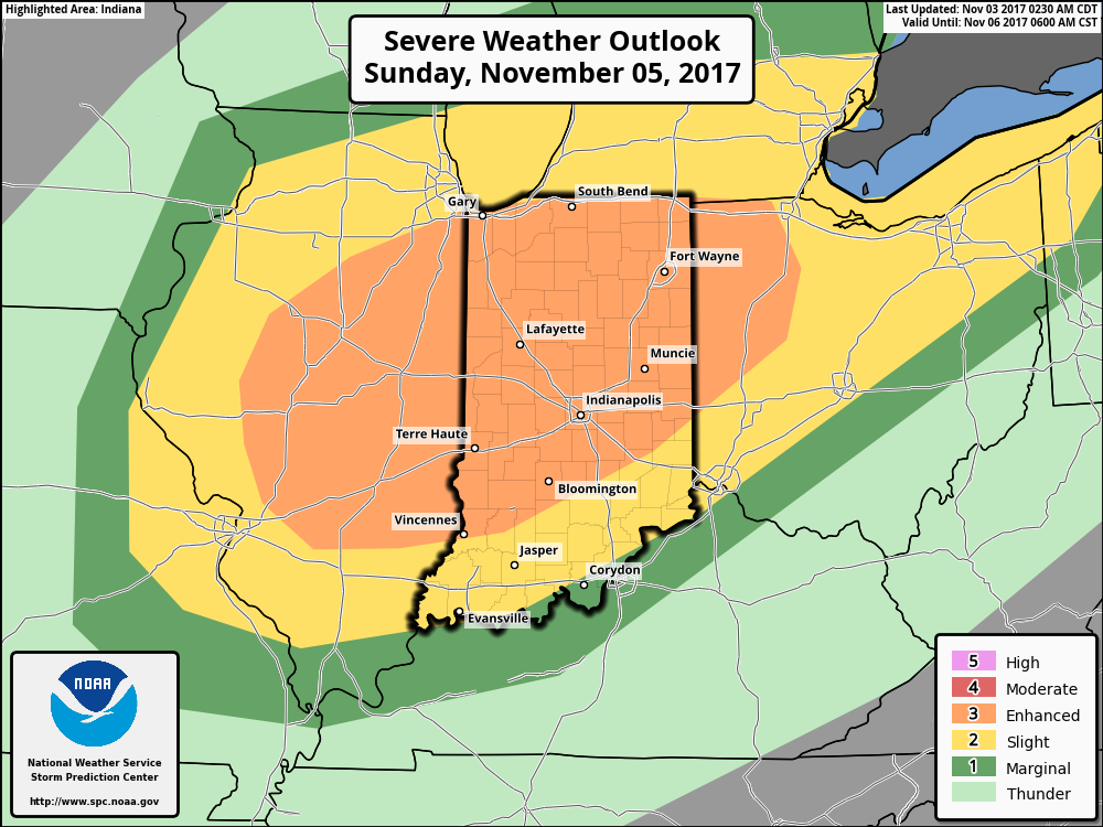 A trough and associated cold front will slice into an unseasonably warm and increasingly moist air mass Sunday. Ahead of the approaching front, temperatures should climb into the lower 70s Sunday afternoon (average high is in the upper 50s) and dew points will reach the lower to middle 60s. While the developing surface low isn’t expected to be terribly strong, as this feature moves northeast, it’ll help drag a cold front into this warm and increasingly unstable air mass late Sunday. From this distance, conditions seem favorable for a couple of super cells to develop Sunday afternoon and evening. We’ll have to keep a close eye on the northward extent of the warm front as this would be the areas of greatest concern for potential tornadic activity Sunday afternoon. Large hail and damaging winds are also included in Sunday’s severe threat. We’re in the second severe weather season, after all, and this kind of event isn’t unusual. Late November 2013 comes to mind.
It’ll be important to remain weather-aware Sunday and stay tuned all weekend for future updates. We’ll transition to a much cooler regime (back to below average) next week.

 Highlights:
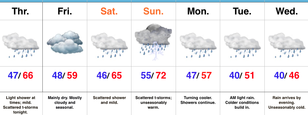
Vitamin D Needed…While we’re going through a milder stretch of weather between now and the end of the weekend, it’ll come with considerable cloudiness and periods of rain at times.
Most of today will only feature light passing showers and mist, but a clap or two of thunder can be expected tonight as a cold front passes through the state. The air mass behind the front won’t be particularly cold and a seasonable day is on tap to wrap up our work week Friday.
A warmer southwesterly air flow will return this weekend and this will help boost temperatures to levels as much as 15° above average Sunday. Scattered showers can be expected Saturday into Sunday and we’re monitoring the potential of a stronger storm Sunday afternoon and evening. You’ll want to stay tuned for future updates on Sunday’s storm threat.
As we rumble into a new work week, the active and wet pattern will continue and we’ll add a colder feel to the equation, as well. Monday through Wednesday will feature a “step down” regime: seasonable conditions Monday before turning colder than normal Tuesday and Wednesday.
Upcoming 7-Day Precipitation Forecast:
You must be logged in to view this content. Click Here to become a member of IndyWX.com for full access. Already a member of IndyWx.com All-Access? Log-in here.