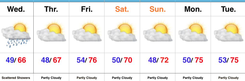
Category: Unseasonably Cool Weather

More Dry Time Than Not, But Keeping A Close Eye On Storm Chances…

Highlights:

  • Much more dry time than stormy
  • Timing storm chances
  • Unseasonably cool open to June

Best Storm Chances Arrive Overnight…Low clouds and areas of fog should dissipate and give way to partial sunshine as we progress into the late morning and afternoon hours.  A warm and humid feel will develop this afternoon.

The majority of the long race and holiday weekend will be free of any rain and storms, but we will continue to keep a close eye on the potential of more widespread storm activity:

Overnight tonight into early Sunday morning and again Sunday afternoon.

Data would place more emphasis on the potential of widespread severe weather across southern parts of the state tonight.  Damaging wind and hail are the primary concerns.  Additionally, as a cold front rumbles into the warm and moist airmass in place Sunday afternoon, additional strong to severe storms may develop.  These will be more scattered in nature when compared to the overnight round of storms, but any one particular neighborhood across central Indiana is fair game for getting wet for a brief time Sunday afternoon.

The cold front will sweep through the state Sunday evening and usher in a less humid and pleasant Memorial Day.  We’ll keep an eye on Tuesday into Wednesday for shower chances, but think we’ll remain mostly rain-free.  The region will be under a fast-paced northwest flow aloft and models can struggle with specifics associated with weak disturbances in that northwest flow.  The next chance of storms arrives Friday, along with a warmer feel.

Upcoming 7-Day Precipitation Forecast:

  • Snowfall: 0.00″
  • Rainfall: 1.00″ – 1.50″

Permanent link to this article: https://indywx.com/more-dry-time-than-not-but-keeping-a-close-eye-on-storm-chances/

Pleasant Weather Later Today; Unsettled Conditions Return…

Highlights:

  • Rain ends and sunshine arrives later today
  • Pleasant Carb Day
  • Stormy at times this weekend

Trend Is Our Friend Today…Showers are “pinwheeling” around an area of low pressure to our east this morning, but these will begin to diminish as we move through the late morning and into the early afternoon.  In fact, we think sunshine works in here later this afternoon and provides a pleasant finish to the day!

The majority of Friday will feature sunshine and pleasantly warm conditions by afternoon.  We’ll keep a close eye on the radar Friday evening/ night, but currently believe thunderstorms will remain just north of here.

Unfortunately, the long race and Memorial Day weekend won’t be rain-free, but it also won’t be a wash-out.  Most widespread thunderstorm activity should arrive Saturday evening into Sunday morning and some of these could become strong to severe.  The current Day 3 (Saturday) Outlook from the Storm Prediction Center places central and southern portions of the state under a Slight Risk.

While we can’t completely rule out an afternoon shower or storm Sunday, the most widespread activity should occur during the morning hours- before race time. Stay tuned.  We’ll turn cooler early next week…

Upcoming 7-Day Precipitation Forecast:

  • Snowfall: 0.00″
  • Rainfall: 1.25″ – 1.75″

Permanent link to this article: https://indywx.com/pleasant-weather-later-today-unsettled-conditions-return/

Cool And Increasingly Wet Today…

The morning is starting off dry across most of central Indiana, but that will begin to change as we progress into the afternoon and evening hours as rainfall grows in coverage and intensity.

10a forecast radar

2p forecast radar

Widespread rain will continue tonight as low pressure tracks north out of the TN Valley and slowly meanders across eastern IN and OH tonight before pulling off to the northeast Thursday.

Thankfully, rain will begin to diminish Thursday morning and we’re back to mostly dry conditions by Thursday afternoon.  Before dry weather returns, some neighborhoods can expect to accumulate between 1″-2″ of rain.

With the clouds and showers around, expect unseasonably cool conditions both today and Thursday.  Highs will only reach the mid to upper 60s both days.

As we look ahead, we think our dry Thursday afternoon should continue into most of Friday before scattered showers and thunderstorms return to the forecast Saturday and Sunday.  More on those details later today!  Make it a great Wednesday!

Permanent link to this article: https://indywx.com/cool-and-increasingly-wet-today/

VIDEO: Unsettled Weather Returns For Midweek And Looking Ahead To Race Day Weather…

You must be logged in to view this content. Click Here to become a member of IndyWX.com for full access.  Already a member of IndyWx.com All-Access?  Log-in here.

Permanent link to this article: https://indywx.com/video-unsettled-weather-returns-for-midweek-and-looking-ahead-to-race-day-weather/

Busy Week Of Weather…

Highlights:

  • Sunny open to the work week
  • Midweek storms
  • Storm chances remain for the long race and holiday weekend ahead

Pleasant Open To The Work Week…High pressure will support dry and pleasant weather conditions as we open up the work week. Expect plentiful sunshine and comfortable conditions to spend time outdoors today!  Enjoy!

Unsettled weather will return for midweek as low pressure moves into the Ohio Valley.  Scattered showers Tuesday will increase in overall coverage and intensity Wednesday, including the potential of locally heavy rainfall.  With all of the clouds and rain around through midweek, temperatures will run significantly below average.

Thankfully, we’ll get a breather Friday, with a mostly dry day expected.  We’ll turn the temperature up a couple notches heading into the long race and Memorial Day weekend.  Additionally, expect an increasingly muggy feel with scattered thunderstorms returning to the forecast this weekend.

Upcoming 7-Day Precipitation Forecast:

  • Snowfall: 0.00″
  • Rainfall:  1.50″ – 2.00″

Permanent link to this article: https://indywx.com/busy-week-of-weather/