Updated 05.03.23 @ 7:28a
You must be logged in to view this content. Click Here to become a member of IndyWX.com for full access. Already a member of IndyWx.com All-Access? Log-in here.

May 03
Updated 05.03.23 @ 7:28a
You must be logged in to view this content. Click Here to become a member of IndyWX.com for full access. Already a member of IndyWx.com All-Access? Log-in here.
Permanent link to this article: https://indywx.com/2023/05/03/video-keeping-close-eye-on-northern-extent-of-rain-friday-night-otherwise-a-nice-weekend-on-deck/
May 02
Updated 05.02.23 @ 7:58a
You must be logged in to view this content. Click Here to become a member of IndyWX.com for full access. Already a member of IndyWx.com All-Access? Log-in here.
Permanent link to this article: https://indywx.com/2023/05/02/video-big-weekend-improvements/
May 01
Updated 05.01.23 @ 7:39a
You must be logged in to view this content. Click Here to become a member of IndyWX.com for full access. Already a member of IndyWx.com All-Access? Log-in here.
Permanent link to this article: https://indywx.com/2023/05/01/video-its-not-about-how-you-start-but-how-you-finish/
Apr 30
Updated 04.30.23 @ 10:04a
You must be logged in to view this content. Click Here to become a member of IndyWX.com for full access. Already a member of IndyWx.com All-Access? Log-in here.
Permanent link to this article: https://indywx.com/2023/04/30/video-cold-raw-open-to-may-mid-month-pattern-change-on-the-horizon/
Apr 29
Updated 04.29.23 @ 8:50a
You must be logged in to view this content. Click Here to become a member of IndyWX.com for full access. Already a member of IndyWx.com All-Access? Log-in here.
Permanent link to this article: https://indywx.com/2023/04/29/video-unsettled-and-chilly-pattern-midweek-frost/
Apr 28
Updated 04.28.23 @ 2:33a
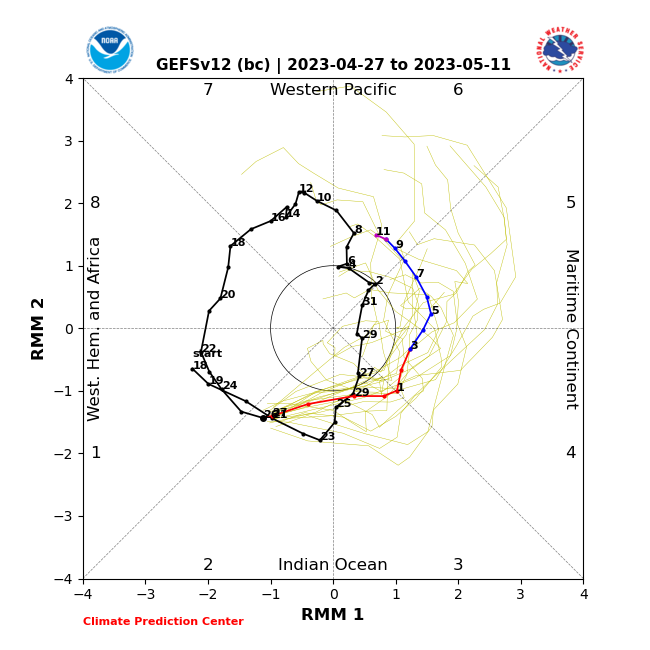
While we remain bullish on a warmer response in the Week 2-3 time period, the longevity of any sort of “warm-up” is the point we’re trying to drive home. The MJO is still forecast to amplify into Phase 6 just past May 10th. As a result, our stubborn call remains on modeling being “forced” to correct warmer during this time.
As it is, we’re in a camp of our own with that call based off Thursday’s long range update. Note both the new European Weeklies and JMA Weeklies show the eastern trough remaining.
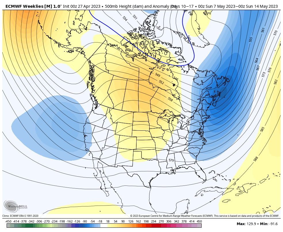

At the very least, it’s an interesting test case on our hands that we’ll be able to see play out in real time.
Even if we do see the Week 2-3 warm up, it’s likely to be short-lived as the MJO continues to rumble into cooler phases and the teleconnections (namely the EPO and NAO) tag-team neutral to negative through the bulk of May and into early June.
The end result after any sort of warmer response during the aforementioned time period is likely for at least a slightly cooler pattern to return compared to average. The relatively drier pattern will also trend wetter late May into early June.


At the end of the day, we still see a warmer surge taking hold, locally, between Weeks 2-3. However cooler and wetter conditions likely settle back in as we navigate the back half of May and into early June at least.
Is this a hint of the times as summer matures? Not out of the question this year as we flip the page to Nino conditions…
Permanent link to this article: https://indywx.com/2023/04/28/lr-update-may-pattern-evolution-and-early-look-at-june/
Apr 27
Updated 04.27.23 @ 2:07a
May will open with a continuation of unseasonably chilly weather. We’re even looking at the potential of an additional frost threat early next week.
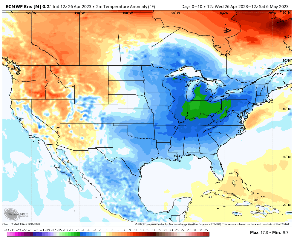
But there are changes in the offing just beyond the 10th, or so. The NAO trends neutral.
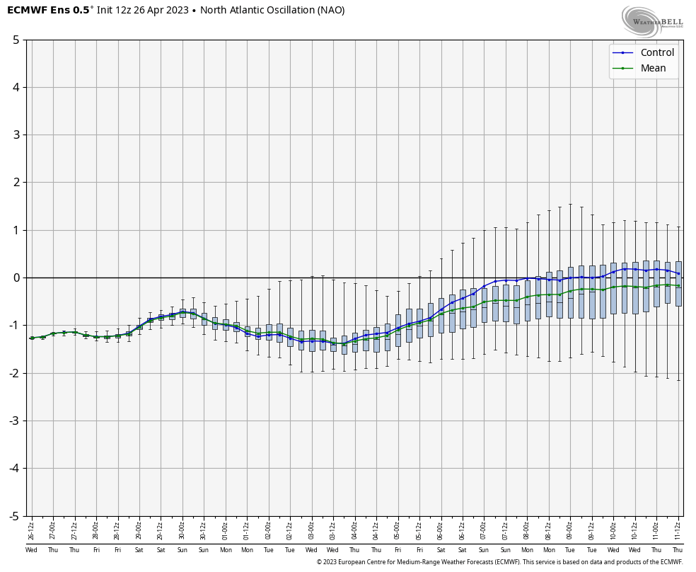
And the Madden-Julian Oscillation (MJO) is heading towards the balmy (for May standards) Phase 6.

While there will be some questions with respect to the longevity of the warm-up, we should see a notable flip in the pattern just beyond the first 1/3 of the month, including much warmer weather across our neck of the woods and a good chunk of the east as a whole.
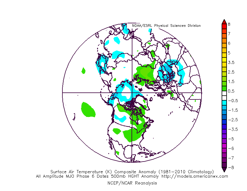
I would anticipate models to trend warmer in that Weeks 2-3 timeframe over the course of the next couple of days.
Permanent link to this article: https://indywx.com/2023/04/27/more-rumblings-around-the-mid-may-pattern-change/
Apr 26
Updated 04.26.23 @ 6:44a
Today and Thursday morning are “easy peasy.” Look for dry times and plentiful sunshine today giving way to increasing clouds Thursday morning.
Those clouds will give way to a shield of rain lifting from our southwest to northeast late Thursday morning into Friday morning, courtesy of an initial wave of low pressure moving into the Ohio Valley.

Generally, heaviest rain within this time period will fall across southeast Indiana.
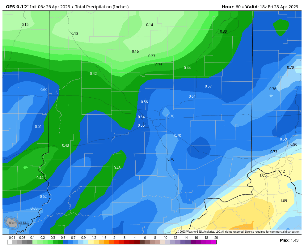
Amounts of a half inch (locally heavier) seems like a good call as far northwest as Indianapolis and surrounding ‘burbs.
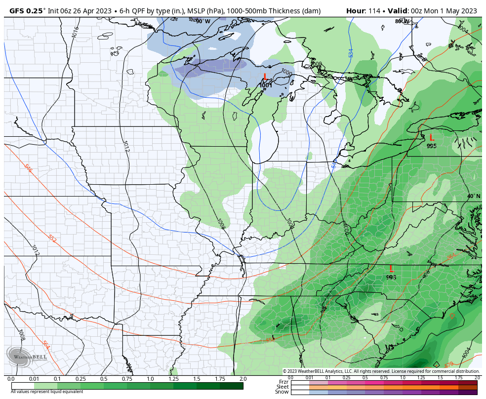
As we head into the weekend the trend will once again be a cooler one, with the emphasis placed on the 2nd half of the weekend for the coolest air and more unsettled conditions (showery nature but nothing heavy expected). 60s Saturday will be replaced with 50s Sunday. Eventually, as skies clear and winds calm, another opportunity for frost looms Monday or Tuesday morning of next week as lows fall into the middle 30s.
Permanent link to this article: https://indywx.com/2023/04/26/evolution-of-things-into-early-next-week/
Apr 25
Updated 04.25.23 @ 7:48a
You must be logged in to view this content. Click Here to become a member of IndyWX.com for full access. Already a member of IndyWx.com All-Access? Log-in here.
Permanent link to this article: https://indywx.com/2023/04/25/video-active-times-more-pronounced-pattern-shift-come-mid-may/
Apr 24
Updated 04.24.23 @ 7:53a
You must be logged in to view this content. Click Here to become a member of IndyWX.com for full access. Already a member of IndyWx.com All-Access? Log-in here.
Permanent link to this article: https://indywx.com/2023/04/24/video-weak-system-tuesday-morning-followed-by-something-more-significant-this-weekend/