Bitter Cold Today Gives Way To Rain Tuesday Evening; Wintry Close To The Week…
You must be logged in to view this content. Click Here to become a member of IndyWX.com for full access. Already a member of IndyWx.com All-Access? Log-in here.
You must be logged in to view this content. Click Here to become a member of IndyWX.com for full access. Already a member of IndyWx.com All-Access? Log-in here.
You must be logged in to view this content. Click Here to become a member of IndyWX.com for full access. Already a member of IndyWx.com All-Access? Log-in here.
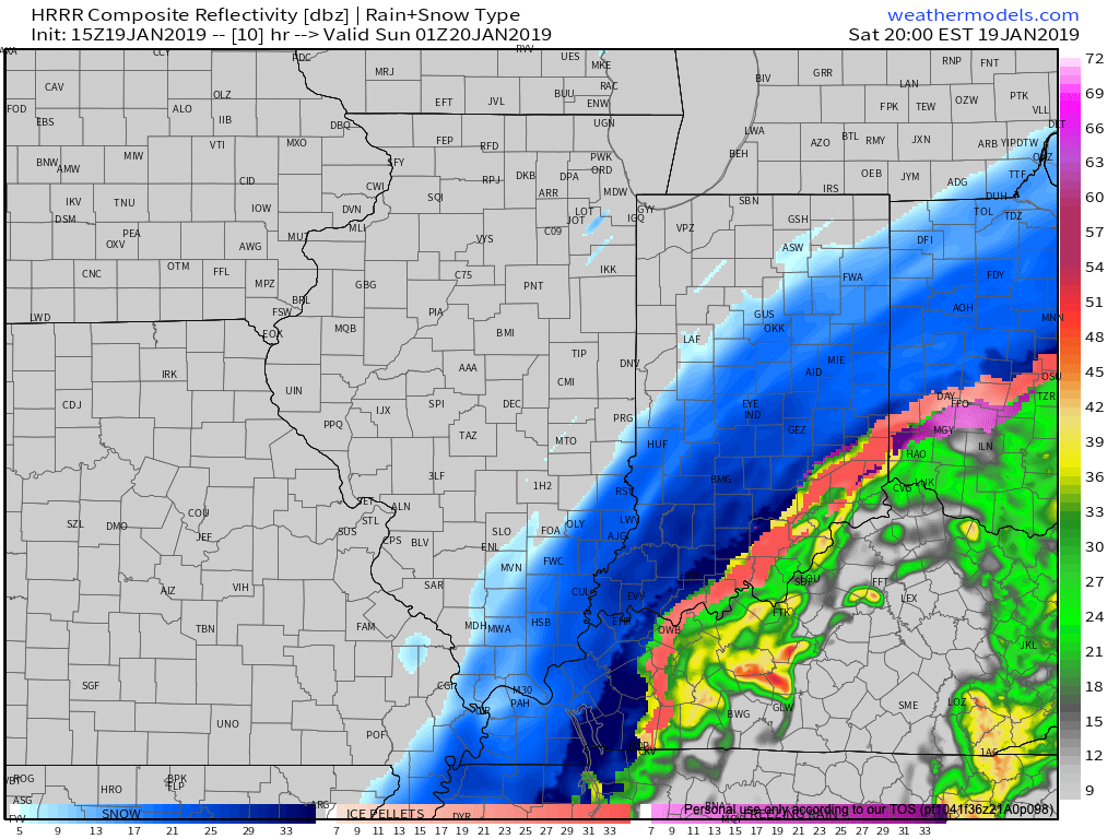
While warm air advection (WAA) created an added challenge this morning (freezing rain north of the city, itself, and rain south of I-70), colder air is working south late this morning and will result in a changeover from freezing rain/ rain to snow over the next couple hours from north to south.
We expect the transition to snow to take place in and around Indianapolis between 1p and 2p.
 As upper level energy tracks northeast this evening, strong frontogenesis will help a “deformation band” expand in coverage and intensify across the state. This will lead to elevated snowfall intensity as the afternoon gives way to evening. In fact, snowfall rates will likely approach 1″/ hour across central and eastern portions of the state at times during the mid-to-late afternoon and into the evening hours.
As this is taking shape, winds will also begin to crank this afternoon and evening. Gusts in excess of 50 MPH are expected across central and eastern regions- including Indianapolis.
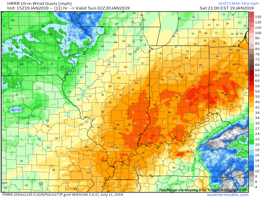 Obviously this will create concerns for power outages, but the other major worry is for developing blizzard-like conditions and whiteouts through the late afternoon into tonight.
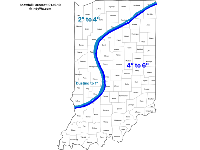
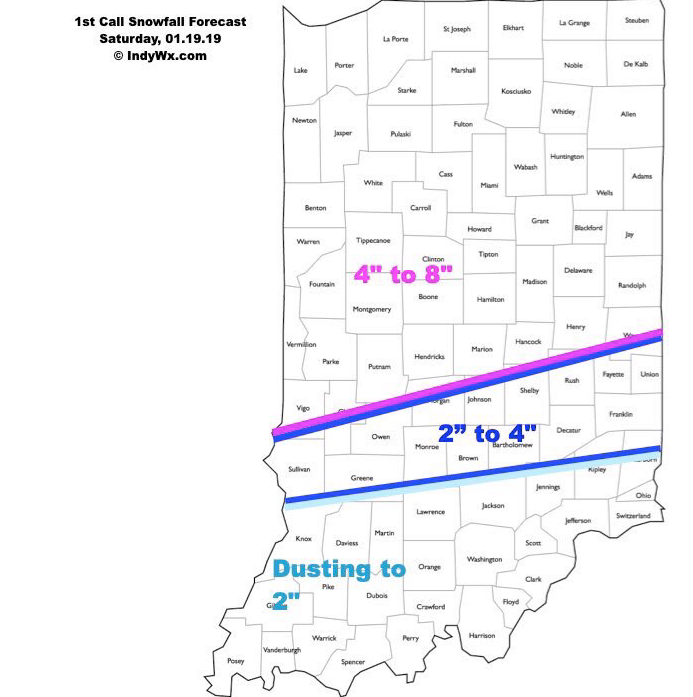
As for snowfall totals, the consensus of latest 12z data continues to support our updated snowfall forecast from this morning.
 We’ll have additional updates later this afternoon here on IndyWx.com and on our social media accounts.
To close, we highly encourage not traveling this afternoon. Conditions are expected to rapidly deteriorate as we move through the next several hours. For many across central and east-central Indiana, roads will likely become impassable by evening with the combination of severe wind gusts and increasing snowfall rates. Major problems from blowing and drifting snow are expected.
More here in a bit! Stay safe!
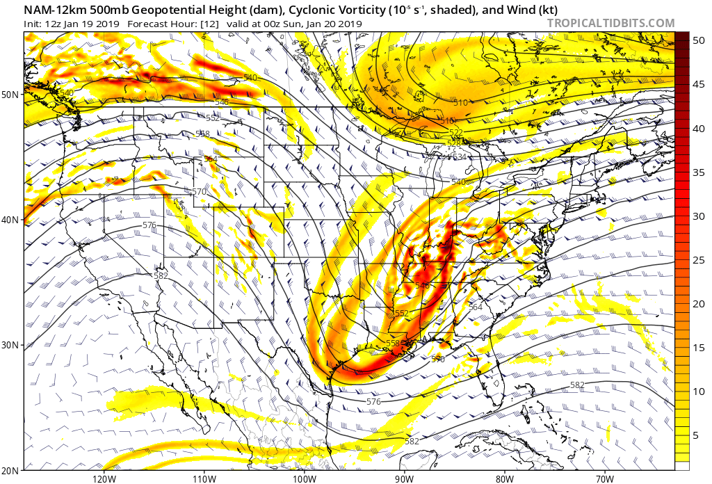
A significant winter storm is on our doorstep and will begin to impact all of the region in the coming hours. Low pressure will continue to deepen as it moves northeast out of Oklahoma, Arkansas, and into Kentucky. As this takes place, copious amounts of moisture will lift north into central Indiana. We think precipitation reaches Indianapolis, itself, during the overnight (likely between 3a and 4a).
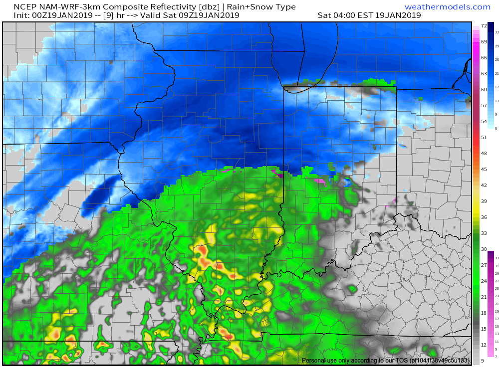 The bulk of the northern half of the state is still expected to receive predominantly snow with this storm. However, things get much more tricky along the I-70 corridor (10 to 20 miles either side) as temperatures will be “marginal” early on in the event (aloft and at the surface) and will lead to quite the headache for the first several hours of this storm. Even as of this update, confidence is low on precipitation type for the I-70 corridor, itself. A difference of half a degree (F) can mean a world of difference with precipitation type (snow, freezing rain, sleet, or rain). Admittedly, concern is growing for the potential of icing in this area before the deeper cold air can arrive and switch things over to snow. On the other hand, should precipitation rates be heavy enough, it’s certainly possible these heavier rates will cool the entire column of air quicker than high resolution modeling currently suggests and a quicker transition to snow would result. “Boom or bust” potential is higher than normal along the immediate I-70 corridor.
Given the above, and the potential of a “deformation band” of snow to develop during the 2nd half of the storm, our forecast snowfall totals remain unchanged.
 Stay tuned and please know we’ll have another update posted Saturday morning.
The other big concern here is the fact that east-northeast winds will turn increasingly strong and gusty as the day gives way to afternoon and evening. Winds may gust as high as 40 to 50 MPH at times during this time period as the storm heads off to the northeast. Even if you accumulate an inch of snow, expect blowing and drifting issues to result. Combine that with rapidly falling temperatures Saturday evening and the stage will be set for slick and hazardous travel throughout the region.
Much more in a few hours around this storm and additional “fun and games” that await next week… (Please send coffee ;-)).
After reviewing overnight and early morning data, our snowfall forecast remains unchanged.
We remain very concerned for the impact of a combination of heavy snow north of the I-70 corridor, strong and gusty winds, and plummeting temperatures.