Updated: 02.08.21 @ 5:35p
You must be logged in to view this content. Click Here to become a member of IndyWX.com for full access. Already a member of IndyWx.com All-Access? Log-in here.

Feb 08
Updated: 02.08.21 @ 5:35p
You must be logged in to view this content. Click Here to become a member of IndyWX.com for full access. Already a member of IndyWx.com All-Access? Log-in here.
Permanent link to this article: https://indywx.com/2021/02/08/video-cold-snowy-pattern-locking-in-for-the-foreseeable-future/
Feb 08
Updated 02.08.21 @ 8:32a
Most of the daytime today will only feature light snow, but don’t let that fool you. With such a cold, arctic airmass in place, even the “light” snow is creating travel issues in spots. Take it slow out there, friends.
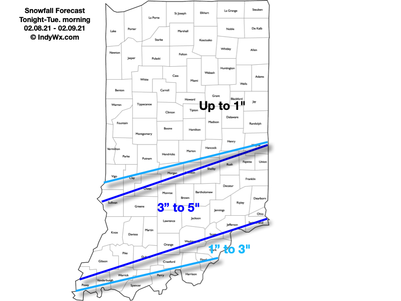
A new piece of upper level energy will streak across the region tonight and help snow to become more organized in aerial coverage. A narrow, but efficient band of steadier snow is expected to get going across south-central Indiana around, or just after, sunset. It’s within this snow where we expect several inches of snow to accumulate tonight and early Tuesday morning.
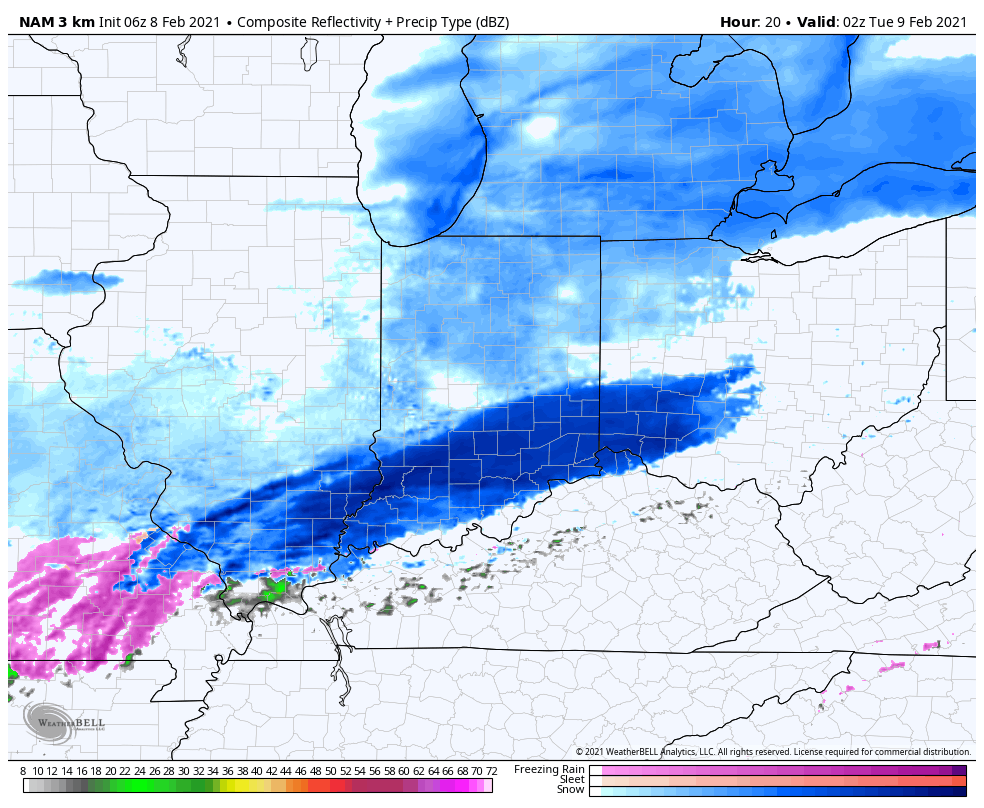
Most of the steady snow will exit to the east before sunrise Tuesday. We’ll then be left with periods of flurries and light snow through the remainder of the day.
Here’s our snowfall forecast with tonight’s system:
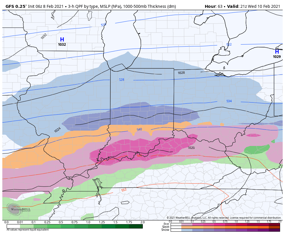
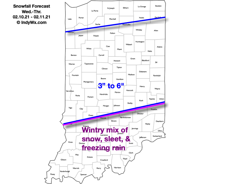
Attention will then shift to a “juicier” midweek storm system. An arctic boundary will remain draped to our south while a surface wave rides northeast along the stalled front. This will allow more widespread, heavier precipitation to push into the region (from southwest to northeast) through the morning Wednesday. For a time, moderate to heavy precipitation rates are expected Wednesday evening into Wednesday night. The early call on this system continues to be for an all snow event across central Indiana (where we think 3″ to 6″ of fresh snow is a good bet) with more of a wintry mix of snow, sleet, and freezing rain across southern portions of the state as warmer air aloft gets pulled north. Unfortunately, I think even southern portions of the state remain cold at the surface, continuing the threat of an icy glaze vs. a plain ole rain.
Here’s our snowfall forecast for Wednesday and Thursday:
As the snow continues to add up, concern will mount around the issues that will likely come from a blowing and drifting perspective- especially as a fresh arctic intrusion arrives late week. If that wasn’t enough, additional “fun and games” are on the table for the upcoming weekend, followed by the coldest air so far this season (and in some cases in a couple of years).
Stay tuned…
Permanent link to this article: https://indywx.com/2021/02/08/multiple-snow-makers-cold-grows-more-bitter/
Feb 07
Updated 02.07.21 @ 9:02p
You must be logged in to view this content. Click Here to become a member of IndyWX.com for full access. Already a member of IndyWx.com All-Access? Log-in here.
Permanent link to this article: https://indywx.com/2021/02/07/video-snowpack-expands-in-the-week-ahead/
Feb 07
Updated 02.07.21 @ 7:48a
It’s a frigid morning across central Indiana. From Indianapolis and points north we’re talking sub-zero cold. Wind chill values are plain out ugly this morning.
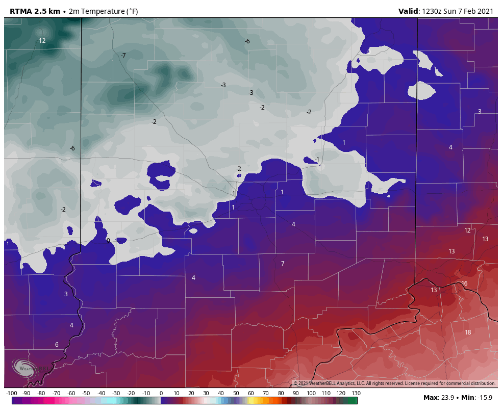
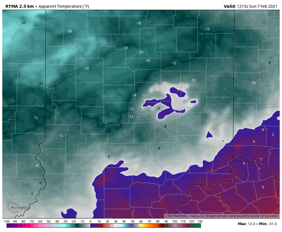
We’re tracking 4 snow makers in the upcoming 7 days and will have a complete breakdown on timing and amounts this evening with our client video update. Winter weather fan? This is a pattern to cherish over the upcoming few weeks. More on the long range will be included as well with this evening’s update.
Make it a great Sunday and we’ll talk with you this evening!
Permanent link to this article: https://indywx.com/2021/02/07/snow-begins-to-pile-up/
Feb 06
Updated 02.06.21 @ 8:51a
You must be logged in to view this content. Click Here to become a member of IndyWX.com for full access. Already a member of IndyWx.com All-Access? Log-in here.
Permanent link to this article: https://indywx.com/2021/02/06/video-unique-stretch-of-prolonged-cold-wintry-conditions/
Feb 05
Updated 02.05.21 @ 4:19p
You must be logged in to view this content. Click Here to become a member of IndyWX.com for full access. Already a member of IndyWx.com All-Access? Log-in here.
Permanent link to this article: https://indywx.com/2021/02/05/video-tracking-multiple-winter-weather-makers-over-the-upcoming-7-10-days/
Feb 05
Updated 02.05.21 @ 7:18a
Where to begin?! Simply put, the pattern over the next 2 weeks is a winter weather lover’s dream setup. Does that mean central Indiana has to “cash in” on every event? Negative. In fact, by next weekend, we believe the Deep South will even get in on the wintry fun (outside of the higher elevations that have been doing quite well this year). That said, systems will be targeting our general area fast and furious and require us to remain on our toes. Given that a more prolonged period of cold is developing, we should be able to build a nice snowpack for outdoor winter enthusiasts over the next 7-14 days.
The setup is all thanks to a persistent negative to deeply negative AO and the associated high latitude blocking. The Pacific pattern is also changing to allow more meaningful cold (truly arctic air is getting involved in the pattern) into the East with staying power. We can thank the now negative EPO for that. That leads us to the PNA. A negative to even neutral PNA will continue to put resistance on the pattern and result in southern ridging at times. That’s especially true early on in this regime. That puts the Ohio Valley in the cross hairs of these systems. As the arctic air takes hold, I still believe eventually we’ll see a more suppressed storm track for a time but that likely doesn’t develop until late next week. Before that, we have multiple storms to track and a snowpack to build. 🙂
First up is an arctic wave that arrives Saturday evening. This is a system that should deposit 1” to 3” of snow, mainly from Indianapolis and points north (dusting up to 1” across the southern half of the state). This will be a fast moving system that will arrive around 5p across western parts of the state and will be out of here during the predawn hours Sunday.

Temperatures will crash Sunday morning into the single digits and highs will likely only climb into the middle teens. Good thing there’s a Super Bowl to focus on.
Additional upper level energy will result in light snow moving back in here Monday afternoon and night. With cold, arctic air in place, this system should be able to squeeze out an additional dusting to inch of snow (even as weak as it is).
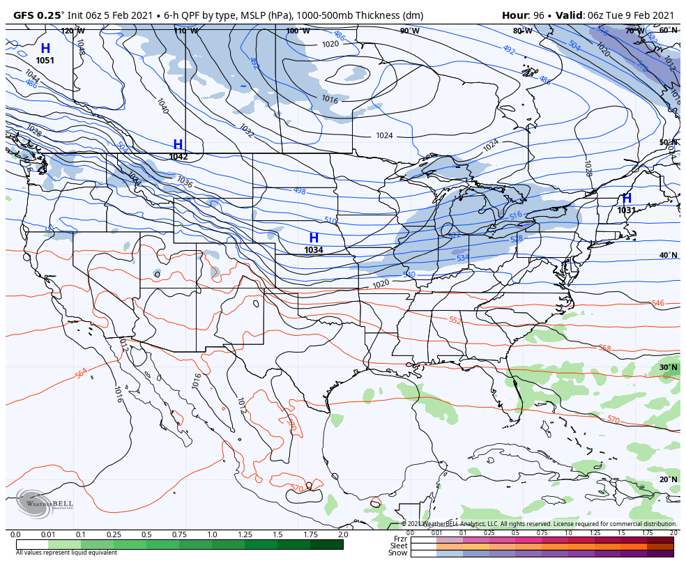
That leads us to Tuesday night and Wednesday. A surface wave is expected to develop in the Ark-la-tex region and lift northeast. This will be a “juicier” event and result in widespread wintry precipitation across the state. Early thinking here is that across central and northern parts of the state, this will be mainly a snow event. Southern portions of the state may mix with sleet and/ or freezing rain. While we can’t throw out numbers this early, where it stays all snow, several inches seem likely.

If that’s not enough, more “fun and games” are dialed up with yet another system next Thursday and Friday. This, too, could be a meaningful winter event, locally, and will require close attention moving forward.
From a temperature perspective, it continues to look like a case of “delayed but not denied” on the topic of truly dangerous arctic air. As the pattern evolves and a snowpack is established, the concern here is that we’re looking at a period of severe cold (double digit below zero temperatures and wind chill values exceeding 20° below zero) by late next week/ next weekend.
More later today! Have a great Friday, friends!
Permanent link to this article: https://indywx.com/2021/02/05/buckle-in/
Feb 04
Updated 02.04.21 @ 7:15a
You must be logged in to view this content. Click Here to become a member of IndyWX.com for full access. Already a member of IndyWx.com All-Access? Log-in here.
Permanent link to this article: https://indywx.com/2021/02/04/video-tracking-multiple-winter-weather-makers-into-next-week/
Feb 03
Updated 02.03.21 @ 7:24p
You must be logged in to view this content. Click Here to become a member of IndyWX.com for full access. Already a member of IndyWx.com All-Access? Log-in here.
Permanent link to this article: https://indywx.com/2021/02/03/video-a-busy-winter-pattern-settles-in/
Feb 03
Updated 02.03.21 @ 8:19a

Best Day Of The Week…We can’t get too picky this time of year in the weather department. Long time fellow Hoosiers know to never take a day featuring sunshine for granted in early February. Though still chilly, given the pattern ahead, I’d recommend getting outside and enjoying some of those rays today.
A cold front blows into town Thursday and will deliver a chilly rain by the afternoon. As colder air rushes in on the backside of the system, rain will likely mix with and end as a period of snow across the northern half of the state Thursday evening. Though the moisture will be leaving as the cold air is arriving, we may still be able to squeeze out a dusting to 1″ of wet snow for northern areas.
Attention will then shift to an arctic wave that will move into the Ohio Valley this weekend. Snow will become widespread across the central Plains Friday evening into Saturday morning before expanding east into our neck of the woods Saturday afternoon into Sunday morning. With cold air in place, this will be a higher ratio snow event than we’ve seen so far this winter (“fluff factor” will be in full effect). Additionally, strong and gusty winds are expected during this time frame leading to blowing and drifting concerns. Stay tuned. We’ll take a stab at early accumulation numbers with this evening’s Client Video update.
Additional upper level energy will scoot through the region into early next week, keeping a supply of snow showers ongoing. While still cold, models have pushed back the truly dangerous cold until late week. Case of delayed, but not denied? Unfortunately think so…
Permanent link to this article: https://indywx.com/2021/02/03/02-03-21-weather-bulletin-keeping-a-watchful-eye-on-the-weekend/