Things are growing a bit dry around these parts. Officially we’re down 3.25″ for the month and close to 5″ on the year. (Climate information for IND: http://w2.weather.gov/climate/index.php?wfo=ind)
Rains the past (14) days have favored the central region, falling apart as the systems push east and northeast. Texas and Oklahoma continue to make news headlines from severe flooding. – Too much of a good thing all at once.
 Officially we’re not even listed in the “abnormally dry” shading, but that very well may change with the Thursday update. Courtesy of the Regional Drought Monitor:
 Anytime you go through May with a significant rainfall deficit it raises a concern for continued dry times going through summer. Dry typically breeds dry this time of year, and eventually heat. That said, a strengthening El Nino will fight the recent trend. Around these parts weak to moderate summer El Ninos tend to yield average (to slightly above) precipitation and average (to slightly below normal) temperatures. Recent trends, combined with longer term forecasts certainly prove to lead to a battle in the coming weeks and months…
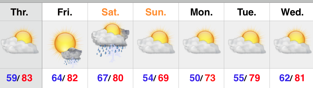
Shorter term as we progress through the coming days, here’s how we currently assess rainfall coverage:
- Wednesday: Scattered- favoring eastern and southern portions of the state
- Thursday: Mostly dry
- Friday: Widely scattered
- Saturday: Scattered to widespread showers and thunderstorms, but many dry hours, as well.
- Sunday: Scattered coverage
* Rainfall potential through the weekend: 0.50″-1″ for most, with locally heavier totals under stronger storms.