Sunny Sunday!

Screen Shot 2015-06-28 at 8.28.41 AMHighlights:

  • Cool and refreshing start
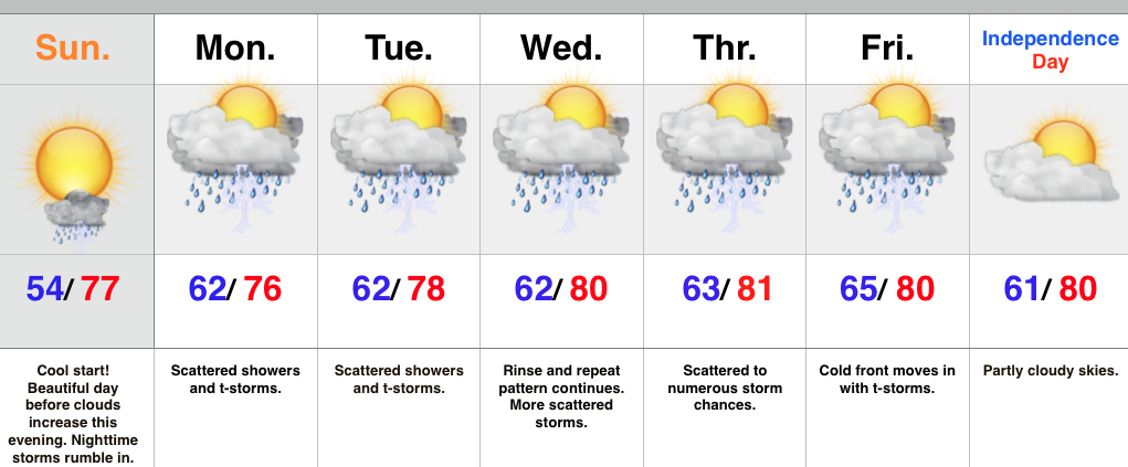
  • Sunny Sunday before clouds increase late
  • Storms rumble in tonight
  • Unsettled week

Sunday has dawned bright and sunny, along with an unseasonably cool feel (I’ll take this every day this time of the year)!  Most of today will feature lots of sunshine, but clouds will be on the increase this evening and thunderstorms will rumble into central and northern IN later tonight.

Unsettled weather will be the rule this week, including multiple disturbances tracking across the region.  These individual disturbances will enhance coverage of showers and thunderstorms from time to time this week.  While no all day rains are anticipated, the additional rain and storms certainly isn’t good news for the region.

We continue to keep a close eye on the all-important 4th of July forecast.  As of now, it appears as if we’ll see a cold front pass Friday night and provide drier weather for Saturday, but stay tuned.

Upcoming 7-Day Rainfall forecast: 1.5″-2″

Breezy And Much Cooler Today; Beautiful Sunday On Tap…

Flooding is an issue across many central IN communities this morning. Particularly hard hit is the Muncie community.  Zionsville’s Eagle Creek is also above flood stage this morning.    Thankfully, breezy…

You must be logged in to view this content. Click Here to become a member of IndyWX.com for full access.  Already a member of IndyWx.com All-Access?  Log-in here.

Heavy Rain And Storms To Close The Work Week…

An area of low pressure will track across the Ohio Valley Friday and help rain overspread the region from west to east as the day progresses. Embedded thunderstorms can also…

You must be logged in to view this content. Click Here to become a member of IndyWX.com for full access.  Already a member of IndyWx.com All-Access?  Log-in here.

More Heavy Rain To Go Before Weekend Clearing…

Screen Shot 2015-06-25 at 7.53.15 AMHighlights:

  • Couple round of storms today
  • Heavy rain; flood threat Friday afternoon into early Saturday
  • Much cooler and drier this weekend

The morning is off to a wet start, including some embedded thunder and while we anticipate a break in the rain from late morning into the afternoon, additional thunderstorm development is possible by evening.  A slight risk of severe storms is in place across the southern half of the state.

Low pressure will move this way Friday and strengthen as it tracks into the eastern Lakes region.  This will spell very wet times around these parts from the second half of Friday into the wee morning hours Saturday.  Much cooler air and windy conditions will push into central IN Saturday on the backside of the low pressure system.  Before we enjoy those cooler conditions, heavy downpours are likely Friday afternoon into Friday night, including the potential of localized flooding.  If you live near a creek or stream, be sure to have your flood plan in place should rapid water rise occur.

As mentioned above, we’ll dry out rather rapidly Saturday afternoon and this will be followed by a beautiful Sunday.  How many times can we say late June starts in the lower to middle 50s, no humidity, lots of sunshine, and highs in the upper 70s?! 🙂

We’re back to scattered shower and thunderstorm chances early next week, with continued cooler than average temperatures.

Upcoming 7-Day Rainfall Forecast: 2″-3″ (locally heavier totals)

Nice Weather Moves In For A Couple Days; Severe Storms Late Wednesday-Thursday…

Screen Shot 2015-06-23 at 7.41.11 AMHighlights:

  • Turning less humid with increasing sunshine this afternoon
  • Next round of strong to severe storms arrive late Wednesday night-Thursday
  • Cooler, drier weekend ahead

A frontal boundary will slip through the region today and provide an increasingly sunny sky this afternoon along with less humid conditions.  A disturbance may provide a shower or storm across far southwestern IN Wednesday, but we think the day will remain dry for the majority of the region.  The next round of strong to severe thunderstorms for our particular part of the region will come late Wednesday night into Thursday morning.  Similar to past thunderstorm complexes, damaging wind and localized flash flooding will be greatest concerns.  Scattered storms continue Friday, but the cold front should sweep the state Friday night and help provide a very nice weekend, including cooler and drier air.

Upcoming 7-Day Rainfall Forecast: 1″ – 1.5″