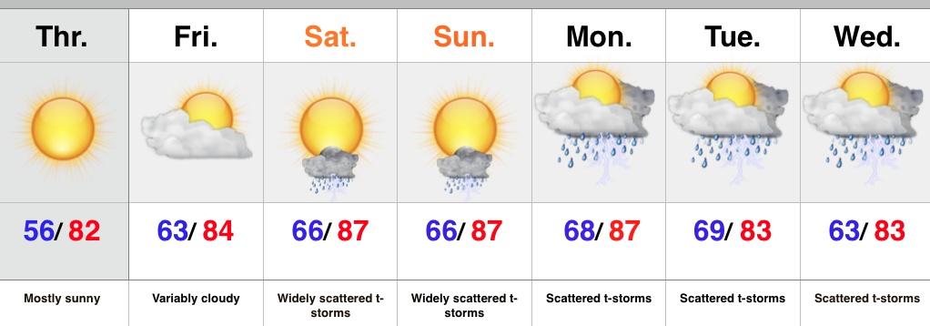
Category: T-storms

Stormy Times Later Tonight/ Early Thursday; Much Colder To Close The Week…

Screen Shot 2015-03-25 at 10.39.34 AMBusy Times Continue…After an initial round of rain and embedded thunder moved through the region overnight and early this morning, most of today will be very quiet.  Look for a gusty southwest wind and increasing sunshine as we head into the afternoon hours.

Rain and storm chances will ramp up as we head into the nighttime hours and overnight.  A period of heavy rain and noisy thunderstorms will rumble through central Indiana after midnight into the pre dawn hours Thursday.  Additional rainfall of 1″ is a good bet tonight/ early Thursday.

MUCH colder air will quickly sweep into the region Thursday and could even allow some of the back end rain to switch to some wet snow before ending across north and northeastern portions of the area.  This won’t accumulate.

We’ll wrap the week up on a cold and wintry note.  Scattered snow showers and well below normal temperatures can be expected Friday, with dry and cold conditions Saturday.

The next weather maker will blow through Sunday in the form of a warm front.  This will spark a few showers Sunday afternoon and evening along with providing a warmer time of things early next week.

Upcoming 7-Day Precipitation Forecast:

  • 7-Day Rainfall Forecast: 1.00″ – 1.25″
  • 7-Day Snowfall Forecast: Trace

Permanent link to this article: https://indywx.com/stormy-times-later-tonight-early-thursday-much-colder-to-close-the-week/

Active Times…

An active weather pattern will put the Ohio Valley in for busy times this week. First up is a snow maker that will drop in this afternoon. Snow may even…

You must be logged in to view this content. Click Here to become a member of IndyWX.com for full access.  Already a member of IndyWx.com All-Access?  Log-in here.

Permanent link to this article: https://indywx.com/active-times/

Sunday Afternoon Catch Up…

It has been a very busy weekend and I apologize for a lack of posts today until now. We have a very active weather pattern on our hands this week.…

You must be logged in to view this content. Click Here to become a member of IndyWX.com for full access.  Already a member of IndyWx.com All-Access?  Log-in here.

Permanent link to this article: https://indywx.com/sunday-afternoon-catch-up/

Busy Weather Week Next Week…

After a relatively quiet week of weather around these parts, next week promises to be different.  We’ll deal with showers and thunderstorms Wednesday into Thursday. Heavy rain will be possible…

You must be logged in to view this content. Click Here to become a member of IndyWX.com for full access.  Already a member of IndyWx.com All-Access?  Log-in here.

Permanent link to this article: https://indywx.com/busy-weather-week-next-week/

Not A Bad Weekend Coming…

Screen Shot 2015-03-19 at 7.57.20 PMIncreasing Sunshine…Early clouds and left over light rain will give way to afternoon sunshine Friday.  All in all, a nice weekend is on the way!  We can expect a sunny, mild, and breezy Saturday, but colder conditions await for the second half of the weekend.  A dry cold front will sweep the state Saturday night and usher in a chilly Sunday.

A weak weather maker will scoot across the region Monday with a light rain or light snow shower and reinforcing chilly air.

Looking ahead, a cold front will take aim on the region Wednesday and we may be able to introduce just enough instability to promote an embedded thunderstorm as the boundary sweeps through the state.  Cooler, showery weather can be expected Thursday.

Upcoming 7-Day Precipitation Forecast:

  • 7-Day Rainfall Forecast: 0.50″ – 1.00″
  • 7-Day Snowfall Forecast: Trace

Permanent link to this article: https://indywx.com/not-a-bad-weekend-coming/