Cool, Crisp Start; Dry Weather Continues…

Screen Shot 2015-09-13 at 8.34.01 AMHighlights:

  • Chilly start
  • Sunshine galore
  • Moderating temperatures

October-like weather will remain in place today, complete with wall-to-wall sunshine.  We suggest finding a way to get outside to watch the Colts kick off the season!  Dry conditions will remain with us for the balance of the work week before we introduce shower and thunderstorm chances into the forecast heading into next weekend.  Timing differences are there in regards to the arrival of our next cold front, but for now we’ll mention scattered showers and thunderstorms Friday and Saturday.

7-Day Rainfall Forecast: 0.25″ – 0.50″
Wednesday Weather Notebook…

Gloomy Day:      A cold front will slowly push through the region today. Look for a mostly cloudy Wednesday with rain, especially through the morning hours. Rain will come to…

You must be logged in to view this content. Click Here to become a member of IndyWX.com for full access.  Already a member of IndyWx.com All-Access?  Log-in here.

Summer Like Now, But Fall Weather Is Coming…

Screen Shot 2015-09-07 at 9.57.37 PMHighlights:

  • Shower and storm chances
  • One-two punch of cooler air
  • Very fall-like weekend

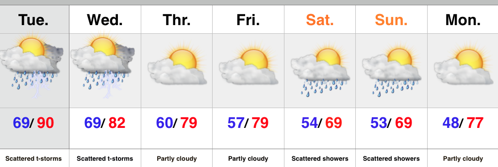
A cold front is draped across the Plains this evening helping to ignite thunderstorms.  This front will slowly continue to push east and be responsible for increased chances of showers and thunderstorms across our neck of the woods late Tuesday into Wednesday.  We think a rather large area of showers and thunderstorms will diminish in intensity and coverage as it pushes across the state Tuesday night.  For an area that’s grown dry as of late, that’s not the news we want to hear.  There will be another opportunity for showers and thunderstorms to develop ahead of the frontal boundary that passes late Wednesday.

Drier and cooler weather will build in to close the work week, but a secondary push of cool, autumn-like air will arrive in time for the weekend.  Add in some upper level energy and we’ll need to mention a passing shower Saturday and Sunday.  It’ll feel drastically different this weekend that what we experienced last weekend.  Pumpkin spice latte, anyone? 🙂

Upcoming 7-Day Rainfall Forecast:  0.25″ – 0.50″

Labor Day Weather Notebook…

September Scorcher: September has gotten off on a downright hot note.     While we have a couple more days of highs that will push 90°, changes are brewing that will…

You must be logged in to view this content. Click Here to become a member of IndyWX.com for full access.  Already a member of IndyWx.com All-Access?  Log-in here.

Thunderstorms, Especially West…

Screen Shot 2015-09-05 at 9.51.02 AMHighlights:

  • Western storms
  • Hot Labor Day
  • MUCH cooler late next week

Thunderstorms will slowly push south this morning, especially across western portions of the state.  Many will be asking “what storms?” while others are getting pounded by heavy rain, vivid lightning, small hail, and strong winds.  Best chances of getting a storm will be along and west of I-65.

Drier conditions will build in for the second half of the weekend and into early next week.  Labor Day will be a very hot and humid one.

Rain and storm chances will increase as we push into the mid week stretch as a strong cold front moves into the Mid West.  MUCH cooler air will infiltrate the state late next week and things will be feeling very “fallish” by the weekend.

Upcoming 7-Day Rainfall Forecast: 0.50″-1″ (locally heavier totals)