VIDEO: Stormy By Evening; Much Colder This Weekend…
You must be logged in to view this content. Click Here to become a member of IndyWX.com for full access. Already a member of IndyWx.com All-Access? Log-in here.
You must be logged in to view this content. Click Here to become a member of IndyWX.com for full access. Already a member of IndyWx.com All-Access? Log-in here.
 Highlights:
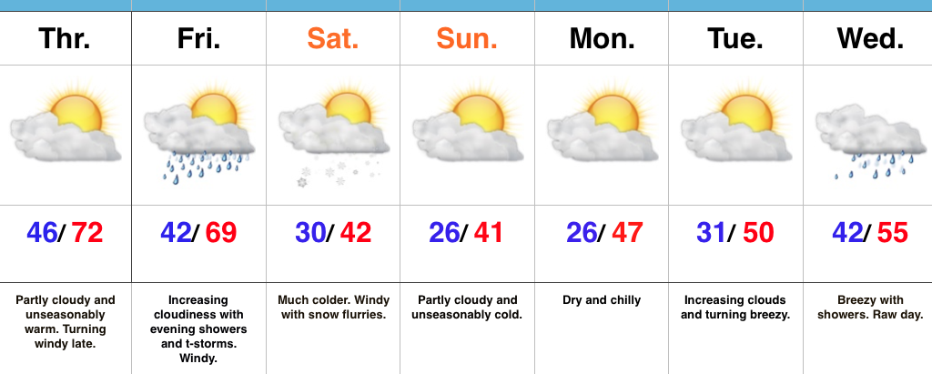
Changeable Weather…If you don’t find a way to get outside today something is wrong. Let the boss know IndyWx.com gave you permission to spend an extended lunch outdoors today. 🙂 Sunny skies and unseasonably warm temperatures will be with us through the day, along with an increasingly gusty afternoon wind.
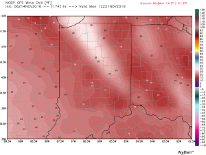
Clouds increase Friday and showers develop Friday evening. A couple of stronger thunderstorms are also possible as the front sweeps through the state. While we’re not forecasting a widespread severe wind potential, one or two strong and gusty storms are possible. The front will hit like a wall Friday night and feature an abrupt wind shift and plummeting temperatures. That high Saturday in the lower 40s will be predawn as most of the day will be spent in the 30s with gusty winds and snow flurries. Steadier snow squalls will be found across north and northeast IN.
Dry, chilly weather will be with us for the remainder of the weekend, continuing into the beginning of the Thanksgiving week ahead. Our next storm system is slated for the big travel day Wednesday. Expect showers and gusty winds followed by colder weather for Thanksgiving, itself.
Upcoming 7-Day Precipitation Forecast:
You must be logged in to view this content. Click Here to become a member of IndyWX.com for full access. Already a member of IndyWx.com All-Access? Log-in here.
 Highlights:
Brace For Changes…The short-term remains very quiet and pleasant. If you haven’t already, we suggest knocking out that remaining yard work for the season, or get a jump on the outdoor Christmas lights! (Rude changes loom).
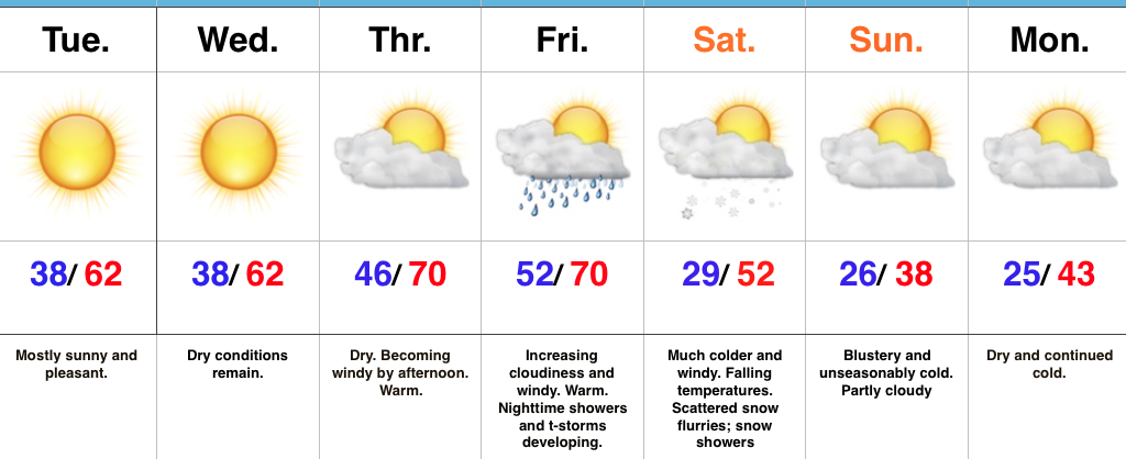
Winds will turn gusty out of the southwest Thursday, especially by afternoon. These strong and gusty SW winds will top 40 MPH Thursday into Friday, but also serve to help give temperatures a boost. Highs both Thursday and Friday will be near record levels.
We should remain dry through the daytime Friday, but a band of showers and embedded thunder will rumble through the state Friday night as a strong cold front passes through. Behind the cold front, expect an abrupt wind shift to the northwest and falling temperatures through the day Saturday. Heavier jackets and coats will be required as wind chills in the 20s fall into the teens Saturday night into Sunday morning. Left-over, “backlash” moisture will fall in the form of flurries and scattered light snow showers. Further north, light accumulations of snow are possible across northern IN snowbelt communities.
Cold, dry weather will continue into early next week. Looking further ahead, another storm system looms around Thanksgiving.
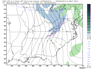
Upcoming 7-Day Precipitation Forecast:
A rather pleasant, benign week of weather will transition to a rude feel by the weekend.
A cold front will sweep through the state Saturday morning and will help the season’s first blast of true, winter-like air plunge southward over the weekend, into early next week. Ahead of the cold front, a band of showers and perhaps a clap of thunder will track east. As of now, rainfall totals don’t look particularly impressive (0.10″-0.25″).
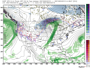
Ahead of the front, winds will gust out of the southwest Thursday afternoon and Friday (in the 30-40 MPH range), but will shift around to the northwest Saturday (same 30-40 MPH potential) and drive a much colder air mass southeast. Temperatures will fall through the day Saturday and temperatures will grow cold enough Saturday evening into Sunday to allow “backlash” moisture to fall as scattered snow showers and snow flurries. Further north, in the snowbelt regions, heavier lake-generated snow bands and squalls will develop over the second half of the weekend.
Wind chills will fall into the teens Sunday night into Monday morning.
Longer term, data continues to suggest we continue to transition, overall, towards a colder and stormy pattern in the targeted Thanksgiving to Christmas period. More on that later this week…