
You must be logged in to view this content. Click Here to become a member of IndyWX.com for full access. Already a member of IndyWx.com All-Access? Log-in here.
Category: T-storms
Permanent link to this article: https://indywx.com/video-sunday-morning-showers-give-way-to-afternoon-sunshine/
May 20
Scattered Storm Chances Through Sunday Morning; Much Cooler Next Week…
 Highlights:
- Scattered storm chances continue
- Much cooler next week
- Midweek showers return
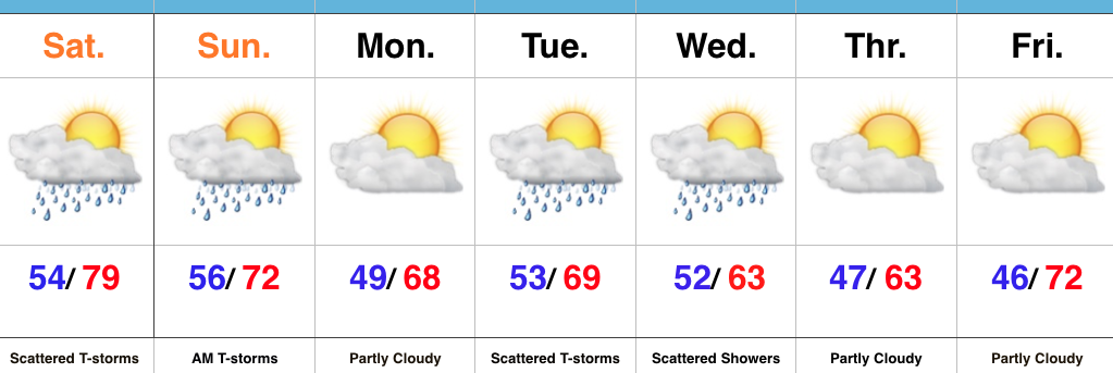
Watching For Afternoon And Evening Storms…We’re starting the day with low clouds, fog, and a chilly easterly breeze. That said, a warm front will begin to lift north this afternoon, allowing a warmer and increasingly muggy feel to return. Scattered thunderstorms will also increase in overall coverage later this afternoon and evening. While widespread heavy rains aren’t anticipated, localized heavy downpours are possible in slower moving, stronger storms.
Scattered showers and thunderstorms will remain Sunday morning, but a cold front will pass around lunchtime with drier air arriving by the afternoon hours. If you have plans outdoors Sunday, the afternoon and evening looks absolutely beautiful with a more pleasant air mass building in with those drier conditions.
Unsettled conditions return Tuesday into Wednesday with unseasonably cool air. As of now, the early outlook for the big race weekend and Memorial Day holiday is a dry one, with just a scattered shower chance Saturday. Stay tuned.
Upcoming 7-Day Precipitation Forecast:
- Snowfall: 0.00″
- Rainfall: 0.50″ – 1.00″ (Locally heavier amounts)
Permanent link to this article: https://indywx.com/scattered-storm-chances-through-sunday-morning-much-cooler-next-week/
May 19
Periods Of Storms Through The Weekend…
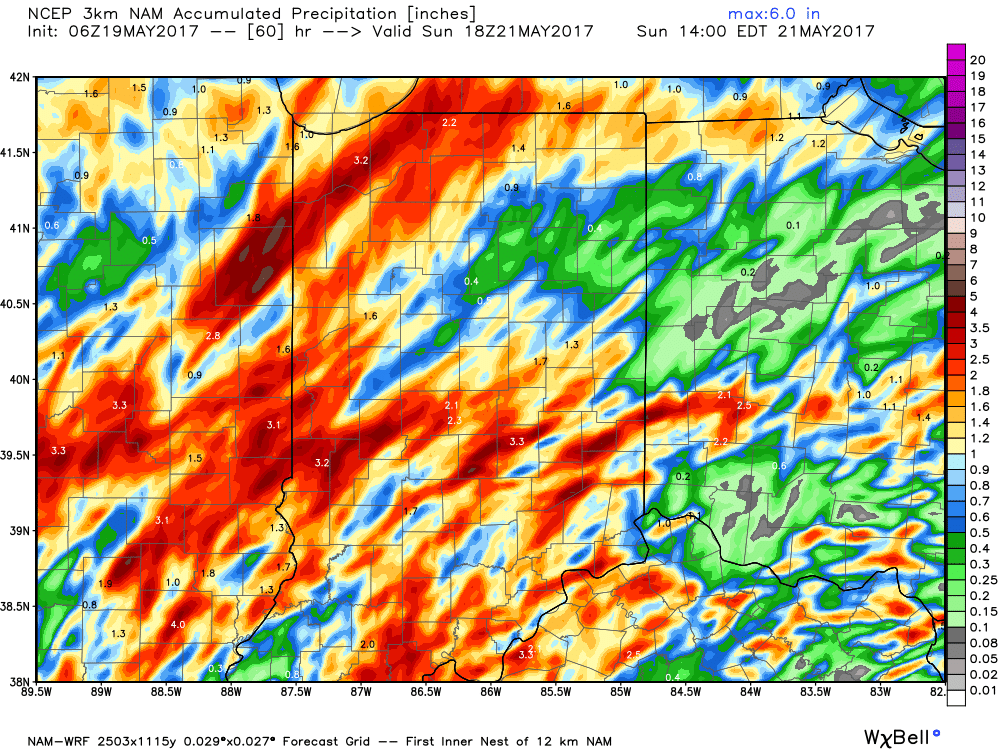
The Storm Prediction Center includes portions of the state, including Indianapolis, under a Slight Risk of severe weather today and Saturday.
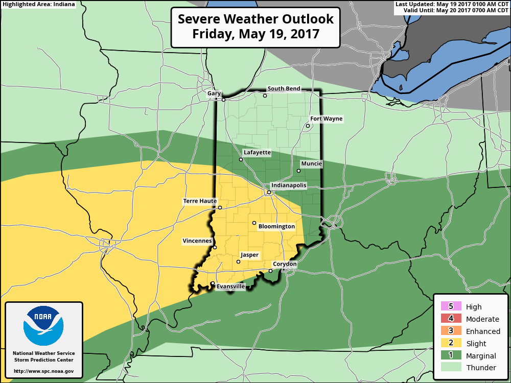
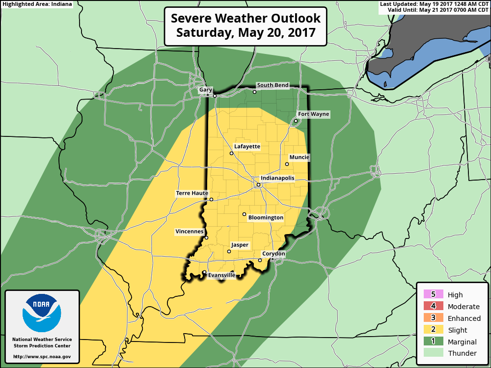 The culprit is a stalled frontal boundary that lies across the center of the state. This front will “bobble” around from time to time over the next 24 hours before lifting back north as a warm front Saturday evening. Accordingly, expect a significant temperature spread from north to south today and periods of showers and thunderstorms scattered about central Indiana. With high precipitable water values, localized heavy rains are expected, but, as mentioned, this won’t be a “uniform” event and there will be “haves and have nots.” Some neighborhoods can expect to pick up a 2-3 inches of rain between now and Sunday afternoon. Greatest severe threats include large hail and damaging straight line winds with storms, but we’ll also have to monitor things for the potential of a couple rotating storms as well.
Permanent link to this article: https://indywx.com/periods-of-storms-through-the-weekend/
May 16
VIDEO: Late Week Storms And Much Cooler Next Week…
You must be logged in to view this content. Click Here to become a member of IndyWX.com for full access. Already a member of IndyWx.com All-Access? Log-in here.
Permanent link to this article: https://indywx.com/video-late-week-storms-and-much-cooler-next-week/
May 16
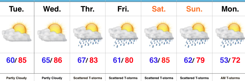
Humidity Increases; Late Week Storms Then Cooler…
 Highlights:
- Sunshine and warmth continues
- Increasingly muggy feel develops
- Storm chances return
- Much cooler next week
Very Warm And Increasingly Humid…High pressure will supply continued dry conditions, along with unseasonably warm temperatures through midweek. A southwesterly air flow will help push an increasingly muggy feel into the region by Wednesday. “Air you can wear” will be an appropriate way to sum things up! 🙂
That increasing moisture will eventually yield better coverage of showers and thunderstorms as we move through late week into the weekend. It certainly won’t rain the entire time, but periods of scattered thunderstorms will be with us Thursday through Monday morning. With high moisture content, locally heavy rains will be possible.
A cold front will move through the state Sunday night and Monday and result in a significantly cooler trend next week.
Upcoming 7-Day Precipitation Forecast:
- Snowfall: 0.00″
- Rainfall: 1.50″ – 2.00″
Permanent link to this article: https://indywx.com/humidity-increases-late-week-storms-then-cooler/