Updated 07.07.22 @ 8:42a
You must be logged in to view this content. Click Here to become a member of IndyWX.com for full access. Already a member of IndyWx.com All-Access? Log-in here.

Jul 07
Updated 07.07.22 @ 8:42a
You must be logged in to view this content. Click Here to become a member of IndyWX.com for full access. Already a member of IndyWx.com All-Access? Log-in here.
Permanent link to this article: https://indywx.com/video-fingers-crossed-for-more-widespread-rain-tomorrow-longer-range-pattern-takes-on-a-drier-warmer-than-average-look/
Jul 06
Updated 07.06.22 @ 5:05p
You must be logged in to view this content. Click Here to become a member of IndyWX.com for full access. Already a member of IndyWx.com All-Access? Log-in here.
Permanent link to this article: https://indywx.com/video-looking-at-the-2nd-half-of-the-week-and-into-week-2/
Jul 05
Updated 07.05.22 @ 7:58a
A very busy mid-summer pattern will take up residence through the remainder of the week. Multiple storm clusters will ride southeast into the region, some of which will feature severe wind gusts. The Storm Prediction Center includes a threat of severe weather for Indiana today through Thursday (this will likely get extended into the Friday/ Saturday time period before drier, more stable air can work in here).
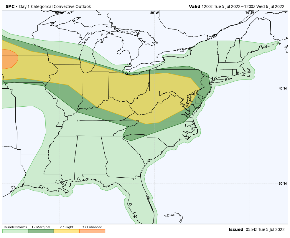


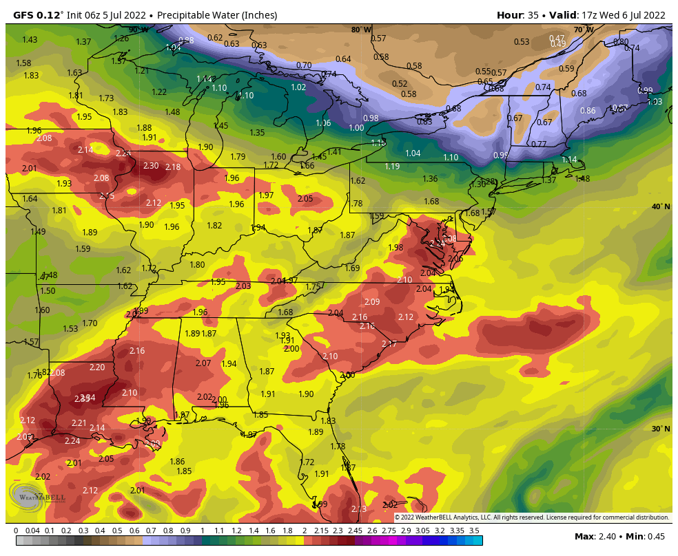
Localized flash flooding will also become a concern, especially towards mid and late week as these storm clusters track over the same areas. Juicy precipitable water values (2”+) will help feed these storm clusters, turning them into prolific rain makers at times. It should be noted that some central IN communities have missed out on recent rains, so rainfall rates of 2”+ / hour falling on rock hard soils will have no problem running off and leading to flash flooding at times.
Drier air will eventually build in here by the weekend and this will lead to a temporary pull back in rain/ storm coverage, and a much more pleasant airmass. Timing, yet again, is on our side.
Tomorrow is a travel day so please expect a later than normal client video post. Should have things online by mid evening, or so, Wednesday.
Permanent link to this article: https://indywx.com/and-then-came-the-rain-and-storms/
Jul 04
Updated 07.04.22 @ 8a 1.) Happy Independence Day! We should squeeze in one more dry day. It’ll be hot with highs surging into the lower 90s. We’ll also notice an…
You must be logged in to view this content. Click Here to become a member of IndyWX.com for full access. Already a member of IndyWx.com All-Access? Log-in here.
Permanent link to this article: https://indywx.com/happy-independence-day-opportunity-for-multiple-strong-storm-clusters-this-week/
Jul 03
Updated 07.03.22 @ 6:40a

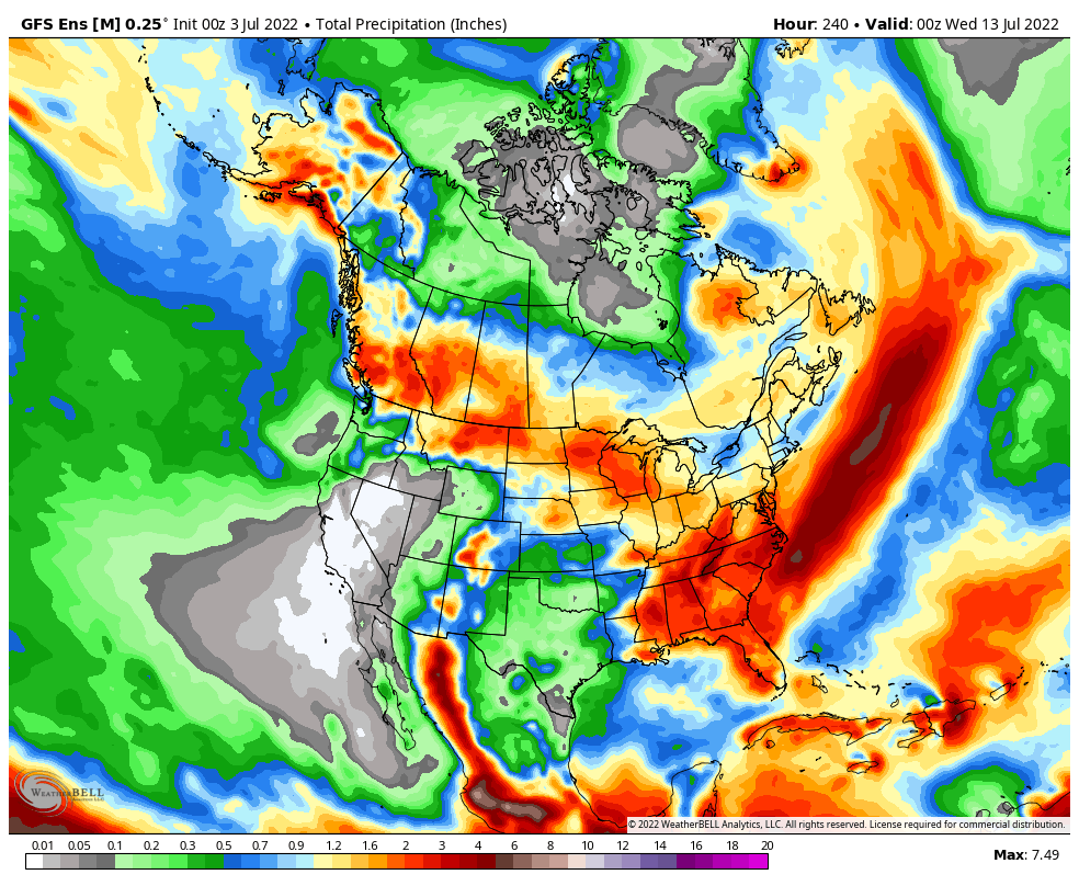
Forecast Period: 07.03.22 through 07.13.22
After a quiet holiday weekend, a much more active pattern will take hold as we navigate the 1st half of July. It won’t rain everyday, but chances of benefitting from soaking rain in more widespread fashion will be on the rise as we move into the middle and latter part of this week into the following week.
Serious heat will bake the Plains while a cooler pattern dominates the Northeast region. In between, here on the home front, we’ll note heat trying to expand northeast into the Ohio Valley (and there will be several 90°+ days thrown in the 10-day period), but each time it may look like the heat is here to stay for more than a few days, we’ll likely get cooling relief from cold fronts moving southeast around the periphery of the ridge.
We’ll have to pay close attention to some of the more “mature” storm complexes including a heightened threat of damaging straight line winds give the overall pattern. It’s impossible to pin down which complexes may include a better threat of severe weather from this distance, but this threat may include a closer look as we move into the middle and latter part of the week.
10-Day Rainfall Forecast: 1”-2”
Permanent link to this article: https://indywx.com/weekly-agwx-and-severe-weather-outlook-44/