Category: Summer
-
Filed under AG Report, Autumn, Forecast Discussion, Forecast Models, Harvest'18, Rain, Summer, T-storms, Unseasonably Cool Weather, Unseasonably Warm, Weather Rambles, Windy
-
October 3, 2018
I.) An unseasonably warm pattern will remain as we move into the middle of the week. A more summer-like feel can be expected as opposed to the increasingly chilly early October air we should be dealing with. Highs will reach the middle 80s this afternoon along with a gusty SW breeze.
 II.) After a windy and warm Wednesday, scattered showers and thunderstorms will return Thursday. Not everyone will get wet, but a few locally heavy downpours can be expected.
 III.) The ridge will “flex its muscle” into early and middle parts of next week and promote an extended (and unusual) stretch of 80s. Don’t put those shorts away just yet…
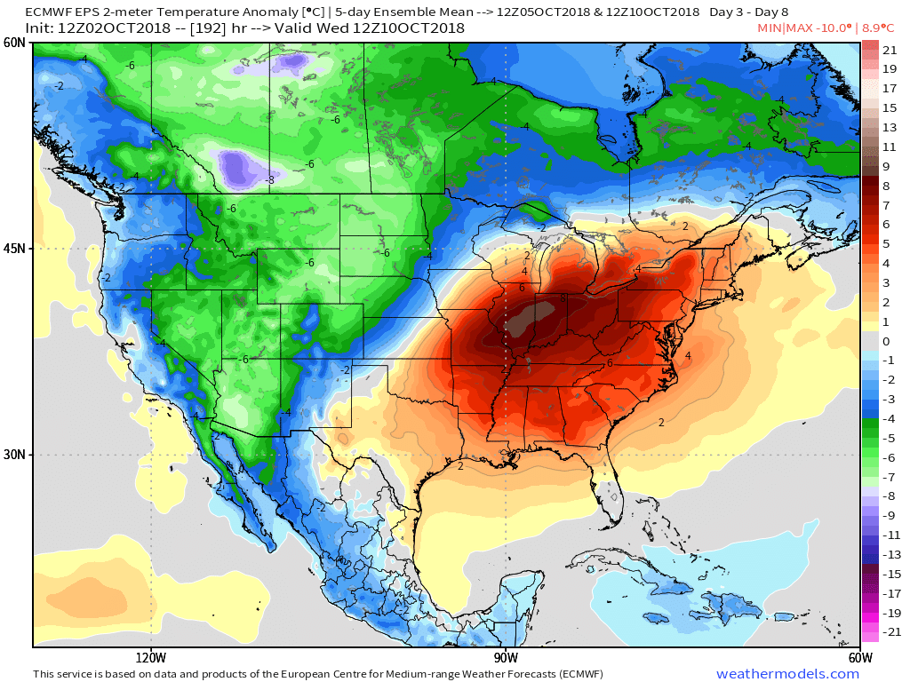 IV.) A “game changer” of a cold front will approach late next week with better chances of organized rain and storms followed by a return of more seasonal times…
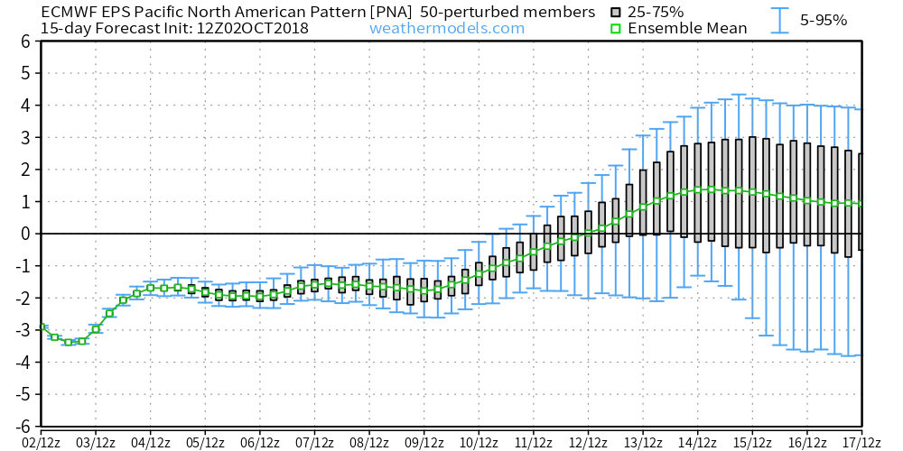
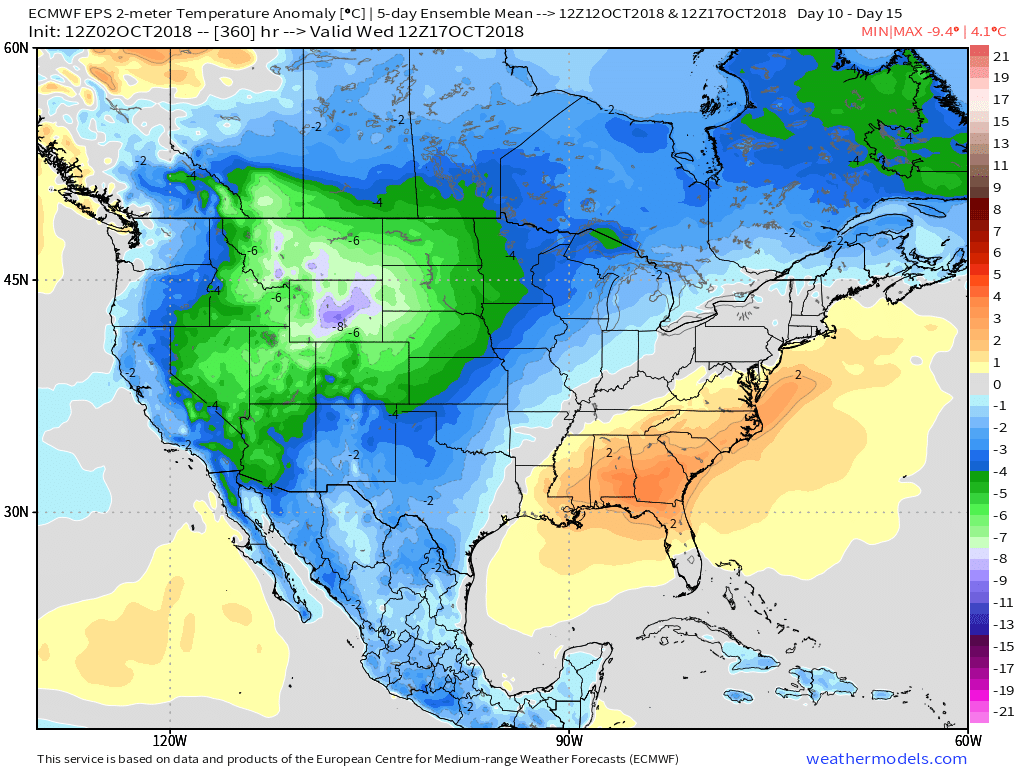
 V.) Ingredients are in place for a significant shift in the pattern around the middle of October and colder times continue to look like they will return as we flip the page into Weeks 2-3.
Permanent link to this article: https://indywx.com/2018/10/03/wednesday-morning-rambles-9/
-
Filed under Autumn, Forecast Discussion, Forecast Models, Harvest'18, Rain, Summer, T-storms, Unseasonably Cool Weather, Unseasonably Warm, Weather Videos
-
October 1, 2018
You must be logged in to view this content. Click Here to become a member of IndyWX.com for full access. Already a member of IndyWx.com All-Access? Log-in here.
Permanent link to this article: https://indywx.com/2018/10/01/video-jailbreak-pattern/
The past couple of days have provided a classic fall feel across the region, but changes loom.
The PNA (Pacific North America Pattern) is forecast negative- at times, strongly so- through the better part of the first half of October.
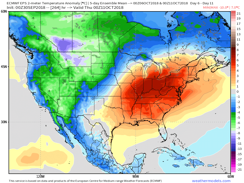
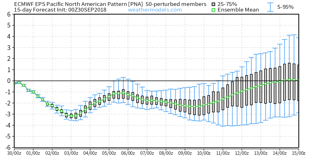 Accordingly, we would expect to see a deep trough across the west and ridging/ associated warmer pattern across the east. Sure enough, that’s what the modeling is painting.
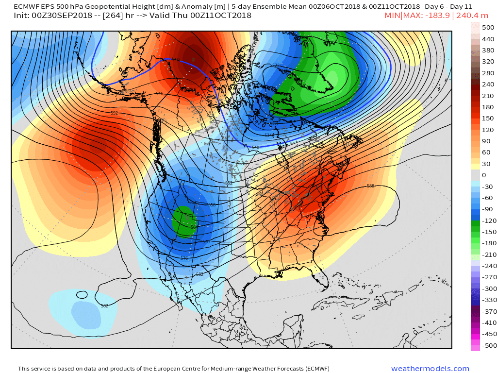 A prolonged stretch of unseasonably warm and humid weather will be with us through the first couple weeks of the month. Unfortunately, for fall foliage enthusiasts, for the second straight year, this will have a negative impact on the peak color season. Highs in the middle 80s and lows in the upper 60s to around 70° will be common during the period. Summer isn’t finished yet…
Permanent link to this article: https://indywx.com/2018/09/30/prolonged-stretch-of-unseasonably-warm-weather/
-
Filed under Autumn, Fog, Forecast Discussion, Forecast Models, Harvest'18, Rain, Summer, T-storms, Unseasonably Cool Weather, Unseasonably Warm, Windy
-
September 28, 2018
You must be logged in to view this content. Click Here to become a member of IndyWX.com for full access. Already a member of IndyWx.com All-Access? Log-in here.
Permanent link to this article: https://indywx.com/2018/09/28/video-pleasant-early-fall-weekend/
-
Filed under Autumn, Flooding, Florence, Forecast Discussion, Forecast Models, Heavy Rain, Rain, Summer, Tropics, Unseasonably Warm, Weather Videos
-
September 15, 2018
You must be logged in to view this content. Click Here to become a member of IndyWX.com for full access. Already a member of IndyWx.com All-Access? Log-in here.
Permanent link to this article: https://indywx.com/2018/09/15/florence-continues-to-impact-the-carolinas-mostly-dry-here/
-
Filed under Autumn, Flooding, Florence, Forecast Discussion, Forecast Models, Heavy Rain, Rain, Summer, T-storms, Tropics, Unseasonably Warm, Weather Rambles
-
September 14, 2018
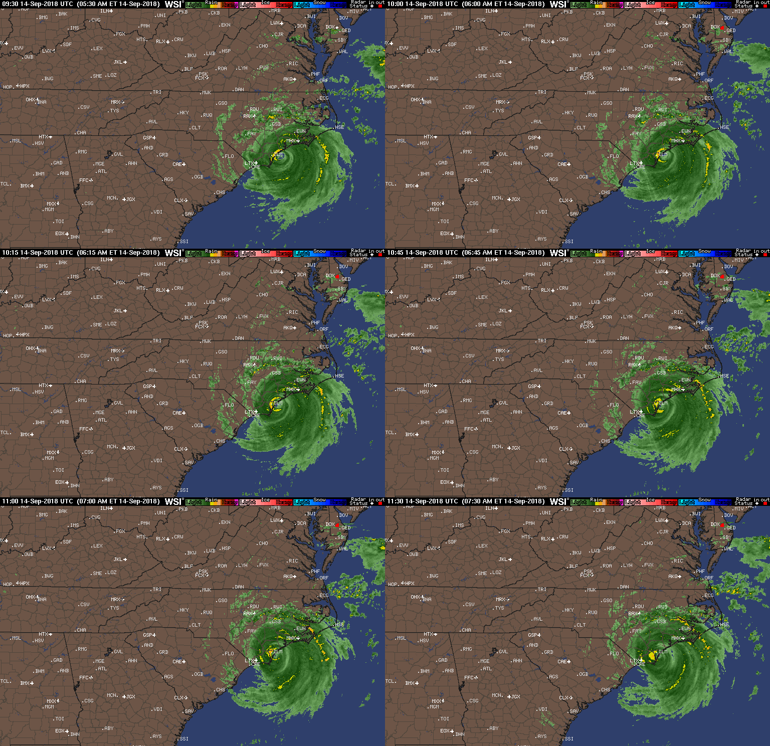
Florence made landfall around 7:15 this morning near Wrightsville Beach, NC. Within the past 30 minutes, a wind gust was reported to 105 MPH in Wilmington, NC.
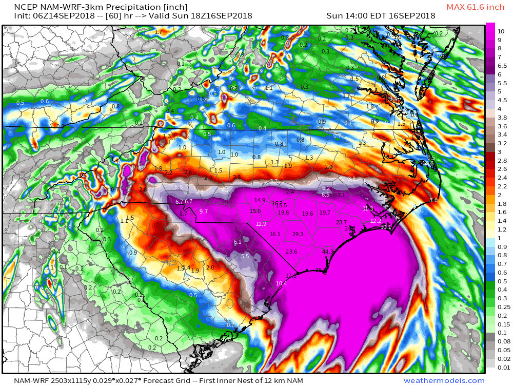
 Florence will crawl through the Carolinas this weekend and spread devastating flooding well inland- 20″ to 30″. Even the high ground of the North Carolina Blue Ridge will experience severe flooding Sunday into Monday- 6″ to 12″. These are forecast radar totals shown now through 2p Sunday. The Blue Ridge will see heavy rain continue into Monday evening.
 Back here on the home front, expect an extended stretch of dry and warm weather. Plentiful sunshine can be expected as we head into the weekend along with a warming trend- mid 80s and lows in the mid to upper 60s. High pressure will remain in firm control.
 The next item of excitement for our region will be from a cold front late next week. This will help increase shower and thunderstorm chances along with delivering cooler air next weekend.

Permanent link to this article: https://indywx.com/2018/09/14/florence-brings-devastating-flooding-to-the-carolinas-extended-dry-warm-stretch-here/
-
Filed under Flooding, Florence, Forecast Discussion, Forecast Models, Heavy Rain, JMA, Rain, Summer, Tropics, Unseasonably Cool Weather, Unseasonably Warm, Weather Videos
-
September 13, 2018
You must be logged in to view this content. Click Here to become a member of IndyWX.com for full access. Already a member of IndyWx.com All-Access? Log-in here.
Permanent link to this article: https://indywx.com/2018/09/13/all-eyes-on-florence-generally-quiet-here/
-
Filed under Flooding, Forecast Discussion, Forecast Models, Heavy Rain, Summer, T-storms, Tropics, Unseasonably Cool Weather, Unseasonably Warm, Weather Videos
-
September 4, 2018
You must be logged in to view this content. Click Here to become a member of IndyWX.com for full access. Already a member of IndyWx.com All-Access? Log-in here.
Permanent link to this article: https://indywx.com/2018/09/04/video-gordons-remnant-moisture-arrives-to-close-the-week/
-
Filed under Autumn, Forecast Discussion, Forecast Models, Heavy Rain, Labor Day Weekend, Rain, Summer, T-storms, Tropics, Unseasonably Warm, Weather Videos
-
September 3, 2018
You must be logged in to view this content. Click Here to become a member of IndyWX.com for full access. Already a member of IndyWx.com All-Access? Log-in here.
Permanent link to this article: https://indywx.com/2018/09/03/video-gordon-takes-aim-on-the-n-central-gulf-coast-unsettled-close-to-the-week/
You must be logged in to view this content. Click Here to become a member of IndyWX.com for full access. Already a member of IndyWx.com All-Access? Log-in here.
Permanent link to this article: https://indywx.com/2018/09/01/video-welcome-back-college-football-and-warrrrrr-eagle/
 II.) After a windy and warm Wednesday, scattered showers and thunderstorms will return Thursday. Not everyone will get wet, but a few locally heavy downpours can be expected.
 III.) The ridge will “flex its muscle” into early and middle parts of next week and promote an extended (and unusual) stretch of 80s. Don’t put those shorts away just yet…
 IV.) A “game changer” of a cold front will approach late next week with better chances of organized rain and storms followed by a return of more seasonal times…
 V.) Ingredients are in place for a significant shift in the pattern around the middle of October and colder times continue to look like they will return as we flip the page into Weeks 2-3.


 Accordingly, we would expect to see a deep trough across the west and ridging/ associated warmer pattern across the east. Sure enough, that’s what the modeling is painting.
 A prolonged stretch of unseasonably warm and humid weather will be with us through the first couple weeks of the month. Unfortunately, for fall foliage enthusiasts, for the second straight year, this will have a negative impact on the peak color season. Highs in the middle 80s and lows in the upper 60s to around 70° will be common during the period. Summer isn’t finished yet…
 Florence will crawl through the Carolinas this weekend and spread devastating flooding well inland- 20″ to 30″. Even the high ground of the North Carolina Blue Ridge will experience severe flooding Sunday into Monday- 6″ to 12″. These are forecast radar totals shown now through 2p Sunday. The Blue Ridge will see heavy rain continue into Monday evening.
 Back here on the home front, expect an extended stretch of dry and warm weather. Plentiful sunshine can be expected as we head into the weekend along with a warming trend- mid 80s and lows in the mid to upper 60s. High pressure will remain in firm control.
 The next item of excitement for our region will be from a cold front late next week. This will help increase shower and thunderstorm chances along with delivering cooler air next weekend.