Category: Summer

Long Range Update: Unseasonably Refreshing Pattern Set To Rule The Day…

A few days into June, Indianapolis is running half a degree below normal and 0.57″ below normal in the rainfall department.

Coolest anomalies have been focused over the Great Lakes region. A good portion of the region is running below average early on this month in the rainfall department, with the exception being the eastern Great Lakes.

As we look ahead, the MJO is forecast to move through Phases 3 and 4 with its eyes set on Phase 5 late month.

The relative “transient” warmth now lines up perfectly with Phase 3, but note the cooler pattern that Phase(s) 4-5 typically delivers.
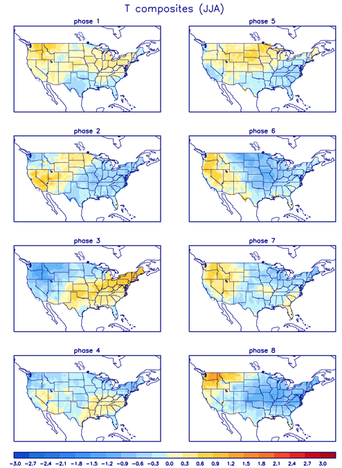
As a side note, there’s reason to believe this rather hyper MJO will continue, carrying us into the cooler Phases 6-8 as we move into the heart of the summer.

To no surprise, the medium and long range guidance is going towards a cooler than normal and unseasonably refreshing look as we move through the mid month period and into late June.
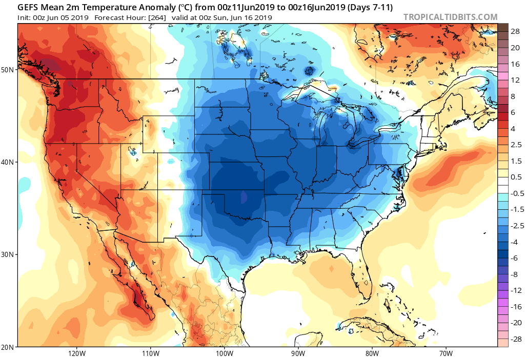
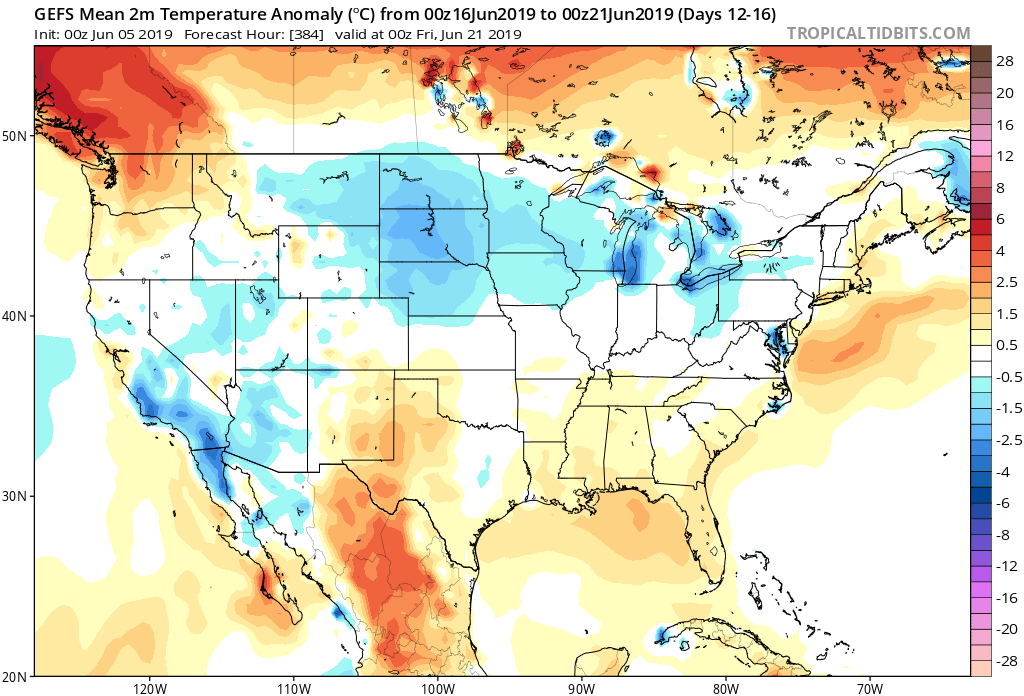
The Climate Forecast System agrees:

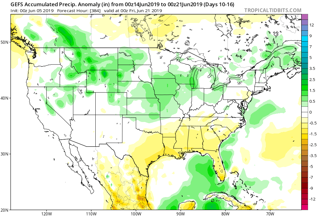
As for rainfall, we’ll use our short-term updates to handle the Weeks 1-2 period, but as we look ahead to mid-June, the pattern is expected to feature above normal rainfall across the Mid West and into the Ohio Valley and Great Lakes.
Permanent link to this article: https://indywx.com/2019/06/05/long-range-update-unseasonably-refreshing-pattern-set-to-rule-the-day/

Evening All-Access Video: It’s Not All “Doom And Gloom;” Updated Thoughts Around Late Week-This Weekend…

You must be logged in to view this content. Click Here to become a member of IndyWX.com for full access.  Already a member of IndyWx.com All-Access?  Log-in here.

Permanent link to this article: https://indywx.com/2019/06/04/evening-all-access-video-its-not-all-doom-and-gloom-updated-thoughts-around-late-week-this-weekend/

VIDEO: Unsettled Weather Returns After A Pleasant Open To The Work Week…

You must be logged in to view this content. Click Here to become a member of IndyWX.com for full access.  Already a member of IndyWx.com All-Access?  Log-in here.

Permanent link to this article: https://indywx.com/2019/06/03/video-unsettled-weather-returns-after-a-pleasant-open-to-the-work-week/

Needed 48 Hour Break From The Rain; Unfortunately, Heavy Rain Returns Later This Week…

You must be logged in to view this content. Click Here to become a member of IndyWX.com for full access.  Already a member of IndyWx.com All-Access?  Log-in here.

Permanent link to this article: https://indywx.com/2019/06/02/needed-48-hour-break-from-the-rain-unfortunately-heavy-rain-returns-later-this-week/

VIDEO: Severe Weather Potential Later Today; Discussing The June Pattern…

You must be logged in to view this content. Click Here to become a member of IndyWX.com for full access.  Already a member of IndyWx.com All-Access?  Log-in here.

Permanent link to this article: https://indywx.com/2019/06/01/video-severe-weather-potential-later-today-discussing-the-june-pattern/

VIDEO: Gusty Saturday Storms; Wet Pattern Returns Next Week After 3-Day Break…

You must be logged in to view this content. Click Here to become a member of IndyWX.com for full access.  Already a member of IndyWx.com All-Access?  Log-in here.

Permanent link to this article: https://indywx.com/2019/05/31/video-gusty-saturday-storms-wet-pattern-returns-next-week-after-3-day-break/

Short-Term Video Update: How Long Do Storms Last Tonight? Strong Storms Saturday PM?

You must be logged in to view this content. Click Here to become a member of IndyWX.com for full access.  Already a member of IndyWx.com All-Access?  Log-in here.

Permanent link to this article: https://indywx.com/2019/05/30/short-term-video-update-how-long-do-storms-last-tonight-strong-storms-saturday-pm/

VIDEO: Scattered Storms This Evening; Cooler Pattern To Open June…

You must be logged in to view this content. Click Here to become a member of IndyWX.com for full access.  Already a member of IndyWx.com All-Access?  Log-in here.

Permanent link to this article: https://indywx.com/2019/05/30/video-scattered-storms-this-evening-cooler-pattern-to-open-june/

June Outlook: Does The Wet Pattern Continue?

Averages for June are as follows:

  • Average Low: 62.1 (f)
  • Avearge High: 81.9 (f)
  • Average Rain: 4.25″
  • Average Snow: 0.00″

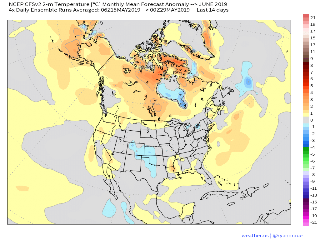
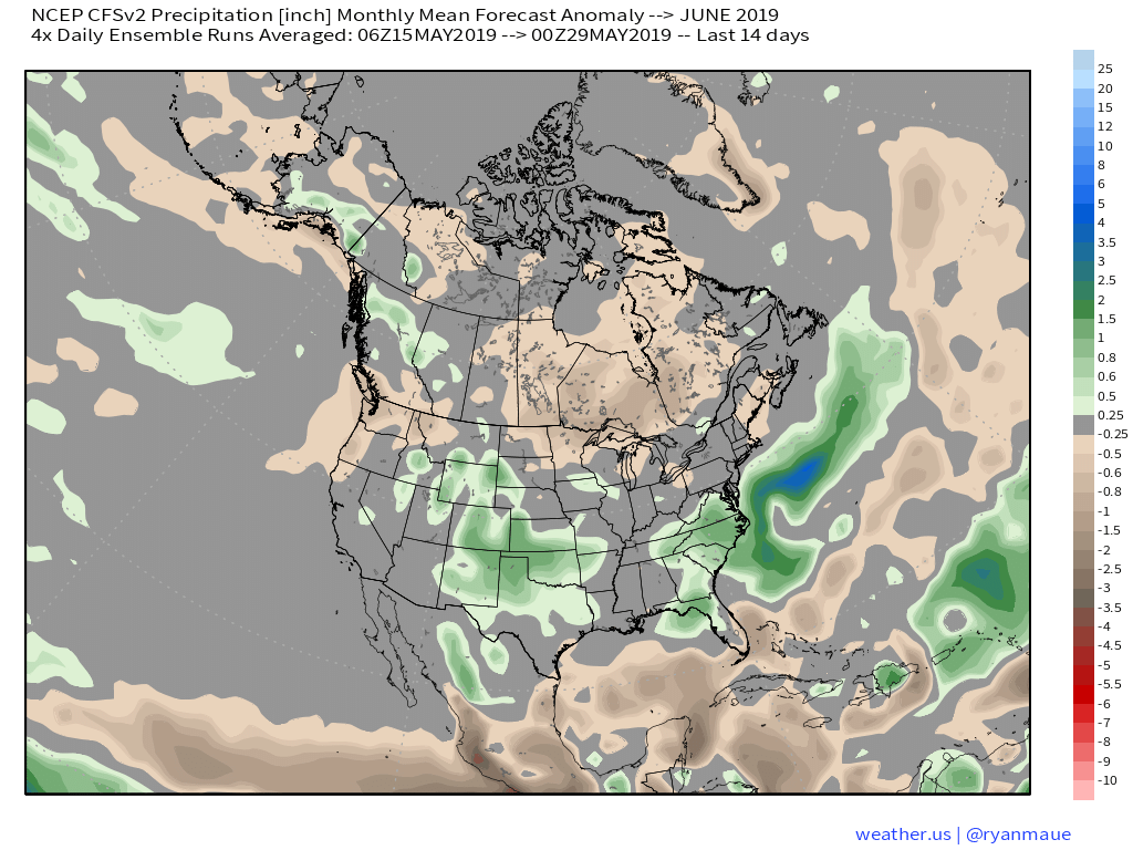
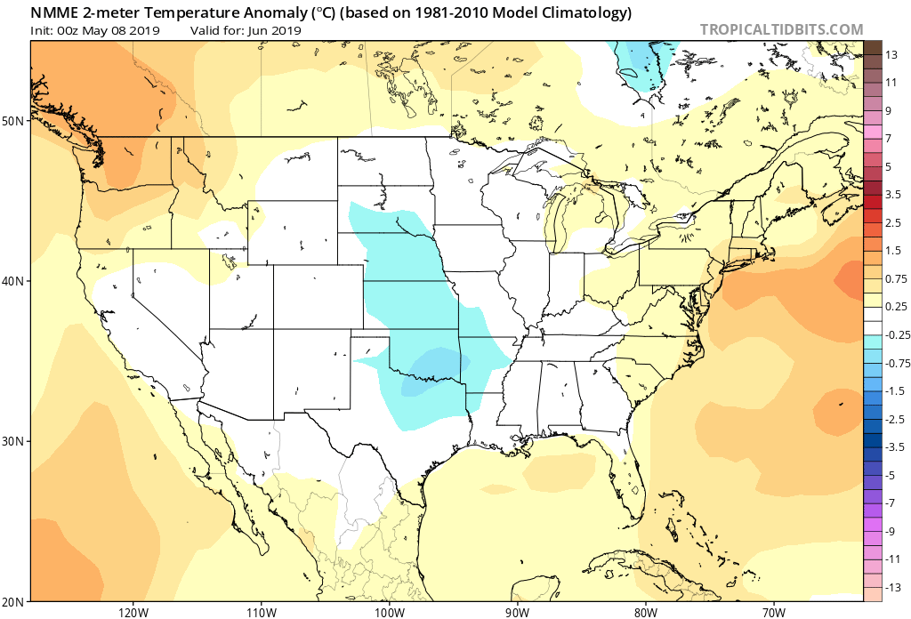
As we head to the 50-yard line of 2019 (already?!), we’re of the belief we’re looking at a cooler than normal month of June with close to average rainfall. Before we get into our reasoning of such, let’s look at a few snap shots of the latest data:

CFSv2

JMA

NMME

Though we can’t show it, the longer range European model paints a cool, wet picture from the south-central into the Plains and portions of the Northeast.

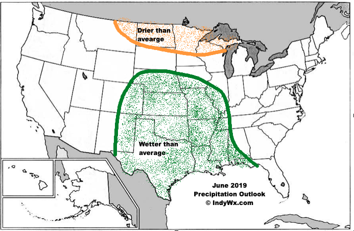
Given the analogs we’ve looked over with weak El Ninos along with similar MJO pulses, we’ve built a generally wet and cool June forecast nationally:

Ridging should support warmer than average conditions across the Southeast and Pacific Northwest, along with a rather widespread cooler than normal regime through the south-central Plains into the Great Lakes and New England. Unfortunately, we think wetter than normal conditions remain from the Delta into the central Plains. With that said, conditions seem more favorable for planting through a large portion of the OHV region.

Permanent link to this article: https://indywx.com/2019/05/29/june-outlook-does-the-wet-pattern-continue/

VIDEO: Storms Continue Today; Discussing MJO Influence As We Move Into Early June…

You must be logged in to view this content. Click Here to become a member of IndyWX.com for full access.  Already a member of IndyWx.com All-Access?  Log-in here.

Permanent link to this article: https://indywx.com/2019/05/29/video-storms-continue-today-discussing-mjo-influence-as-we-move-into-early-june/

IndyWx.com