Category: Summer
|
Sun.
|
Mon.
|
Tue.
|
Wed.
|
Thr.
|
Independence Day
|
Sat.
|
|

|

|

|

|

|

|

|
|
70/ 83
|
72/ 88
|
72/ 85
|
63/ 78
|
59/ 74
|
51/ 77
|
54/ 82
|
|
Light
|
Light
|
Light
|
Light
|
– – –
|
– – –
|
– – –
|
Most of today will be dry and though we’ll be continued warm and humid, we’ll have just enough breeze to make it feel comfortable out. Better rain chances will remain down state late morning into the afternoon. While a scattered shower or storm is possible across central Indiana, most will remain rain-free today we think. We’re going to have to monitor a couple of complexes of strong to severe thunderstorms late tonight and again Monday night off to our northwest. Short-term modeling keeps both complexes just to our north, but we’ll keep a close eye on things moving forward. Rain chances remain through mid week before a big push of cooler, drier air blows into town for the long holiday weekend. Temperatures will run much cooler than average and provide a taste of early fall during what traditionally is the dog days of summer!
Permanent link to this article: https://indywx.com/2014/06/29/storm-chances-remain-before-we-turn-much-cooler/
Thr. Fri. Sat. Sun. Mon. Tue. Wed. 65/ 83 64/ 85 67/ 86 71/ 87 73/ 90 73/ 89 64/ 79 – –…
You must be logged in to view this content. Click Here to become a member of IndyWX.com for full access. Already a member of IndyWx.com All-Access? Log-in here.
Permanent link to this article: https://indywx.com/2014/06/26/nice-day-shaping-up/
Mon. Tue. Wed. Thr. Fri. Sat. Sun. 68/ 88 69/ 81 66/ 82 61/ 84 65/ 83 68/ 84 70/ 87 Light Light…
You must be logged in to view this content. Click Here to become a member of IndyWX.com for full access. Already a member of IndyWx.com All-Access? Log-in here.
Permanent link to this article: https://indywx.com/2014/06/23/splash-and-dash-storms-to-open-the-work-week/
|
Sun.
|
Mon.
|
Tue.
|
Wed.
|
Thr.
|
Fri.
|
Sat.
|
|

|

|

|

|

|

|

|
|
63/ 85
|
66/ 87
|
69/ 80
|
65/ 83
|
63/ 83
|
69/ 80
|
66/ 83
|
|
Light
|
Light
|
Moderate
|
Light
|
Light
|
Moderate
|
Light
|
Though we officially just welcomed in summer, we’ve been in meteorological summer since June 1st. The meteorological seasons include June through August for summer, September through November for fall, December through February for winter, and March through May for spring. This week we’ll feel very much like summer, including seasonable temperatures and plenty of rain and storm chances! Coverage of those showers and thunderstorms will be widely scattered today and Monday, primarily during the afternoon and evening hours. While everyone won’t get wet, some locally heavy downpours are possible. Looking ahead, we target better chances of more widespread showers and thunderstorms Tuesday and again Friday. The week ahead stands to be another wet one on the precipitation front, including widespread 1.5″-2″ totals during the course of the upcoming 7 days on average.
Permanent link to this article: https://indywx.com/2014/06/22/feeling-like-summer-2/
-
Filed under 7-Day Outlook, Forecast, Forecast Discussion, Forecast Models, GFS, Heavy Rain, Rain, Severe Weather, Summer, T-storms
-
June 19, 2014
Thr. Fri. Sat. Sun. Mon. Tue. Wed. 70/ 87 69/ 84 66/ 85 64/ 86 66/ 89 66/ 80 66/ 78 Light Light…
You must be logged in to view this content. Click Here to become a member of IndyWX.com for full access. Already a member of IndyWx.com All-Access? Log-in here.
Permanent link to this article: https://indywx.com/2014/06/19/remaining-active/
-
Filed under 7-Day Outlook, Forecast, Forecast Discussion, Hail, Heavy Rain, NAM Model, Rain, Severe Weather, Summer, T-storms, Unseasonably Warm, Weather Videos, Windy
-
June 17, 2014
Good afternoon! We wanted to cut a video discussing our thinking around timing and primary threats from any severe weather that gets going across central Indiana tomorrow evening.

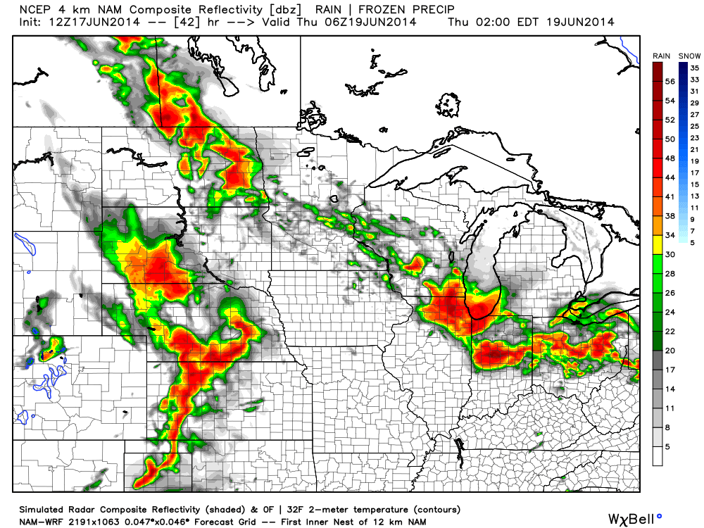
4km NAM forecast radar suggests a stormy time of things Wednesday evening. We discuss in your afternoon video update!
Permanent link to this article: https://indywx.com/2014/06/17/focusing-on-wednesday-evening-severe-potential/
Tue. Wed. Thr. Fri. Sat. Sun. Mon. 70/ 90 71/ 89 71/ 89 70/ 86 70/ 86 70/ 84 67/ 80 – –…
You must be logged in to view this content. Click Here to become a member of IndyWX.com for full access. Already a member of IndyWx.com All-Access? Log-in here.
Permanent link to this article: https://indywx.com/2014/06/17/hot-and-humid/
Mon. Tue. Wed. Thr. Fri. Sat. Sun. 68/ 85 70/ 89 71/ 90 70/ 89 71/ 85 68/ 86 67/ 84 Light –…
You must be logged in to view this content. Click Here to become a member of IndyWX.com for full access. Already a member of IndyWx.com All-Access? Log-in here.
Permanent link to this article: https://indywx.com/2014/06/15/very-humid-splash-and-dash-storms/
|
Fri.
|
Sat.
|
Sun.
|
Mon.
|
Tue.
|
Wed.
|
Thr.
|
|

|

|

|

|

|

|

|
|
58/ 71
|
49/ 73
|
53/ 82
|
67/ 82
|
69/ 87
|
70/ 87
|
69/ 83
|
|
Light
|
– – –
|
– – –
|
Moderate
|
Light
|
– – –
|
Light
|
A noisy thunderstorm rolled through the northern suburbs last night. I was awaken from a deep sleep around 12:30 to plenty of lightning, thunder, and heavy rain. While there are a couple showers around this morning, those will track east rather quickly and a pleasant northwest wind will usher in amazingly cool and refreshing air for this time of year. Simply put (yet again) today and Saturday will feature weather that just cannot get any better this time of year. We forecast many outlying communities away from the city to reach the upper 40s Saturday morning and highs both today and Saturday will only climb into the lower 70s. Ahhh, anyone else craving fall?! For those summer lovers, have no fear as heat and humidity will build late in the weekend and really set the tone for the week ahead. Additionally, a couple round of showers and heavy thunderstorms will be possible next week. Right now we target Monday and Thursday for best chances of heavy rain.
Permanent link to this article: https://indywx.com/2014/06/13/perfect-bonfire-weather/
-
Filed under 7-Day Outlook, Flooding, Forecast, Forecast Discussion, Forecast Models, GFS, Hail, Heavy Rain, Rain, Severe Weather, Summer, T-storms, Weather Videos
-
June 2, 2014
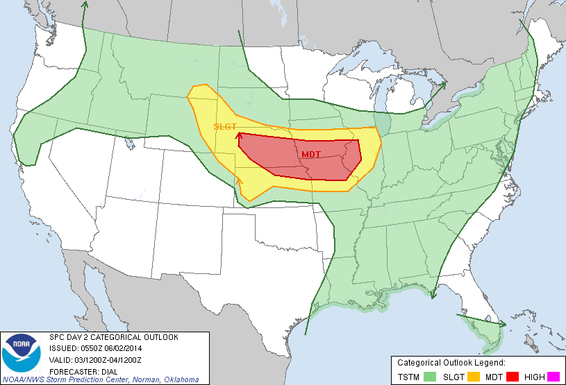
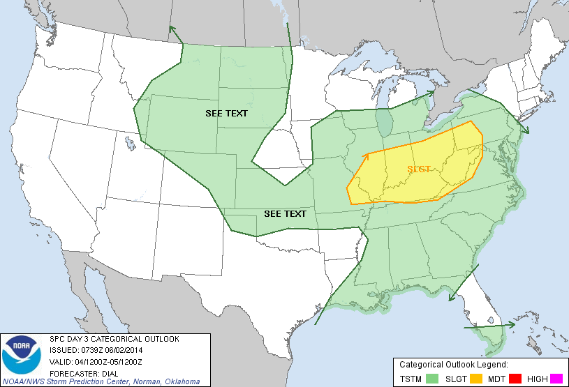
An active few days lie ahead though it won’t rain and storm the entire time, and many dry hours can be expected over the course of the next few days. The video covers the details below!

Tuesday is shaping up to be a very active severe weather day to our west.

Wednesday will feature severe weather chances across the Ohio Valley.
Permanent link to this article: https://indywx.com/2014/06/02/monday-morning-video-update-severe-weather-potential-and-heavy-rain/

