Category: SST Discussion

LR Update: Thanksgiving And Early December…

Updated 11.09.23 @ 10:49a

With Thanksgiving only 2 weeks from today (incredibly hard to believe), we’re able to start to get a better idea on the overall weather pattern as the “official” kickoff to the holiday season nears. The first point we want to drive home is that we should begin to see a much more active regime evolve during this 2 week period. From a temperature perspective, the pattern overall continues to look milder than average, but there will be a couple opportunities for transient pops of colder air, potentially around the all-important Thanksgiving holiday, itself.

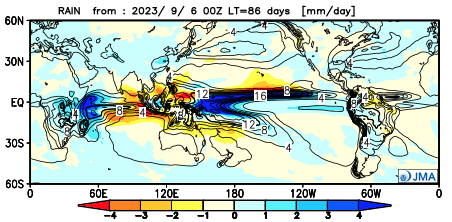
Note how modeling sees the more active pattern evolving over the next 3-4 weeks (green represents above normal precipitation). – A significant change not only for our neck of the woods but certainly for our friends and neighbors down south (badly needed for a region suffering an expanding drought. Speaking of which, all of the dry/ droughty southern tier should reverse in significant fashion as the active Nino storm track gets going over the coming months. As the pattern continues to evolve into the ‘24 spring and summer, the south-central severe drought will be erased.

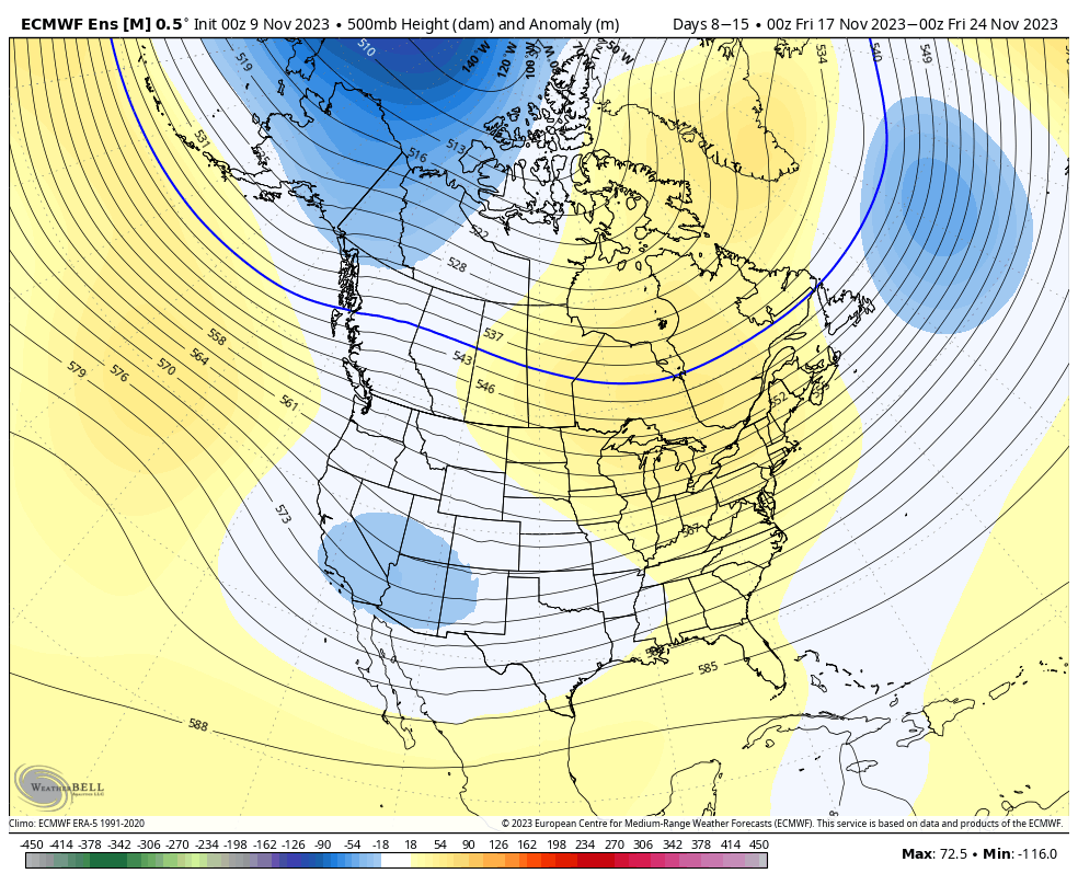
Despite attempts of troughs to roll into the Ohio Valley, they will struggle with staying power over the next 3-4 weeks. The latest JMA Weekly product and Euro/ GFS ensemble blend looks very solid given where the pattern drivers currently reside.

Week 1

Week 2

Weeks 3-4

The pattern drivers of a primarily positive EPO, negative PNA, and MJO in 8/1 (all unchanged from our post earlier this week) all suggest a predominant eastern ridge, western trough placement over the upcoming 2-3 weeks.

We’ll continue to keep close tabs on the regime, especially centered on 11/22 – 11/26.

Make it a great Thursday!

Side note: Confidence is increasing that this Nino will evolve into a central-based event which will up the chances of colder/ snowier prospects come late December and on into January. More on that later next week in a more extensive update specific to this transition.

Permanent link to this article: https://indywx.com/lr-update-thanksgiving-and-early-december/

Long Range Chatter; NEW JMA Data On Winter…

Updated 09.07.23 @ 7:15a

September has opened significantly warmer than normal across the northern Plains and to a lesser extent into the southern Plains and along the northern tier. Indianapolis is running 5° above average through the 6th. We’ll chip away some at those toasty anomalies over the course of the next week, but still anticipate the month finishing slightly warmer than normal as a whole. We’re also running dry- more than half an inch below normal to open the month.

As we look ahead to the upcoming couple of weeks, the combination of the Madden Julian Oscillation sneaking into Phase 4, combined with a strongly positive PNA should help lead to more of a trough across the eastern portion of the country.

The NEW JMA Weeklies show that trough and associated cooler pattern (not cold by any means, but instead slightly below normal overall) taking up shop in the Week 1 and Week 2 time period below.

Week 1

Week 2

The latest ensemble guidance is also on board with the more seasonal look, especially compared to how the month opened.

Week 1

Week 2

Overall, the dry start to the month is anticipated to persist through the remainder of September as a whole.

Jumping ahead, the JMA seasonal data also updated today. In short, the model shows a warm fall giving way to a warm start to the winter before potentially taking a colder mid and late winter turn. Still far too early to put much stock in the specifics from this distance. The next couple of months will be very telling with the migration (or lack thereof) of warmest central PAC sea surface temperatures along with modeled trends deeper into the winter. Long ways to go; stay tuned…

JMA meteorological (Dec. through Feb.) winter idea:

Upper air pattern
Temperature anomalies
Precipitation anomalies

Permanent link to this article: https://indywx.com/long-range-chatter-new-jma-data-on-winter/

VIDEO: ’23 – ’24 Snow Nugget; Rain Chances Return Tuesday Into Wednesday…

Updated 09.04.23 @ 8:58a

You must be logged in to view this content. Click Here to become a member of IndyWX.com for full access.  Already a member of IndyWx.com All-Access?  Log-in here.

Permanent link to this article: https://indywx.com/video-23-24-snow-nugget-rain-chances-return-tuesday-into-wednesday/

Initial Analog Set For Winter ’23 – ’24…

Updated 09.03.23 @ 9:22a

The extended stretch of quiet weather has given us time to finalize the initial set of analogs we’ll lean in on for the upcoming winter. Speaking of that, our annual Winter Outlook will be published Friday, October 27th.

While long range seasonal models differ on the placement of warmest sea surface temperature (SST) anomalies, we’re refraining from going “all-in” on a modoki Nino event as of now. This is something that no doubt will have our attention as we go through the course of the next several weeks. It’ll be interesting to watch the trends. The modoki, or central based, warm event would go a long way in upping the ante for a colder, stormier winter, locally. This is something that’s possible but we still have more questions than answers with how this evolves.

SST configuration as of September 1, 2023:

Our initial set of analogs includes the following years:

  • 1957-1958
  • 1972-1973
  • 1991-1992
  • 2002-2003
  • 2009-2010
  • 1982-1983
  • 2015-2016

We’re looking at 1st year Nino events of moderate to strong intensity. (Most modeling peaks this event in the +1.5 to +2 range in Nino region 3.4). In addition, we’re also looking at critical SST configuration in the NPAC and northwest Atlantic. Out of the list above, heaviest focus as of now centers on ’82-’83, ’91-’92, ’02-’03, ’09-’10, and ’15-’16.

A blend of those years gives us the following temperature and precipitation pattern for meteorological winter:

Temperature

Precipitation

There’s a lot more that goes into our seasonal outlooks than simply taking a blend of analogs, but this will serve as a nice starting point from this distance. It’ll be very interesting to watch the migration (or lack thereof) of warmest SSTs currently “tucked in” to Nino regions 1+2 and 3 into potentially a more central, or region 3.4 event.

Make it a great Labor Day weekend and know we’ll have much more to come in the weeks ahead on our winter ’23 – ’24 thoughts…

Permanent link to this article: https://indywx.com/initial-analog-set-for-winter-23-24/

Different Flavors Of El Niños And Impacts On The Winter…

Updated 07.14.23 @ 10:34a

After a rare triple dip La Niña, significant changes have taken place in the equatorial Pacific this past spring and summer. The question isn’t “if” we’re dealing with an El Niño this fall and winter, but rather what type, or “flavor” of Nino we get to enjoy.

(A quick piece of advice for anyone viewing winter outlooks that are being published ridiculously early: be skeptical to any sources “broad-brushing” the outlook by labeling it simply as an “El Nino winter”).

Like we say with every seasonal outlook it seems, each Nina, Nino, or even neutral events have their own characteristics. No single event is identical. While we can gain valuable insights that can help build the foundation of what lies ahead through looking back at the past, undoubtedly, every year will have a few surprises. It’s our job to try and limit those surprises the best we can. 😉

A look at the current sea surface temperature (SST) configuration shows the warmest anomalies tucked in to Nino 3 and Nino 1+2.

Simply put, if this look continues this fall and into the early winter, it’s a warm to very warm signal for winter, locally.

The million dollar question is how the early stages of this Nino evolves in the coming weeks and next few months. There’s reason to believe there’s a chance this transitions into more of a central based, or “Modoki” El Niño event by winter. If that’s the case, we’ll have to up the ante for colder, more wintry conditions.

(You can read more about Modoki El Niño events here).

While still a bit early to put too much stock in any of the seasonal products for winter, it is interesting to see how the latest European seasonal model is trending as we move into the Nov through Jan timeframe below.

Stay tuned. We’ll really begin to firm up preliminary meteorological winter (Dec through Feb) thoughts over the course of the next couple months.

Permanent link to this article: https://indywx.com/different-flavors-of-el-ninos-and-impacts-on-the-winter/