Category: SOI Index

Still On Track For A Cooler Pattern As Mid-July Approaches?

Through the first few days of July, it’s off to a scorching start across the Mid West, Ohio Valley, and into the Southeast. Officially, Indianapolis is running more than 4 degrees above normal through the first (4) days of the month.

As we look ahead, we wanted to review the latest data to see if the expected cooler pattern is still on deck as we approach mid month.

The short answer is yes, but after we review the upcoming 500mb transition, we have further evidence for a cooler (or at least “less hot”) change. Note how the European ensemble paints a picture of the upper ridge being directly overhead in the current term towards more of a NW flow aloft by Days 10-15.


This should result in a transition to a temperature pattern that turns more seasonable and at times even cooler than normal as we rumble into the mid-July period. The other item of note is that we’ll have to be watchful for the potential of northwest to southeast tracking clusters of storms with the heat ridge back to the southwest. This threat will come after a drier period of weather that develops the 2nd half of this weekend into much of next week.

Does the data line up with what other pattern drivers would suggest? Well, the recent big hit to the SOI would back up the idea that a trough and associated cooler pattern looms around 10-15 days after the fact (sometime around the 9th-14th time frame).

Finally, the MJO moving from Phase 1 to Phase 2 this time of year would also suggest the cooler idea has merit.

With all of that said, we continue to believe we’re on a track for a pattern that will promote a backing off of the significant heat in the days (and weeks) ahead. Especially as mid-July approaches, the temperature pattern should turn seasonable to slightly cooler than normal while the ante is also upped for the chance of multiple storm complexes to impact the area in that NW flow aloft.

Permanent link to this article: https://indywx.com/2019/07/05/still-on-track-for-a-cooler-pattern-as-mid-july-approaches/

VIDEO: Heat And Humidity Carry The Day Now; Looking Ahead To The 1st Half Of July…

You must be logged in to view this content. Click Here to become a member of IndyWX.com for full access.  Already a member of IndyWx.com All-Access?  Log-in here.

Permanent link to this article: https://indywx.com/2019/06/27/video-heat-and-humidity-carry-the-day-now-looking-ahead-to-the-1st-half-of-july/

Snow Update And Looking Ahead Towards Mid-March…

Snow will overspread central Indiana through the late morning hours into the afternoon.

While the overall idea where the accumulating snow would fall was a good one from early week, our initial expected amounts won’t come to fruition. The reason? The storm system is much weaker and faster moving than originally modeled.

Accordingly, this is a 1″ to 2″ type event for most of the area. The majority of the snow will fall from noon to 5p.

A period of snow will scoot across central Indiana from late morning into the early evening hours.

This same storm system will be responsible for a severe weather outbreak, including the possibility of a couple of strong tornadoes, across the Deep South this afternoon.

Back here on the home front, MUCH colder air will pour into the region this evening, remaining in place into the new work week. Back-to-back nights with lows in the upper 0s to lower 10s can be expected across central Indiana Monday and Tuesday mornings.

This is all part of the overall colder than normal first half of March, powered by the SOI crash (several week ago), deeply negative EPO, and MJO rumbling through the cold phases.

Additional storm dates to keep note off include Thursday night into Friday (more of a wintry threat with the 3/7-3/8 system) and Saturday into Sunday (potential strong thunderstorms with the system on 3/9-3/10).

Looking ahead, it still appears the mid-March warm-up is on track as the EPO flips to positive.

With that warm-up will also come a return of heavier precipitation events and a continued overall active storm track across the region. Precipitation looks to run above average for the mid-month stretch.

We’ll dig deeper early week on what lies ahead as we close the month of March and look ahead towards April…

Permanent link to this article: https://indywx.com/2019/03/03/snow-update-and-looking-ahead-towards-mid-march/

VIDEO: Updated Thoughts Around This Weekend’s Winter Storm And The Pattern Through March…

Here’s our latest thinking around this weekend’s winter storm and a long range update through the month of March…

You must be logged in to view this content. Click Here to become a member of IndyWX.com for full access.  Already a member of IndyWx.com All-Access?  Log-in here.

Permanent link to this article: https://indywx.com/2019/02/28/video-updated-thoughts-around-this-weekends-winter-storm-and-the-pattern-through-march/

It Was A Case Of Delayed, But Not Denied…

While arriving later than originally expected (recall we originally thought the cold, wintry pattern would start on the 18th), it sure appears as if this was a case of “delayed, but not denied.”

The latest GFS and European ensembles are keying in on a significant pattern change as we put a wrap on February and open March. (Looks like we were about a week early in jumping on the cold bandwagon).

First and foremost, there’s excellent overall agreement amongst data (increases confidence significantly during the medium to long range period).

Days 1-5: Southeast ridge continues to dominate during the short-term period and there’s no high-latitude blocking to speak of. This suggests storms will continue to “cut” northwest of the region and place central Indiana in the “warm” sector, with transient, backlash cold/ snow potential.

Days 6-10: Significant changes begin to take place as heights (ridging) builds across AK. This is important as it can help “dislodge” late season cold air (and send it southeast). The SE ridge is also in the process of getting squashed during this period. We’ll likely transition away from the moisture-laden storm systems and replace with faster, overall weaker, systems that will be more capable of producing wintry precipitation.

Days 12-16: A total transformation of the pattern has taken shape since the Day 1-5 period. The new ‘mean’ trough position takes up shop across the East with the AK ridge continuing to dislocate late season arctic air southeast. The GEFS also shows a reflection of a southwest ridge which can be helpful in the overall storm track that could potentially deliver more “meaningful” wintry systems across the OH and TN Valleys as we get into the first couple weeks of meteorological spring.

Side notes: We’ve reviewed the crashing SOI index and this increases our confidence in a much colder pattern developing (typically takes place around 10-12 days after the crash begins). We’ve noted the deeply negative values against the base state which would suggest the cold pattern should continue for some time. We still believe the pattern remains colder than average, overall, through the 1st half of March.

The latest deeply negative EPO adds fuel to the fire in the idea of a cold open to March.

Given this, there should be no surprise to see the cold anomalies showing up on the latest medium-long range ensemble guidance:

It sure appears March will come in like a lion; will it go out like a lamb?

Permanent link to this article: https://indywx.com/2019/02/20/it-was-a-case-of-delayed-but-not-denied/

Evening Video Update: Snow, Storms, And A Major Pattern Shift On The Horizon…

You must be logged in to view this content. Click Here to become a member of IndyWX.com for full access.  Already a member of IndyWx.com All-Access?  Log-in here.

Permanent link to this article: https://indywx.com/2019/02/19/evening-video-update-snow-storms-and-a-major-pattern-shift-on-the-horizon/

Sunday Morning Video Update…

A wintry mix this morning sets the stage for another active week of weather across central Indiana. We also look forward to late Feb and early March…

You must be logged in to view this content. Click Here to become a member of IndyWX.com for full access.  Already a member of IndyWx.com All-Access?  Log-in here.

Permanent link to this article: https://indywx.com/2019/02/17/sunday-morning-video-update-3/

Disruption In The Force Or Just Noise?

Our longstanding call has been for the period of early to mid-February to feature a “transitional” pattern before locking into one last cold, stormy period for the winter during the 2/18 through 3/10 time frame. The reasoning behind this idea has been stated multiple times in previous updates.

However, there’s no denying that today’s 12z ensemble update (both from the GEFS and EPS) has rattled us a bit with that idea. The GEFS and EPS are in very good agreement at 500mb:
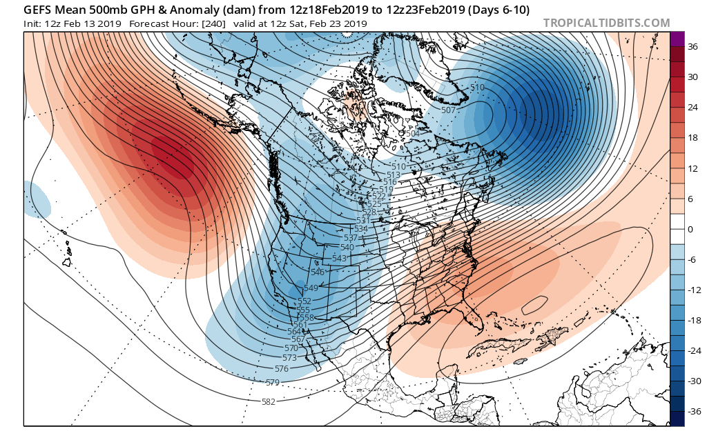
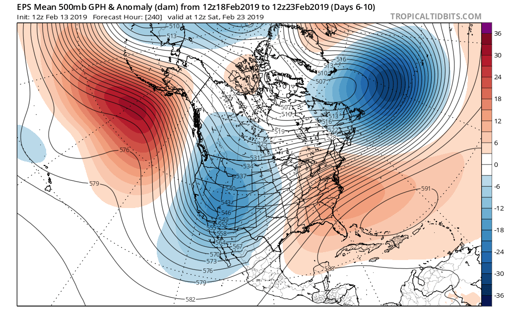
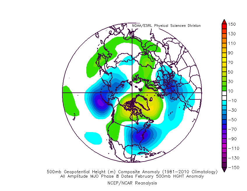
This is in the face of Phases 8 and 1 from an MJO perspective:
Furthermore, the sudden negative “jolt” in the SOI (Southern Oscillation Index) also favors a significant period of cold, stormy weather, locally:

Please understand this isn’t us changing our ongoing forecast that’s out there, but instead making sure we’re presenting a 100% transparent idea from two of the most highly respected ensemble products out there (that have been generating a lot of attention today with this output). We prefer to give it another few days before altering our medium and longer term forecast to see if any sort of consistency can develop.

At the end of the day, this may be a situation where the resistance from the SE ridge puts up enough of a fight to lead to a lack of “suppression” from the hyperactive storm track currently in place, and instead continuing the busy storm track into the TN and Ohio Valley regions as cold air presses.

Rest assured, you’ll be the first to know if a wholesale medium to long range forecast change is required here. Stay tuned.

Permanent link to this article: https://indywx.com/2019/02/13/disruption-in-the-force-or-just-noise/

VIDEO: Another Gorgeous Weekend Awaits And We Look Ahead To September…

You must be logged in to view this content. Click Here to become a member of IndyWX.com for full access.  Already a member of IndyWx.com All-Access?  Log-in here.

Permanent link to this article: https://indywx.com/2017/08/11/video-another-gorgeous-weekend-awaits-and-we-look-ahead-to-september/

Confidence Increasing On Leader-Follower Event; But Details Murky…

A look over model data from overnight suggests we need to focus on a “leader-follower” event for the upcoming weekend.

We’re confident the “leader” player is a rain maker for IN in the Thursday afternoon-Friday time frame (.40-.70 rainfall potential).

Source: Tropicaltidbits.com

Source: Tropicaltidbits.com

As we progress into the second half of the weekend, details get quite murky on the specifics with the secondary (follower) area of low pressure that develops along a pressing arctic front.

As we’ve been discussing, model solutions will vary within each respected model (GFS, Euro, GEM, etc.) in a run-to-run fashion.  Stack them up against one another, and we’ll likely continue to have as many different solutions as we do models that we’re looking at.  It’s a byproduct of a pattern transition and that crashing SOI (which is still crashing this morning, btw).  Case in point, note the various options below for Sunday.

The GFS takes a low from southern AL into the coastal plain of NC. Source: Tropicaltidbits.com

The GFS takes a low from southern AL into the coastal plain of NC. Source: Tropicaltidbits.com

The Canadian is a blend of the GFS and European as it tracks low pressure from eastern LA into the central Appalachians. Source: Tropicaltidbits.com

The Canadian is a blend of the GFS and European as it tracks low pressure from eastern LA into the central Appalachians. Source: Tropicaltidbits.com

The European is most aggressive in the west track as it takes low pressure from the MO bootheel into northern IN. Source: Tropicaltidbits.com

The European is most aggressive in the west track as it takes low pressure from the MO bootheel into northern IN. Source: Tropicaltidbits.com

Past experience with similar patterns certainly leads us to lean more towards the European/ Canadian solution over the GFS from this distance.  We know that models have their own biases though.  Time and time again the GFS bias is to rush things along a bit too much from this distance and become too progressive.  On the flip side, the European is notorious for dragging it’s heels a bit and, at times, can be too slow with bringing energy out of the west.  This in return impacts things downstream…

From this distance, we still can’t be too specific with snow/ precipitation prospects Sunday.  While confidence is increasing on at least some sort of snow to contend with, the significance of such isn’t possible to iron out at the moment.  Much fine tuning will be required.  Stay tuned.

Permanent link to this article: https://indywx.com/2016/01/05/confidence-increasing-on-leader-follower-event-but-details-murky/

IndyWx.com