Category: snow

Questions Around Next Week’s Arctic Front…

Your complete 7-Day forecast can be found in the video to the right of this article.

We continue to keep a close eye on the developing weather situation here late next week.  Many questions remain in regards to the track, timing, and strength of the cold air associated with an arctic cold front that will result in record-breaking cold for portions of the country next week.  How much fight will the southeast ridge put up as the front progresses east?  Will we have to deal with a wave of low pressure along the arctic boundary, potentially leading to some wintry “mischief” around these parts?  We hope to give some clarity around those questions by looking at some of the latest data below.

First, let’s take a look at the various model solutions for late next week.  It should be noted that the latest run of the National Weather Service’s GFS forecast model has taken a turn to look more like the overnight run of the European forecast model and suggests we have to deal with a wave of low pressure moving through here Friday into Saturday of next week, leading to the threat of wintry precipitation.  Taken at face value, this would suggest the threat of an accumulating snow event for central Indiana Friday night into Saturday morning of next week.  This is in stark contrast to the 0z GFS run signaling dry, cold weather during the aforementioned time frame.

Here’s a look at the latest GFS solution, valid next Friday evening:

gfs_namer_180_1000_500_thick_s

There’s relatively good agreement in the GFS ensembles, but, again, we’ll have to fine tune the details.  It’s encouraging to see the agreement in the pattern evolution, though, this far out.

f192

Here’s a look at the latest European forecast, again valid for next Friday evening.

As we spoke about above, the 0z ECMWF run suggests we have to deal with a wave of low pressure in the cold air here next Friday into Saturday.  Similar to the latest run of the GFS model, there would be the potential of accumulating snow here.  The ensembles are on the left and the operational run is on the right.  The precise details will have to be ironed out, but we note relative agreement here.

Geopotential32at32500hPa_North32America_192

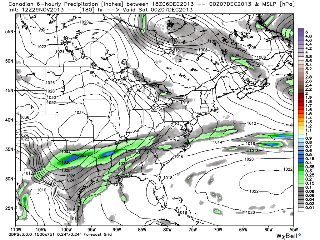
The latest Canadian forecast model also sees the wave of low pressure along the pressing arctic front, but suggests the wave is too far south to result in any sort of significant snowfall accumulation for central Indiana.  (As of this post time, the 12z Canadian ensemble package hadn’t arrived).

cmc_precip_mslp_east_31

So, with all of that said, we still have plenty of time to watch things unfold in the coming days.  What are we confident in as of today?

  • Brutally cold arctic air invading the northwest early in the week before slowly spreading east and south as we progress through the week.
  • We’ll be in a much warmer (though very brief) pattern here Thursday as highs zoom into the middle 50s to near 60 with rain.
  • We target the arctic front to blow through here during the day Friday.
  • While we’ll turn MUCH colder than normal next weekend, we aren’t looking at the brutality of the cold that our friends out west will have to deal with.

What are the answers that have to be ironed out this week?

  • Strength and depth of the cold air coming east.
  • Strength of the upper ridge over the Southeast US.
  • The resistance of the ridge will be crucial into determining where the “wintry precip. zone” sets up shop.

Permanent link to this article: https://indywx.com/questions-around-next-weeks-arctic-front/

QUICK Wednesday Evening Video Update

  I’ll try and have a more in-depth post later tonight.  Have a great evening!

You must be logged in to view this content. Click Here to become a member of IndyWX.com for full access.  Already a member of IndyWx.com All-Access?  Log-in here.

Permanent link to this article: https://indywx.com/quick-wednesday-evening-video-update/

Tuesday Night Video Update: Lake Enhanced Snow Showers

Tonight’s Video Highlights: Lake Effect Snow Showers And Squalls Set To Impact Central Indiana Coldest Thanksgiving In Years On Deck Eyeing The Potential Of An Arctic Invasion Next Week

You must be logged in to view this content. Click Here to become a member of IndyWX.com for full access.  Already a member of IndyWx.com All-Access?  Log-in here.

Permanent link to this article: https://indywx.com/tuesday-night-video-update-lake-enhanced-snow-showers/

Clouds Today; Snow Showers For The Big Travel Day

Good morning and happy Tuesday, Hoosiers!  Yesterday’s forecast went as planned with most folks not receiving any snowfall accumulation and a couple reports of a dusting to half an inch type snow.  We saw a couple local weather sources forecasting 1″ of snow and never understood that call as a lot of dry air had to be overcome initially.

Today will feature lots of clouds and another cold day as we watch a big southern storm begin to “make the curve” and impact the interior east.  Places as close as eastern Ohio will deal with heavy snow tonight and early Wednesday.  Additionally, locations as far south as east Tennessee will have accumulating snow by late tonight and early Wednesday.

Back here on the “home front” we’re looking at our next chance of snow arriving Wednesday afternoon.  The wind trajectory off Lake Michigan should allow a couple of lake-enhanced snow bands to push south into north-central Indiana, primarily from IND and points north.  It’s impossible to pinpoint with any degree of certainty the precise locations of these snow bands, but should your neighborhood end up under one of these snow squalls, don’t be surprised if you pick up a quick coating to 1″ of snow Wednesday afternoon/ evening.

Most model data (below) shows the lake-enhanced snow showers and embedded heavier squalls arriving Wednesday afternoon.  We’ll have a complete forecast update (and probable video) here later tonight.  Make it a great day.

hires_ref_indy_30snow1snow2

Permanent link to this article: https://indywx.com/clouds-today-snow-showers-for-the-big-travel-day/

Snow Talk

Good morning!  Some light snow is possible later this afternoon and tonight, but “light” is the key word and this shouldn’t amount to much, if any, accumulation across the majority of central Indiana. At most, we’re looking at a few communities that may see a dusting to half an inch type accumulation.  The latest high resolution data shows that we’re on the northern periphery of the storm system that will create all sorts of travel problems for our neighbors to our east and south in the days to come leading up to Thanksgiving.

hires_ref_ky_21

Additionally, we’ll keep a close eye on the wind trajectory coming off Lake Michigan Wednesday. It’s looking more and more likely that we’ll have to deal with some lake-enhanced snow showers and embedded heavier squalls here Wednesday as fresh arctic air pours south.  While we’re not expecting any sort of widespread, uniform, accumulation with this, the idea is that a few places (primarily from IND and points north) may see a quick coating to 1″ of snow Wednesday as some of these snow showers and locally heavier (but isolated) squalls drift south into north-central Indiana.  The latest GFS and NAM show the lake Michigan connection well and we’ll keep a close eye on the wind trajectory Wednesday.

nam_namer_060_1000_500_thick_sgfs_namer_063_1000_500_thick_s

Permanent link to this article: https://indywx.com/snow-talk/