Category: snow

Heavy Snow Warnings Ahead?

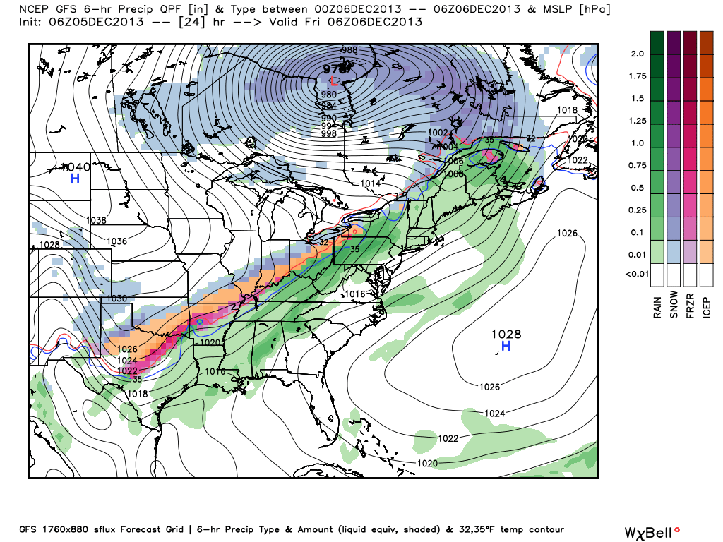
Good evening, Indy.  As of late morning, we began spreading the word, via our social media accounts, of the need to “beef up” snow totals.  Sure enough, latest data continues to point towards a snowier solution as of this update.  We now think widespread 5″-8″ snow totals will be common across most of central Indiana, but there will be heavier amounts where localized banding sets up.  As expected last night, the transition from sleet to snow was a rather rapid one this evening and we now think this will be an all-snow event for the majority of central Indiana through the duration of the storm.

While it won’t snow the entire upcoming 24 hours, waves of moderate to heavy precipitation will move in from the southwest and result in a widespread heavy snow event Friday.  There’s the chance the National Weather Service will transition Winter Storm Warnings over to Heavy Snow Warnings to account for the all-snow event ahead.

Latest raw data breaks down like this for Indianapolis:

  • GFS:  0.68″ (equates to nearly 7″ of snow on a 10:1 ratio)
  • NAM:  1.00″ (equates to 10″ of snow on a 10:1 ratio)
  • ECMWF: 0.58″ (equates to nearly 6″ of snow on a 10:1 ratio)

We’ll have your updated, custom-built, 7-Day forecast video posted shortly.  For now, here’s a look at what the local radar may look like tomorrow morning when we think another wave of moderate to heavy snow moves back into the region from the southwest:

NAM

Permanent link to this article: https://indywx.com/heavy-snow-warnings-ahead/

A Closer Look At Two Winter Weather Events.

Your updated, custom-built, Thursday video forecast can be found to the right of this post in the video player.  We typically update our video forecast during the evening.

Good Morning and happy Thursday!  We continue to monitor the latest data for our upcoming winter weather events.  It’s a busy time of things and by the looks of the overall pattern, I’ll have to stock up on the coffee for the weeks ahead.  Quite honestly, a very cold and snowy pattern appears to be setting up shop now through the end of the month.  Anyone dreaming of a white Christmas? 😉

Here are some quick bullet points for the upcoming few days:

  • Snow/ sleet overspreads the region this evening
  • (2) waves of snow/ sleet move through the region between this evening and Friday
  • Saturday will be a very cold and dry day
  • Renewed snow and potentially freezing drizzle move in Sunday
  • We continue to forecast a total of 3-6″ of snow between tonight and Monday morning

Latest forecast models continue to suggest temperatures fall through the day with a mixture of snow and sleet overspreading the region as early as 3-5pm from southwest to northeast.  We anticipate a rather rapid transition from sleet to snow, especially from IND and points north.  Here’s a look at the latest HRRR simulated radar data, valid tonight at 6 o’clock:

hrrr_ref_indy_15

Here’s a look at the GFS model.  (We think this particular model has a much better handle on things now that we’re closer to the event).  Note the “waves” of wintry precipitation forecast and we agree with this.  Wave #1 arrives for the evening rush with wave #2 arriving Friday morning into the afternoon.

GFS1GFS2GFS3

Additionally, after a very cold and dry Saturday, renewed accumulating snow will overspread the region Sunday, potentially ending as a mixture of light freezing rain or freezing drizzle atop the fresh snow Sunday afternoon.

GFS4GFS5

Permanent link to this article: https://indywx.com/a-closer-look-at-two-winter-weather-events/

Wednesday Morning Weather Rambles…

1.) Fog will hang tough this morning, but strong southerly winds will blow this afternoon and help the fog burn off.  2.) With the cold and snow talk ahead, be…

You must be logged in to view this content. Click Here to become a member of IndyWX.com for full access.  Already a member of IndyWx.com All-Access?  Log-in here.

Permanent link to this article: https://indywx.com/wednesday-morning-weather-rambles/

Video Model Discussion On Upcoming Wintry Threat

  Tonight we discuss the various model solutions for the upcoming wintry pattern ahead Friday through Monday.  This is the data that helped us come to an official IndyWx.com forecast…

You must be logged in to view this content. Click Here to become a member of IndyWX.com for full access.  Already a member of IndyWx.com All-Access?  Log-in here.

Permanent link to this article: https://indywx.com/video-model-discussion-on-upcoming-wintry-threat/

Potential Long Duration Winter Event Looming…

Your complete 7-Day IndyWx.com forecast can be found in the video player to the right of this post.

Before we begin to discuss the potential wintry mischief ahead for late week, it’s important to stress that there are still several unanswered questions out there that will have to be ironed out with time as we go through the next couple of days.  That said, the latest data continues to suggest the potential is there for a rather prolonged, multi-day, winter weather event looming.  This won’t come from some sort of powerhouse storm system, but instead multiple waves of energy (low pressure) moving along a pressing arctic boundary.  The continued “curious” item here is the interaction with the arctic boundary’s progress south and east and the resistance that will be put forth from the southeast ridge.

The latest 500mb pattern off the 0z run of the GFS forecast model has “trouble” written all over it and we must keep a close eye on things as we move forward the next couple of days.  Additional model data from the European forecast model and Canadian are also suggesting fun times ahead.

gfs_namer_144_500_vort_ht_s

This image is valid Saturday evening and shows a couple of important items- the southeast ridge and the associated fight it’ll put up with the pressing arctic front, as well as “renewed” energy organizing across the Four Corners region, organizing before a track northeast.

The way we currently see things panning out would suggest the threat of light accumulating snow is on the table late Thursday night through Friday followed by a dry and cold day Saturday. That said, as shown above, renewed energy will move northeast the second half of the weekend into early next week and be responsible for spreading moisture back over what will be an unseasonably cold air mass in place, certainly one conducive for wintry precipitation.

It’s important to note that this isn’t just a snow event, but some places of the immediate coverage area (central Indiana, in particular) could experience an icy mixture of sleet and freezing rain, as well.  It’s far too early to talk about any sort of storm total accumulations as these type “overrunning” events can surprise…  That said, we are gaining confidence on “part 1″ of this event providing light accumulating snow for most of central Indiana Friday- light meaning less than 3”.  Additional accumulation of wintry precipitation would occur with “part 2” of this event during the back half of the weekend.

Again, it’ll be crucial to keep up to date with the latest forecasts and developments as things become clearer as we move forward.  As of now, keep a mental note in the back of your mind that the possibility is there for accumulating snow late Thursday into Friday, as well as later in the weekend…

Permanent link to this article: https://indywx.com/potential-long-duration-winter-event-looming/