Category: snow

Winter Storm Watch Hoisted

URGENT - WINTER WEATHER MESSAGE NATIONAL WEATHER SERVICE INDIANAPOLIS IN 405 AM EST FRI FEB 28 2014 ...WINTER STORM TO AFFECT CENTRAL INDIANA... .A WINTER STORM IS PROGGED TO MOVE…

You must be logged in to view this content. Click Here to become a member of IndyWX.com for full access.  Already a member of IndyWx.com All-Access?  Log-in here.

Permanent link to this article: https://indywx.com/winter-storm-watch-hoisted/

Arctic Blast Today; Big Winter Storm Brewing

Thr.

Fri.

Sat.

Sun.

Mon.

Tue.

Wed.

 Status-weather-clouds-icon

 Status-weather-snow-scattered-day-icon

 Status-weather-snow-scattered-day-icon

 Status-weather-snow-scattered-icon

 Status-weather-snow-scattered-day-icon

 Status-weather-clouds-icon

 Status-weather-clouds-icon

6/ 14

10/ 35

2839

19/ 30

10/ 19

– 5/ 19

0/ 20 

– – –

Light

Light

Heavy

Light

– – –

– – –

Forecast Updated 02.27.14 @ 7:30a

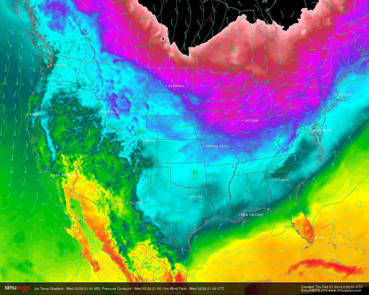
Fresh Arctic Air…A fresh arctic air mass is blowing into the state this morning on gusty northerly winds. Top wind gusts here at IndyWx.com HQ, in southern Boone County, have been clocked at 41 MPH so far this morning.  Despite a lot of sun today, don’t look for the thermometer to move much. In fact, we forecast most communities to remain below the middle teens- a far cry from the average high of the middle 40s.

Watching A Light Snow Maker…Most of Friday will feature sunshine, but clouds will be on the increase during the afternoon and some light snow will follow late Friday night into Saturday morning. This won’t be a big deal and really looks unimpressive- less than an inch for most neighborhoods.

Big Winter Storm Brewing…We continue to gain confidence in a winter storm that will impact central Indiana Saturday night through Monday morning.  The set up is one that will feature an arctic front stalling out across the state Saturday night into early Sunday with moisture overrunning the cold air in place, resulting in periods of significant precipitation- mostly in the form of snow.  Finally, a wave of low pressure will move out of the Mississippi River Valley northeast into the Tennessee Valley Sunday night into early Monday.

Our initial snowfall idea places a band of heavy snow through the majority of central Indiana, including Indianapolis, to the tune of 6-8 inches.

Bitter Air Flows In Behind The Winter Storm…A bitterly cold air mass will plunge into the area behind our winter storm.  With a fresh, deep snow pack in place and clearing skies, it’s possible that we could be looking at below zero temperatures both Tuesday and Wednesday mornings.  Forget that the calendar will say early March by this point…

Upcoming 7-Day Precipitation Forecast

  • 7-Day Snowfall Forecast: 6-9″
  • 7-Day Rainfall Forecast: 0.00″

imagesFor weather updates and more “behind the scenes” data on the go, be sure to Follow Us on Twitter @indywx or become a Friend of IndyWx.com on Facebook!

twic

Permanent link to this article: https://indywx.com/1186/

Word On The Weekend And A Couple Other Items Of Interest.

We continue to monitor the goings on for the weekend closely.  As of now we still think snow is the dominant form of precipitation across central Indiana and likely comes in “waves” of intensity from late Saturday night into Monday morning.  Significant snowfall totals are possible, but it’s still too early to pin point totals due to the chance of some mixing issues (sleet, freezing rain) for some and the overall placement of the cold front.  This will be a bit different than what we’ve experienced with our last couple of winter storms and could be more of a prolonged event as warmer moist air overruns the cold air at the surface.  Again, exactly where the arctic boundary stalls Saturday night into Sunday will determine the precise precipitation types and exactly who sees snow versus sleet and freezing rain.  Stay tuned.

In other news…if you thought it’s been a cold winter then you’d be correct. In fact, this “cool” image from IEM shows that central Indiana has been at 32 degrees, or lower, between 60-70% of the time since December 1st.  Impressive, for sure!

BhaPsoICIAAP9Md

Finally, another arctic cold front will slam into central Indiana tomorrow morning and will be accompanied by howling northerly winds gusting to 40-50 MPH and a potential quick-hitting snow shower.  This will set the stage for a brutal Thursday as temperatures struggle to recover to the lower to middle teens for IND and even colder for the northern ‘burbs.  This is hard to handle when considering we’re expected to “normally” reach the middle 40s this time of year.

simuawips-2

Permanent link to this article: https://indywx.com/word-on-the-weekend-and-a-couple-other-items-of-interest/

Tracking A Late Weekend Winter Storm

Wed. Thr. Fri. Sat. Sun. Mon. Tue.               5/ 18 8/ 14 2/ 23 22/ 37 20/ 30 10/ 20 5/ 18  – –…

You must be logged in to view this content. Click Here to become a member of IndyWX.com for full access.  Already a member of IndyWx.com All-Access?  Log-in here.

Permanent link to this article: https://indywx.com/tracking-a-late-weekend-winter-storm/

Old Man Winter Is Back… (Did He Ever Leave)?

We touch on the potential winter storm brewing in the Sunday-Monday time period in this video.  A significant winter storm is brewing for some and we cover some initial thoughts…

You must be logged in to view this content. Click Here to become a member of IndyWX.com for full access.  Already a member of IndyWx.com All-Access?  Log-in here.

Permanent link to this article: https://indywx.com/old-man-winter-is-back-did-he-ever-leave/