Category: snow

Back To Winter We Go

Fri.

Sat.

Sun.

Mon.

Tue.

Wed.

Thr.

 Status-weather-snow-scattered-day-icon

 Status-weather-clouds-icon

 Status-weather-snow-scattered-day-icon

 Status-weather-snow-scattered-day-icon

 Status-weather-clouds-icon

 Status-weather-clouds-icon

 Status-weather-clouds-icon

31/ 43

31/ 44

26/ 34

18/ 32

19/ 26

8/ 22

7/ 19 

Light

– – –

Light

Light

– – –

– – –

– – –

Forecast Updated 02.21.14 @ 7:30a

Chilly, Windy Close To The Week…After a busy Thursday night that included hail reports, damaging wind gusts, and flooding we’re looking at a calmer, yet blustery and colder close to the work week as low pressure heads north into Canada.  Winds will remain strong and gusty this morning, but begin to “relax” as we head into the afternoon, diminishing slowly through the day.  That said, it’ll remain quite blustery and much cooler than the flirt with spring Thursday.  A couple of snow showers may fly in shallow wrap around moisture this morning.

For now, we think Saturday will remain mostly dry, but a fast moving weather disturbance will scoot by to our north and could result in an increase in cloud cover Saturday afternoon.

Sunday Snow?  That remains the question, but we continue to closely monitor a disturbance that could produce accumulating snow here Sunday afternoon into Monday.  Model data is all over the place and ranges anywhere from a mainly dry day Sunday to a full blown accumulating snow event of a few inches.  It’s worth noting the Canadian is the most bullish on Sunday accumulation potential and we’re leaning more towards that direction as of now, especially when considering the way the Canadian handled the Valentine’s snow event.  Stay tuned.

Big Cold…A major league late season blast of arctic air will blow into town by the middle of next week and result in temperature close to 25-30 degrees below normal.  We’ll monitor the “goings on” late next week as indications points towards a storm brewing.  Early ideas take this mainly south of our immediate region, but we’ll continue to monitor.

Upcoming 7-Day Precipitation Forecast

  • 7-Day Snowfall Forecast:  1-3″
  • 7-Day Rainfall Forecast: 0.00″


images

For weather updates and more “behind the scenes” data on the go, be sure to Follow Us on Twitter @indywx or become a Friend of IndyWx.com on Facebook!

twic

Permanent link to this article: https://indywx.com/2014/02/20/back-to-winter-we-go/

Focus On Mid Week Flood/ Storm Threat…

Wed.

Thr.

Fri.

Sat.

Sun.

 Mon.

Tue.

 Status-weather-clouds-icon

 Status-weather-storm-night-icon

 Status-weather-clouds-icon

 Status-weather-snow-scattered-day-icon

 Status-weather-snow-scattered-day-icon

 Status-weather-clouds-icon

 Status-weather-snow-scattered-icon

35/ 50

36/ 60

29/ 43

29/ 39

21/ 35

17/ 28

16/ 24 

0.00”

0.75″-1.00″

0.00”

Trace

Trace

0.00″

Accumulating snow?

Forecast Updated: 02.19.14 @ 8:00a

One More Calm Day…A weak front blew through early Wednesday and produced a light shower for southeast parts of the state.  Sunshine will return Wednesday along with a blustery northwest wind.  It’ll be another mild day.

Concern For Flooding And Severe…With continued melting of a deep snow pack, combined with around an inch of rain (most of which falls within a 3 hour time period Thursday) and the stage will certainly be set for flooding.  In fact, we remain very concerned for flooding Thursday. If you live in a flood prone area, please prepare to seek higher ground Thursday as flood waters rise.

The second concern is a severe potential Thursday evening.  While the greatest threat for severe weather will remain south and east of our immediate region, we’ll have to be mindful of the potential of damaging straight line wind gusts Thursday evening.  The greatest threat lies between 5PM and 8PM Thursday as a line of thunderstorms pushes east through the state.  Again, damaging straight line winds, in excess of 60 MPH, is our greatest concern at present time.  Stay tuned.  Drier and much colder air will roar in behind the front Thursday night on strong and gusty northwest winds.

Weak Weekend Disturbances…A couple of fast moving disturbances will pass through the region this weekend and could spark scattered snow showers in the much colder air.

Accumulating Snow Early Next Week…Model data continues to struggle in the mid range handling energy coming east before what continues to look like a big blast of arctic air to wrap up February.  As of now, we’re targeting Tuesday for best chances of accumulating snow, but stress this a low confidence forecast in regards to timing at present.  Stay tuned.

images

For weather updates and more “behind the scenes” data on the go, be sure to Follow Us on Twitter @indywx or become a Friend of IndyWx.com on Facebook!

twic

Permanent link to this article: https://indywx.com/2014/02/18/focus-on-mid-week-flood-storm-threat/

Messy Afternoon Commute Ahead

Latest thinking around our wintry mess due in here this afternoon places a heavier emphasis on sleet and freezing rain for central Indiana, with accumulating snow still a possibility, especially north of Indianapolis.

Overnight model data trended warmer (especially aloft) and latest high resolution, short-term, data continues that trend this morning.  While an initial push of moisture has led to snow and sleet reports already this morning, it’s around 1 o’clock when we think the true slug of moisture reaches the city, itself.  While snow can’t completely be ruled out, I’m more concerned with sleet and freezing rain potential for Indianapolis.

Officially, we’re calling for 1″ of snow/ sleet with up to two tenths of freezing rain for the city, itself.  Further north, a band of 1-3″ of snow/ sleet can be expected with only light freezing rain.  From Benton County over to Wells County, we anticipate mostly a snow event with 3-6″ of snow expected.

All of that said, we leave you with this humble disclaimer; this is easily the most difficult forecast we’ve had to make this winter.  Several factors will come into play to ultimately determine the precise precipitation zones, including track and strength of the low, precipitation rates, amount of evaporative cooling, etc.  This is a low confidence forecast when it comes to precipitation types, but our best idea is below for your viewing pleasure.  Needless to say, regardless of what type of precipitation you see this afternoon, prepare for another nasty afternoon and evening commute.  Stay safe.

UPDATED021714

Permanent link to this article: https://indywx.com/2014/02/17/messy-afternoon-commute-ahead/

Early 0z Runs Trending More Icy Vs. Snowy…

Quick post tonight just to alert you that early model runs off the 0z suite of data suggests less of   a snow threat and more of freezing rain/ sleet…

You must be logged in to view this content. Click Here to become a member of IndyWX.com for full access.  Already a member of IndyWx.com All-Access?  Log-in here.

Permanent link to this article: https://indywx.com/2014/02/16/early-0z-runs-trending-more-icy-vs-snowy/

Sunday Afternoon Thoughts…

1.) A scan over the latest data continues to point towards an absolute mess of a Monday afternoon.  Our accumulation ideas remain relatively unchanged from this morning’s update, aside from “beefing” expected snow totals for Indy’s northern ‘burbs by 1″.  Most of this falls from noon to 6pm and will be followed by a dry, cold, and blustery Monday night.  After likely a white-nuckle evening commute Monday, the combination of sub-freezing temperatures and gusty northwest winds Monday night will likely lead to another rough commute for Tuesday morning.

** We caution that this will be another “now cast” situation when it comes to precipitation types and their respected precise zones tomorrow afternoon.  Stay tuned here or to your favorite local weather media for updates and potential changes.**

  • Indianapolis northern ‘burbs, including Zionsville: 2-4″ snow and sleet with less than 0.10 of freezing rain.
  • Indianapolis proper: 2″ snow and sleet with around 0.10 of freezing rain
  • Indianapolis southern ‘burbs, including Greenwood: 1″ snow and sleet with up to 0.25 freezing rain.

Snow:IceForecast021714

2.) We continue to monitor what will be a brief thaw and associated flood risk mid week.  Even without rain, water rise would occur and urban flooding from the combination of melting snow and blocked (from all of the snow) drainage zones.  When you add 0.50-1″ of rain atop the melting then problems could arise Wednesday into Thursday.  Additionally, we’ll need to prepare for the likelihood of dense fog Wednesday as milder air surges north over a deep snow pack.

3.) For anyone thinking spring is setting in during our mid week thaw will need to think again. Latest model data continues to suggest we reverse things quickly later this week and for the upcoming weekend.  In fact, some model data, including the European, suggests central Indiana is under the gun for a weekend winter storm.  We’ll continue to monitor closely…

021614ECSatWinterStorm022214

4.)  Additionally, prospects continue to grow for another extended period of well below normal cold and renewed wintry precipitation chances in the long term (into March).  Both the GFS and European models are in agreement on the mid to long range pattern with a trough settling back into the eastern half of the country.

02161412zGFSEC

Permanent link to this article: https://indywx.com/2014/02/16/sunday-afternoon-thoughts/

Cold Today; Messy Monday Ahead.

Sun.

Mon.

Tue.

Wed.

Thr.

Fri.

Sat.

 Status-weather-clouds-icon

 Status-weather-freezing-rain-icon

 Status-weather-clouds-icon

 images

 Status-weather-storm-night-icon

 Status-weather-clouds-icon

 images

16/ 25

15/ 33

20/ 39

24/ 42

35/ 57

28/ 45

28/ 50 

0.00”

1-3″ (and ice)

0.00”

Trace

0.50″-1.00″

0.00″

0.00”

Forecast Updated 02.16.14 @ 11:15a

Cold Sunday…Fresh off celebrating our snowiest winter on record (surpassed last night at IND at 51.6″ and the Record Event Report can be found here), we’ll enjoy a dry day, but blowing and drifting snow will remain an issue in the open country. A few breaks in the cloud cover can be expected this afternoon on what will otherwise be a rather cloudy day.  Highs will only climb into the lower to middle 20s (well below the average high of 40 and closer to the normal low of 24).  Yes, our cold, snowy winter just keeps on keepin’ on!

Snow And Ice Issues Monday…A storm system will move through the region Monday and deliver a mixture of precipitation types across central Indiana.  The way we see things unfolding as of this forecast update brings a wintry mix of sleet and snow into the city around noon with periods of moderate to even heavy wintry precipitation falling into the mid to late afternoon hours before we begin to see the shield of moisture push northeast.  This will be a “thump and go” type event.

As for precipitation type, this remains a challenge and will require much fine tuning later tonight and through the day tomorrow (another now cast scenario).  We’re thinking mostly snow is the dominant form of precipitation from the northern suburbs of Indianapolis and points north.  Here, 2-3″ of wet snow is possible, polished off with a light glaze of a freezing rain/sleet mixture before precipitation ends.  For the city, itself, we think around 1-2″ of snow is possible with a glaze of freezing rain of around a tenth of an inch. Farther south, to include the southern Indianapolis suburbs, an icy mixture of sleet and freezing rain will be the concern with glaze potential approaching one quarter inch.  Again, we caution this is our best idea at this point and we’ll post some fresh thoughts later this evening.

Needless to say, tomorrow stands to include treacherous driving conditions in and around central Indiana and the National Weather Service will likely issue Winter Weather/ Freezing Rain Advisories later this afternoon to account for the wintry conditions anticipated tomorrow afternoon.

Flooding Concerns On The Rise…With such a deep snowpack across central Indiana, combined with a frozen ground, flooding concerns will be on the rise as early as the middle to latter part of the week.  We think dry and chilly (albeit milder) conditions will be with us Tuesday, but low clouds, fog, and drizzle likely develop by Wednesday as milder air streams north over the snowpack locked in across the region.

By Thursday, our attention turns to the potential of heavy rain and a couple of thunderstorms as a cold front blows through the region.  Early ideas of Thursday rainfall numbers would suggest anywhere from .50-1″ of rain is laid down and when combined with the heavy snow pack and milder air, flooding concerns will certainly be present.  Needless to say, if you live in a flood prone area, please monitor the situation closely later this week.

Winter Blows Back In…As promised, the briefly milder shot of air would be just that- brief.  We continue to monitor data that suggests a colder, more wintry, pattern blows right back into the region to wrap up February.

twic

For weather updates and more “behind the scenes” data on the go, be sure to Follow Us on Twitter @indywx or become a Friend of IndyWx.com on Facebook!

images

Permanent link to this article: https://indywx.com/2014/02/16/cold-today-messy-monday-ahead/

Saturday Morning Notes…

* Your full, updated, 7-Day Forecast will be published later tonight. 1.) In the long range, credit the Canadian model for being spot on with yesterday’s snow storm.  It was…

You must be logged in to view this content. Click Here to become a member of IndyWX.com for full access.  Already a member of IndyWx.com All-Access?  Log-in here.

Permanent link to this article: https://indywx.com/2014/02/15/saturday-morning-notes/

Valentine’s Day Snow

Fri.

Sat.

Sun.

Mon.

Tue.

Wed.

Thr.

 Status-weather-snow-scattered-day-icon

 Status-weather-snow-scattered-day-icon

 Status-weather-clouds-icon

 Status-weather-showers-scattered-icon

 Status-weather-clouds-icon

 Status-weather-clouds-icon

 Status-weather-storm-night-icon

19/ 27

6/ 26

14/ 30

23/ 40

22/ 43

32/ 50

38/ 62 

2-5″

1″

0.00”

0.40″

0.00″

0.00″

0.50″

Forecast Updated 02.14.14 @ 11:00a

Accumulating Valentine’s Day Snow…The Canadian led the charge and other modeling has followed suit.  The region will deal with accumulating snow Valentines Day as low pressure moves southeast out of Missouri into the Tennessee Valley.  We think snow will fall at a good clip, periodically heavy, and begin around mid morning around the city.  In fact, a strip of 2-5″ of snow is likely to be laid down between Indianapolis and Louisville later today.  Latest radar trends from upstream and banding features suggest snowfall amounts may reach 6″ along the I-70 corridor. Needless to say, if you have travel plans this afternoon plan for snow covered roads and slick travel.

A fresh shot of arctic air will drill south into the region tonight and result in Saturday “wake up” temperatures in the single digits with a biting northwest wind.

Another Fast Moving Clipper…After a mostly dry Saturday, we forecast light snow to build back into the region Saturday night into early Sunday.  This will only be a light snow event and most amounts will be in the dusting to 1″ category.  The sun should quickly return Sunday afternoon, though it’ll remain colder than normal.

Foggy Start To The Week…As a southerly air flow transports milder air north and over the snow pack across central Indiana fog will develop.  It’s possible some freezing drizzle is dealt with Monday morning before temperatures rise above freezing.  Prepare for a downright gloomy start to the work week.  A cold front will push through the region Monday evening and lead to a period of showers, potentially transitioning to light snow or a light wintry mix Monday night as cold air sweeps back in.

A Spring Tease…A spring tease will have many Hoosiers wanting to break out the shorts by the mid week period.  In fact, highs will zoom into the 60s Thursday, courtesy of a strong and gusty southwest breeze.  The downside?  A line of showers and gusty thunderstorms later in the day.  While we still have a week to monitor this situation, the possibility is there for a few storms to reach severe levels across the Ohio Valley region.  Stay tuned as we monitor this developing weather situation.

Looking longer term, we anticipate the briefly milder spring “tease” to be just that.  Signals are increasingly favorable for a prolonged period of cold, wintry conditions building back into the region as we put a wrap on February and head into March.

imagesFor weather updates and more “behind the scenes” data on the go, be sure to Follow Us on Twitter @indywx or become a Friend of IndyWx.com on Facebook!

twic

Permanent link to this article: https://indywx.com/2014/02/13/valentines-day-snow/

Snowy Friday On Tap (For Some)…

This will be quick this morning, due to time, but we’ll have your complete 7-Day forecast posted tonight. We’re continuing to monitor the weather situation Friday.  The Canadian has led…

You must be logged in to view this content. Click Here to become a member of IndyWX.com for full access.  Already a member of IndyWx.com All-Access?  Log-in here.

Permanent link to this article: https://indywx.com/2014/02/13/snowy-friday-on-tap-for-some/

Next Week’s Spring Tease Is Just That, A “Tease…”

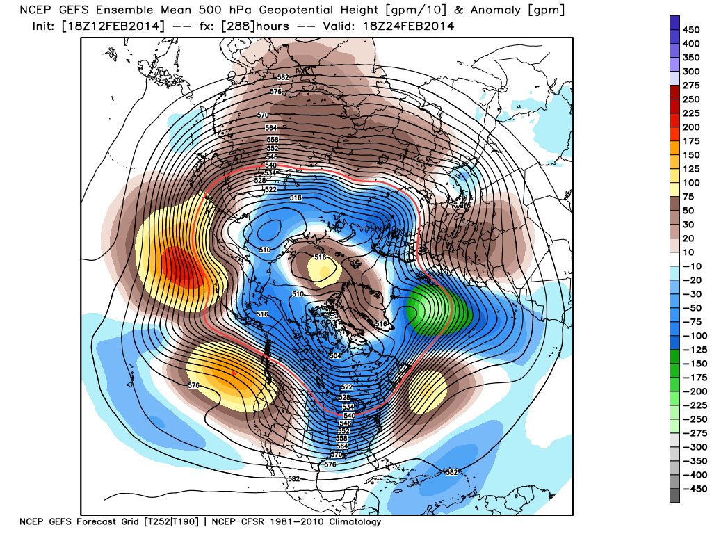
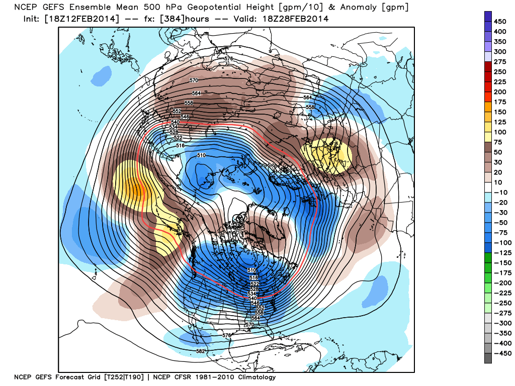
There’s no doubt we’re looking at a brief pattern change next week that will result in air temperatures that will have many of you craving spring.  That said, the key word in that sentence is “brief” and a colder, more wintry pattern looks to return to wrap up February and head into March.

Before we discuss the return of the cold and potentially wintry regime for late month, let’s focus on the milder conditions.  Data suggests we may be looking at highs zooming all the way into the lower to middle 60s towards the 20th-23rd time period.  The spring tease is likely to come at a cost as the milder southerly breezes likely result in lots of dense fog and areas of drizzle as a deep snowpack remains locked in place.  Flooding concerns may also become a concern next week, especially if we inject moderate to heavy rain into the region.  10-day rainfall numbers do have to make us a little nervous as a blend of model data suggests 1″-1.5″ down between now and the 22nd.  We’ll continue to monitor things.

Finally, it should be noted that while a brief “relaxation” of the seemingly unending winter is on the way, the long term pattern continues to suggest a cold and wintry time of things continues overall.  Next week appears to be an “island of warmth in a sea of cold” type pattern.  Latest ensemble data continues to back this idea up.  That’s not saying we’re going to deal with the type of severe cold we’ve seen over the past several weeks, but instead means we’re going to go back below normal as we get set to wrap up February and head into March.

The latest GFS ensembles show the evolution of things well.  The “double secret probation” European model also shows something similar.

gefs_z500anom_nh_33gefs_z500anom_nh_49gefs_z500anom_nh_65

Note the ridge and associated spring “tease” is replaced with a cold and more wintry looking eastern trough rather quickly.  Circle the 24th on your calendar for the potential of a widespread storm system.  Far too early for details or questions, but the pattern looks to produce some busy times around this point.  Before that we have plenty of weather in front of us to deal with… weekend snow opportunities, foggy/ drizzly weather to accompany the initial surge of milder air next week, and a spring tease by late next week!

Permanent link to this article: https://indywx.com/2014/02/12/next-weeks-spring-tease-is-just-that-a-tease/

IndyWx.com