Category: snow

Accumulating Ice And Snow Then Frigid

Sun.

Mon.

Tue.

Wed.

Thr.

Fri.

Sat.

 Status-weather-snow-scattered-icon

 Status-weather-clouds-icon

 Status-weather-clouds-icon

 Status-weather-clouds-icon

 Status-weather-clouds-icon

 Status-weather-showers-day-icon

 Status-weather-snow-scattered-day-icon

16/ 23

9/ 19

4/ 28

10/ 30

18/ 38

27/ 50

22/ 37 

Moderate

– – –

– – –

– – –

– – –

Light

Light

Forecast Updated: 03.02.14 @ 12:25a

Sunday Winter Storm…The well advertised winter storm is here and will make a mess of travel and plans for the second half of your weekend.  Moisture is streaming northeast over a bitterly cold air mass locked in place at the surface and this will create a mixture of sleet and freezing rain to quickly change to a mixture of sleet and snow during the early morning hours across central Indiana.

We forecast precipitation intensity to really begin to increase across the greater central Indiana region around 3-4 am.  Waves of accumulating snow will continue through the day, though it won’t snow all day.  In particular, we bracket 4am to 10am and then again early Sunday afternoon.

Finally, a wave of low pressure will eject into the Tennessee Valley Sunday night into Monday, continuing the significant snow and icing down state.  We anticipate the majority, if not all, of “round two” to bypass most of central Indiana to the south Sunday evening into early Monday.  So, what’s the culprit behind the suppression?  As mentioned in previous posts, a powerful arctic high will build south Sunday into Sunday night and this is the primary driver for the shift south in the surface low track.

All of that said, we’re still looking at significant accumulations of sleet and snow across central Indiana today, though reduced from the 6-8″ forecast we’ve had out since Thursday morning.  We now forecast 2-5″ of snow and sleet across central Indiana.  Needless to say, we’ll continue to monitor.  Sunday night will turn downright frigid across the region as temperatures crash into the upper single digits.

As a quick side note, we once again have to tip our cap to the Canadian forecast model.  It began to catch onto the southward shift with “phase 2” of the storm well in advance of the other model data (during the mid week period), including the highly touted European forecast model.

Frigid Start To The Work Week With Slow Mid Week Moderation…Fresh arctic air will be locked in place across the area to begin the new work week.  While it’ll be dry, temperatures will run as much as 30 degrees below seasonal norms.  The cold winter of 2013-2014 just doesn’t want to let up.

As we push into the mid week stretch we’ll note a powerful Gulf low that’s expected to push up the eastern seaboard. Early indications here keep us dry with slowly moderating temperatures.  Though we’ll remain well below normal, it’ll be a step in the right direction, so to speak, from the frigid early week start.

Weak Late Week System…The early take on late next week shows a cold front moving through Friday afternoon and evening. This may create a few rain showers Friday evening followed by light snow Friday night into Saturday morning as a fresh push of cold air blows into the state.  We have time to watch this and update as needed.

Upcoming 7-Day Precipitation Forecast

  • 7-Day Snowfall Forecast: 2-5″
  • 7-Day Rainfall Forecast: 0.25″

We’ll have fresh thoughts posted here and on our social media accounts through the day.  Have a nice Sunday and God Bless!  You can follow us on Twitter @indywx and become a friend of ours on Facebook by searching IndyWx.com.

Permanent link to this article: https://indywx.com/2014/03/02/accumulating-ice-and-snow-then-frigid/

Some Late Night Thoughts…

It’s been a long day, but we’d like nothing more than to be right here in the good ole forecast office, digging into data for our next winter storm with you.  While “part 2” of the storm remains just offshore as of this post, it’ll likely be trudging onshore by the time you read this early Saturday morning.  That said, the initial wave of accumulating snow (and for some, ice) will arrive as early as late Saturday night/ wee morning hours (well before sunrise) Sunday in the form of an overrunning event- where comparably warmer, more moist air is lifted up and overruns the cold air at the surface.

Early ideas suggest we undergo a period of moderate to heavy wintry precipitation as early as 3-ish Sunday morning, extending into the late morning hours.  Particularly, we bracket the hours of 3am to 10am Sunday for the initial wave of wintry weather.  This will be a mixed bag of precipitation, including snow, sleet, and freezing rain across central Indiana.  An early look at the high resolution simulated radar courtesy of the NAM shows this well- valid 7am Sunday morning.  Image is courtesy of the fine folks over at Weatherbell Analytics.

hires_ref_indy_37

After a “lull” in the accumulating wintry precipitation from late morning/ early afternoon Sunday, we’ll likely deal with another round of moderate to heavy accumulating wintry precipitation Sunday afternoon into Sunday night.  It’s important to note this is where we have more questions than answers in regards to the interaction of a juiced up southern stream of the jet- infused by the powerhouse late season winter storm (still spinning just off shore as of this update).  Powerful arctic high pressure will be sinking south and could result in a more suppressed track of the low. Should this be the correct scenario snow totals would likely be towards the lower end of the ongoing 6-8″ forecast we hoisted back on Thursday morning.  That said, one can’t ignore the pattern as it’s one notorious for heavy snow producers across central Indiana.  A scan over heavy snow events of the past here across central Indiana show similar setups that have yielded impressive snow totals.  Just as the potential of suppression has to be noted, so should the potential of a slightly more north trend that models may currently see as time gets closer.

In closing tonight, 12z model data should really begin to hone in on the area most likely to see heaviest snow and/ or ice accumulations.  Our ongoing forecast of storm totals remains unchanged for now of 6-8″.  Stay tuned, friends.

Permanent link to this article: https://indywx.com/2014/02/28/some-late-night-thoughts/

More On This Weekend’s Winter Storm…

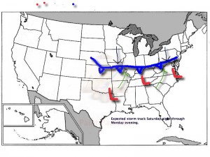
As we’ve been discussing, a significant winter storm is developing this weekend.  The set up is one that will feature an arctic cold front sinking south and stalling out across southern and central Indiana Saturday night.  Low pressure will then organize over the Ark-la-tex region and head northeast, tracking into the northern Tennessee Valley Sunday and Sunday night.  The low will move off the southern Mid Atlantic coastline Monday evening.  This will be more of a prolonged event when compared to our last two winter storms as waves of moderate to heavy snow move into central Indiana beginning late Saturday night.

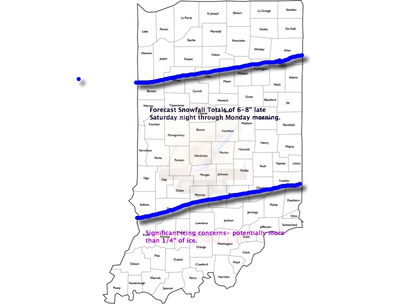
This is an ominous set up for more heavy snow across central Indiana- one that’s notorious for heavy snow events across central Indiana.  We hoisted our initial snowfall forecast Thursday morning and placed central Indiana under the threat for 6-8″.  As of this morning, we’re remaining firm on that idea.  It should be noted that the GFS remains very bullish on heavier totals (and consistent, as well), but it should also be pointed out it’s somewhat of an outlier as of this morning as the GEM and ECMWF are more suppressed with lighter totals.  All of that said, we lean more towards the GFS solution versus the more suppressed Canadian and, to some extent, European forecast model.  Should the other model data begin to trend towards the snowfall idea per the GFS then the initial 6-8″ forecast will have to be adjusted upward.  The storm is just now coming onshore and will be sampled better with model runs later today.

Any way you slice it, a significant and disruptive winter storm is brewing this weekend and could make an absolute mess of your Sunday and Monday.  A shot of bitterly cold air will flow in behind our departing storm early next week.

Our current accumulation idea and storm track can be found below:  We’ll have another update here late tonight and you can keep up-to-date with all of our thoughts on the go on Twitter (@indywx).

WinterStormTrack030214


WinterStorm030214Totals1

Permanent link to this article: https://indywx.com/2014/02/28/more-on-this-weekends-winter-storm/

Winter Storm Watch Hoisted

URGENT - WINTER WEATHER MESSAGE NATIONAL WEATHER SERVICE INDIANAPOLIS IN 405 AM EST FRI FEB 28 2014 ...WINTER STORM TO AFFECT CENTRAL INDIANA... .A WINTER STORM IS PROGGED TO MOVE…

You must be logged in to view this content. Click Here to become a member of IndyWX.com for full access.  Already a member of IndyWx.com All-Access?  Log-in here.

Permanent link to this article: https://indywx.com/2014/02/28/winter-storm-watch-hoisted/

Arctic Blast Today; Big Winter Storm Brewing

Thr.

Fri.

Sat.

Sun.

Mon.

Tue.

Wed.

 Status-weather-clouds-icon

 Status-weather-snow-scattered-day-icon

 Status-weather-snow-scattered-day-icon

 Status-weather-snow-scattered-icon

 Status-weather-snow-scattered-day-icon

 Status-weather-clouds-icon

 Status-weather-clouds-icon

6/ 14

10/ 35

2839

19/ 30

10/ 19

– 5/ 19

0/ 20 

– – –

Light

Light

Heavy

Light

– – –

– – –

Forecast Updated 02.27.14 @ 7:30a

Fresh Arctic Air…A fresh arctic air mass is blowing into the state this morning on gusty northerly winds. Top wind gusts here at IndyWx.com HQ, in southern Boone County, have been clocked at 41 MPH so far this morning.  Despite a lot of sun today, don’t look for the thermometer to move much. In fact, we forecast most communities to remain below the middle teens- a far cry from the average high of the middle 40s.

Watching A Light Snow Maker…Most of Friday will feature sunshine, but clouds will be on the increase during the afternoon and some light snow will follow late Friday night into Saturday morning. This won’t be a big deal and really looks unimpressive- less than an inch for most neighborhoods.

Big Winter Storm Brewing…We continue to gain confidence in a winter storm that will impact central Indiana Saturday night through Monday morning.  The set up is one that will feature an arctic front stalling out across the state Saturday night into early Sunday with moisture overrunning the cold air in place, resulting in periods of significant precipitation- mostly in the form of snow.  Finally, a wave of low pressure will move out of the Mississippi River Valley northeast into the Tennessee Valley Sunday night into early Monday.

Our initial snowfall idea places a band of heavy snow through the majority of central Indiana, including Indianapolis, to the tune of 6-8 inches.

Bitter Air Flows In Behind The Winter Storm…A bitterly cold air mass will plunge into the area behind our winter storm.  With a fresh, deep snow pack in place and clearing skies, it’s possible that we could be looking at below zero temperatures both Tuesday and Wednesday mornings.  Forget that the calendar will say early March by this point…

Upcoming 7-Day Precipitation Forecast

  • 7-Day Snowfall Forecast: 6-9″
  • 7-Day Rainfall Forecast: 0.00″

imagesFor weather updates and more “behind the scenes” data on the go, be sure to Follow Us on Twitter @indywx or become a Friend of IndyWx.com on Facebook!

twic

Permanent link to this article: https://indywx.com/2014/02/27/1186/

Word On The Weekend And A Couple Other Items Of Interest.

We continue to monitor the goings on for the weekend closely.  As of now we still think snow is the dominant form of precipitation across central Indiana and likely comes in “waves” of intensity from late Saturday night into Monday morning.  Significant snowfall totals are possible, but it’s still too early to pin point totals due to the chance of some mixing issues (sleet, freezing rain) for some and the overall placement of the cold front.  This will be a bit different than what we’ve experienced with our last couple of winter storms and could be more of a prolonged event as warmer moist air overruns the cold air at the surface.  Again, exactly where the arctic boundary stalls Saturday night into Sunday will determine the precise precipitation types and exactly who sees snow versus sleet and freezing rain.  Stay tuned.

In other news…if you thought it’s been a cold winter then you’d be correct. In fact, this “cool” image from IEM shows that central Indiana has been at 32 degrees, or lower, between 60-70% of the time since December 1st.  Impressive, for sure!

BhaPsoICIAAP9Md

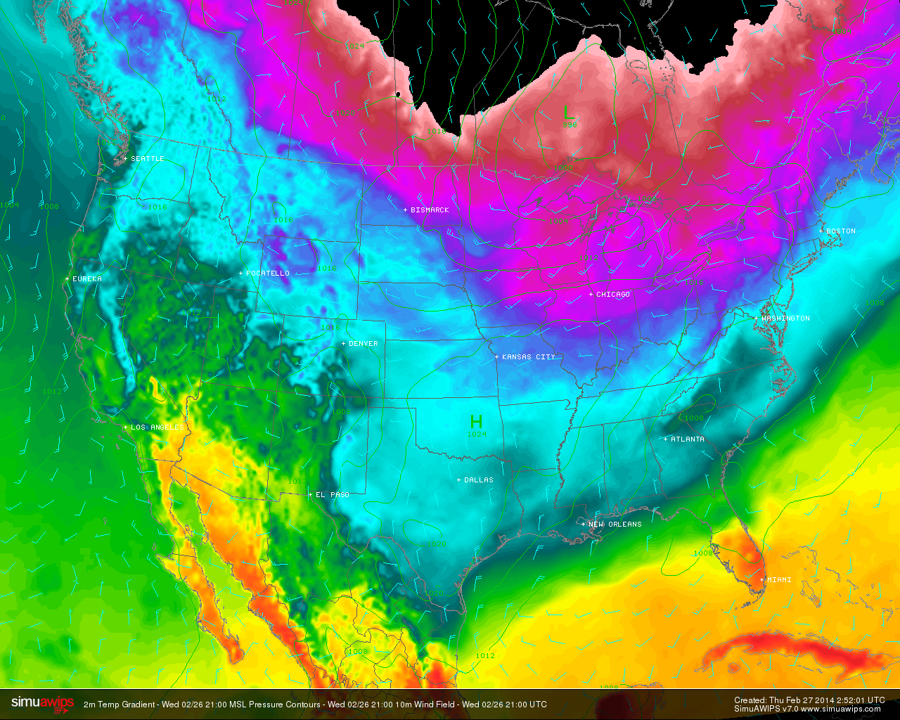
Finally, another arctic cold front will slam into central Indiana tomorrow morning and will be accompanied by howling northerly winds gusting to 40-50 MPH and a potential quick-hitting snow shower.  This will set the stage for a brutal Thursday as temperatures struggle to recover to the lower to middle teens for IND and even colder for the northern ‘burbs.  This is hard to handle when considering we’re expected to “normally” reach the middle 40s this time of year.

simuawips-2

Permanent link to this article: https://indywx.com/2014/02/26/word-on-the-weekend-and-a-couple-other-items-of-interest/

Tracking A Late Weekend Winter Storm

Wed. Thr. Fri. Sat. Sun. Mon. Tue.               5/ 18 8/ 14 2/ 23 22/ 37 20/ 30 10/ 20 5/ 18  – –…

You must be logged in to view this content. Click Here to become a member of IndyWX.com for full access.  Already a member of IndyWx.com All-Access?  Log-in here.

Permanent link to this article: https://indywx.com/2014/02/25/tracking-a-late-weekend-winter-storm/

Old Man Winter Is Back… (Did He Ever Leave)?

We touch on the potential winter storm brewing in the Sunday-Monday time period in this video.  A significant winter storm is brewing for some and we cover some initial thoughts…

You must be logged in to view this content. Click Here to become a member of IndyWX.com for full access.  Already a member of IndyWx.com All-Access?  Log-in here.

Permanent link to this article: https://indywx.com/2014/02/24/old-man-winter-is-back-did-he-ever-leave/

Feeling More Like The Heart Of Winter

Mon. Tue. Wed. Thr. Fri. Sat. Sun.               16/ 29 21/ 29 2/ 19 18/ 29 13/ 27 13/ 20 10/ 22  Light Light…

You must be logged in to view this content. Click Here to become a member of IndyWX.com for full access.  Already a member of IndyWx.com All-Access?  Log-in here.

Permanent link to this article: https://indywx.com/2014/02/23/feeling-more-like-the-heart-of-winter/

Light Accumulating Snow Targets Areas Just North Of Indianapolis

Latest high resolution data overnight suggests we focus our attention from Indianapolis and points north for tonight’s light snow event.  Before that, be sure to get out today and enjoy the sunshine and one last day of relative warmth as highs zoom close to 50 for many throughout central Indiana on a gusty southwest wind this afternoon.

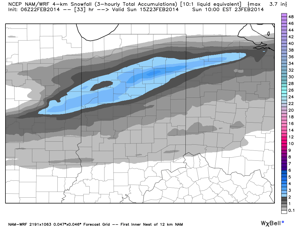
Light rain moves in this evening- initially around 6-7 for north-central Indiana, but may not reach the city, itself, until mid to late evening (more like 8 to 9 o’clock).  Rain will then mix with and change to snow (from north to south) during the overnight.  Our official accumulation idea looks very much like the latest high resolution NAM model.

hires_snow_acc_indy_11

Specific snowfall forecasts from a few select locations for tonight into early Sunday:

  • Indianapolis: 0.50-1″
  • Northern ‘burbs (Zionsville, Carmel, Westfield): 1″-1.5″
  • Lafayette: 2-3″

In other words, this isn’t anticipated to be a huge snow event by any means.  That said, we’ll keep a close eye on things as we fine tune the timing between the arrival of the cold air and departure of precipitation tonight.  We’ll fine tune later this evening if needed.

Enjoy your Saturday!

Permanent link to this article: https://indywx.com/2014/02/22/light-accumulating-snow-targets-areas-just-north-of-indianapolis/

IndyWx.com