Category: Sleet

Arctic Air Inbound…

screen-shot-2016-12-05-at-11-19-01-pmHighlights:

  • Morning showers
  • Snow showers late tomorrow night
  • Arctic air arrives
  • Weekend storm system

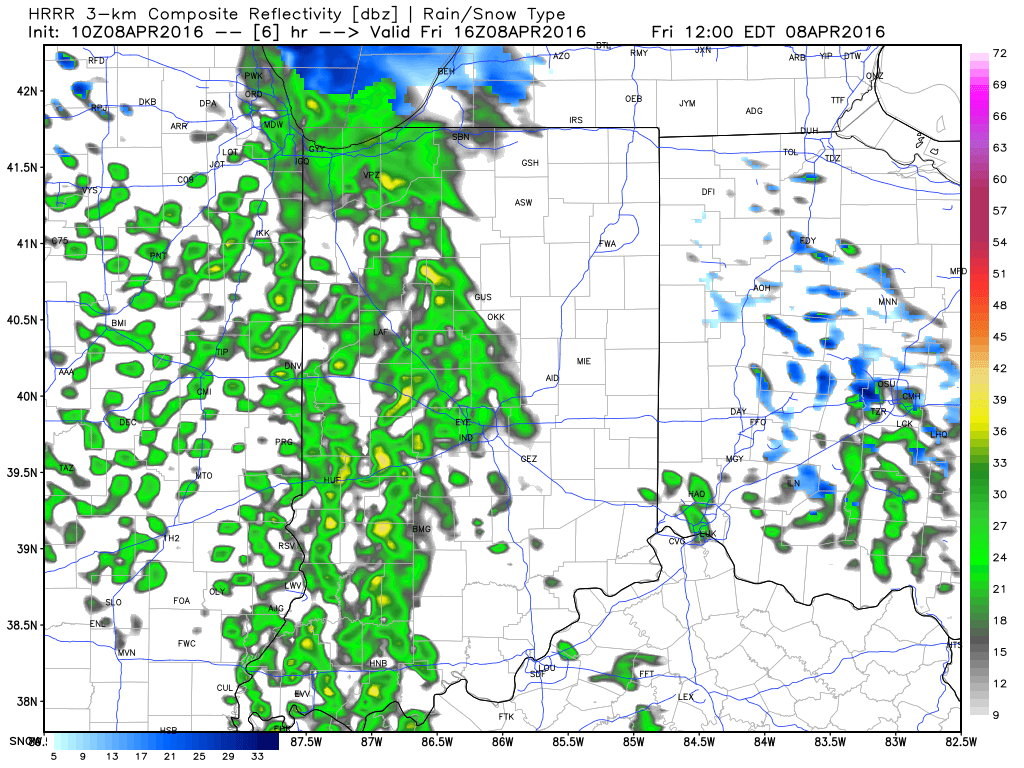
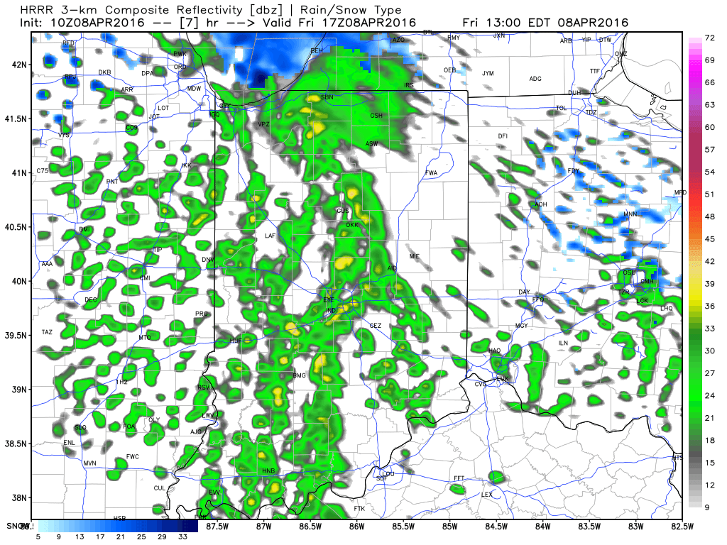
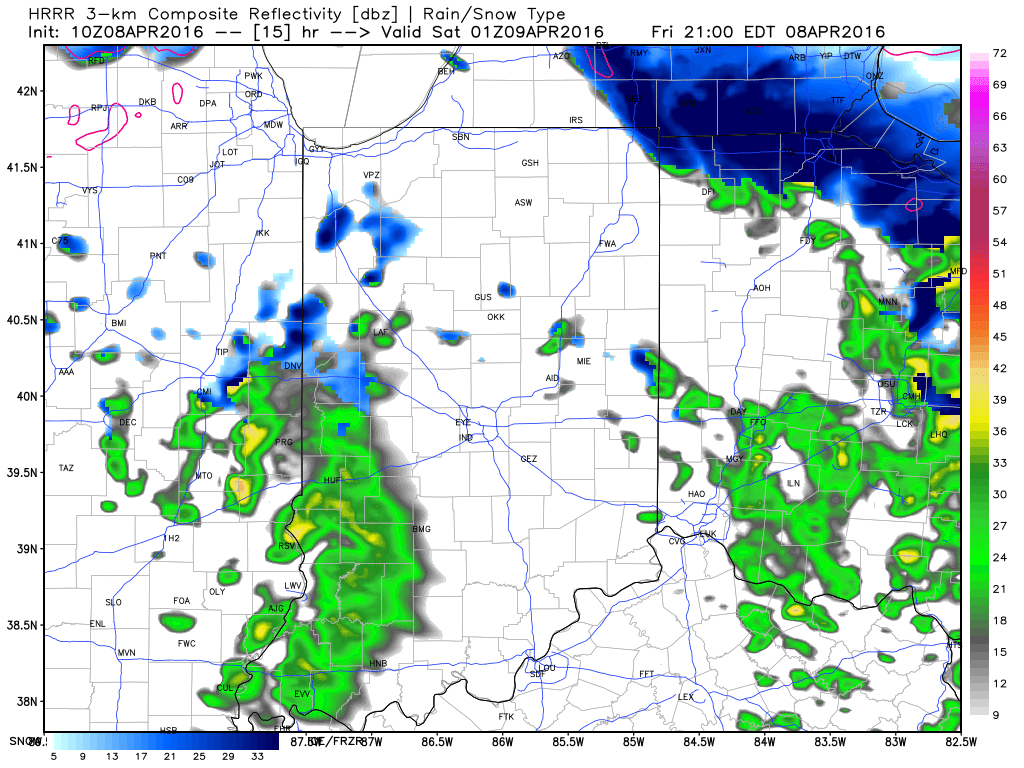
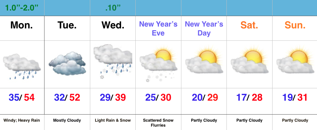
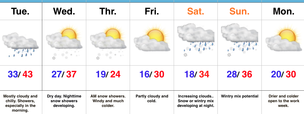
Find That Heavier Winter Gear…Our next area of low pressure will push northeast between now (north-central Gulf Coast) and Tuesday night (central Appalachians).  Most of the widespread rain will fall across southeast IN this go around, but enough moisture will spread west to result in scattered to numerous showers Tuesday morning.  With temperatures in the lower to middle 30s, don’t be surprised if a sleet pellet or snow flake mix in at times.  All in all, expect another “raw” day.  Drier times will await for the evening rush home.

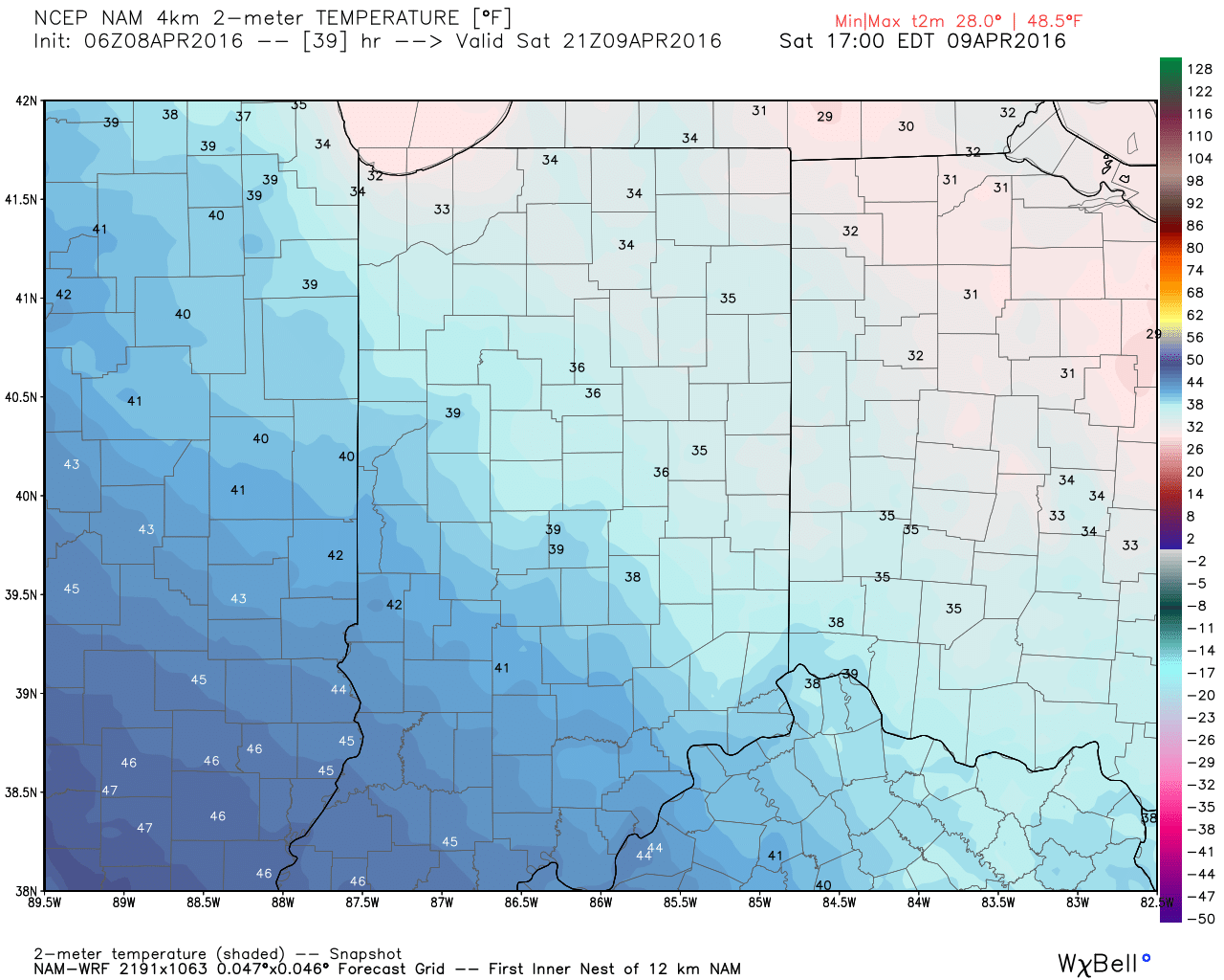
Wednesday will feature mostly dry conditions, but the arctic hounds will be howling to our northwest.  Snow showers will precede this arctic blast Wednesday night and Thursday morning and may be enough to accumulate for some.  While models remain drier than we’d expect (given the overall set-up), we may “eek” out just enough moisture to coat the ground up for some. Thursday will be a frigid day, including wind chills in the single digits.  Heavier winter gear will be required to wrap up the work week.

The weekend features more “fun and games” as an area of low pressure attacks stale cold air left over from the late week arctic push.  Is the cold air deep enough to create wintry problems or does the southerly flow help scour out the chill and lead to more of a liquid event.  Stay tuned.

Upcoming 7-Day Precipitation Forecast:

  • Snowfall: 1″ – 3″
  • Rainfall: 0.50″

Permanent link to this article: https://indywx.com/arctic-air-inbound/

VIDEO: Thanksgiving Weather; “Interesting” Open To December…

You must be logged in to view this content. Click Here to become a member of IndyWX.com for full access.  Already a member of IndyWx.com All-Access?  Log-in here.

Permanent link to this article: https://indywx.com/video-thanksgiving-weather-interesting-open-to-december/

Thundersleet and Thundersnow Possible Later Today…

While the morning is off to a frigid and quiet start, changes will begin to take place as early as late morning into the early afternoon hours.  Another disturbance will rotate through central IN this afternoon and evening and interact with the unseasonably cold air (both aloft and at the surface) to ignite convective showers.  Some of these showers, mixed at times with sleet and snow, will be accompanied by thunder.

1

2Eventually, as cold air is reinforced this evening, all precipitation should transition to snow this evening into early Saturday.  While it won’t snow for everyone, scattered heavy snow bursts will be plenty capable of producing a quick coating for some neighborhoods tonight.

3Speaking of the cold, highs Saturday will remain in the 30s for most.  Yes, this is April…

4Hang in there, friends.  After another chilly week next week, changes are in the offing for late month.  Warmth is coming….eventually.  🙂

Permanent link to this article: https://indywx.com/thundersleet-and-thundersnow-possible-later-today/

Rain Transitioning To Snow…

Rain is beginning to transition to sleet and snow across central IN, and we expect the transition to push into Indianapolis proper around 4p.  As for accumulations, we have no…

You must be logged in to view this content. Click Here to become a member of IndyWX.com for full access.  Already a member of IndyWx.com All-Access?  Log-in here.

Permanent link to this article: https://indywx.com/rain-transitioning-to-snow/

Strong Winds; More Heavy Rain…

Screen Shot 2015-12-28 at 7.38.21 AMHighlights:

  • Strong winds and flood threat continues
  • Weak mid week system
  • Much colder to open the New Year

Strong Winds And Flood Threat Remains…What an active morning across central IN!  Northeast winds are already gusting around 40 MPH with periods of heavy rain this morning.  Across our northern tier of counties (mainly north of a line from LAF to KOK) freezing rain and sleet is the issue this morning with temperatures below freezing.

Periods of heavy rain will continue today, and we also note the threat of embedded thunder (damaging wind risk) this evening, bracketed between the hours of 6p-8p.

Image below is courtesy of Weatherbell.com

StrongWindsTemperatures will remain cold and raw through most of the day before we see a late day rally briefly into the lower to middle 50s.  It’ll be another day with a tight temperature gradient across the state, as northern IN will struggle to make it much above freezing, while southern IN approaches the upper 60s this evening.

Midnight highs Tuesday can be expected before temperatures crash.

We’ll then set our eyes towards a weak wave of low pressure that looks to deliver a light mixed bag of precipitation Wednesday morning.  The freezing line will run through the central part of IN and a mixture of light snow and light rain can be expected.  MUCH colder air flows into the state behind this system and sets the stage for a cold open to 2016.

Image below is courtesy of Weatherbell.com

WednesdayForecast models continue to show an expected pattern shift to all-out sustained cold and wintry conditions for mid and late winter.  Note the W NA ridging developing.  Additionally, blocking and a negative AO develop as mid January nears.  Think this is the year without a winter?  Better think again, my friends.

Image below is courtesy of Tropicaltidbits.com

MidJan2016

Permanent link to this article: https://indywx.com/strong-winds-more-heavy-rain/