
You must be logged in to view this content. Click Here to become a member of IndyWX.com for full access. Already a member of IndyWx.com All-Access? Log-in here.
Category: Severe Weather
Permanent link to this article: https://indywx.com/2019/05/05/all-access-video-week-ahead-outlook-cooler-than-average-pattern-on-deck-as-may-progresses/
May 04
#AGwx And Weekly Severe Weather Outlook…
Forecast Period: 05.05.19 through 05.12.19
7-Day Precipitation: Rainfall is expected to run above average through the period.

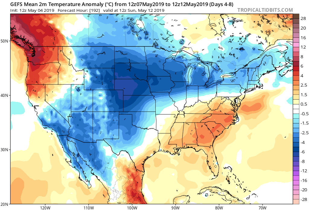
7-Day Temperatures: Above average temperatures are expected through the early portion of the period before things trend cooler than average by late week into next weekend.
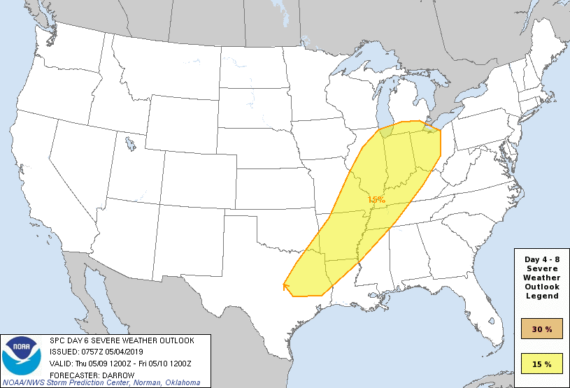
Severe Weather: While a major, widespread severe weather outbreak isn’t expected, we’ll have to keep close eyes on Wednesday evening into Thursday as a surface low tracks into the Great Lakes and drags an associated cold front into a warm and rather muggy air mass in place. Though still several days out, the potential is present for a few strong to severe storms, including large hail and damaging wind threats.
Summary: Another active week is ahead, including a couple rounds of more widespread shower and thunderstorm activity. Most concentrated storm activity should come Wednesday evening into Thursday and feature the potential of locally heavy rainfall. Widespread rainfall this week should total 1″ to 1.5″ with locally heavier totals. The bulk of this rain will fall Wednesday into Thursday. Looking further ahead, the good news here is that high pressure looks to build in as we get set to wrap up the work week and head into next weekend, helping to supply a period of dry weather Friday and throughout the weekend. (Fingers are crossed).
Permanent link to this article: https://indywx.com/2019/05/04/agwx-and-weekly-severe-weather-outlook-2/
May 04
All-Access Video: Sunshine Returns Sunday; Another Busy Week Ahead…
You must be logged in to view this content. Click Here to become a member of IndyWX.com for full access. Already a member of IndyWx.com All-Access? Log-in here.
Permanent link to this article: https://indywx.com/2019/05/04/all-access-video-sunshine-returns-sunday-another-busy-week-ahead/
May 02
All-Access Morning Video: Timing Out Rain Coverage Into The Weekend; Looking Ahead To A Continued Wet Pattern…
You must be logged in to view this content. Click Here to become a member of IndyWX.com for full access. Already a member of IndyWx.com All-Access? Log-in here.
Permanent link to this article: https://indywx.com/2019/05/02/all-access-morning-video-timing-out-rain-coverage-into-the-weekend-looking-ahead-to-a-continued-wet-pattern/
May 01
Wednesday Morning All-Access Video: Periods Of Storms; Wet Pattern Remains In Place For Week 2…
You must be logged in to view this content. Click Here to become a member of IndyWX.com for full access. Already a member of IndyWx.com All-Access? Log-in here.
Permanent link to this article: https://indywx.com/2019/05/01/wednesday-morning-all-access-video-periods-of-storms-wet-pattern-remains-in-place-for-week-2/
Apr 30
Short-Term Video Update: Muggy With Strong Storms At Times…
You must be logged in to view this content. Click Here to become a member of IndyWX.com for full access. Already a member of IndyWx.com All-Access? Log-in here.
Permanent link to this article: https://indywx.com/2019/04/30/short-term-video-update-muggy-with-strong-storms-at-times/
Apr 30
All-Access Video Update: Wet; Active Pattern Continues Into Next Week…
Good morning, friends! This morning’s video takes a deeper look at the overall pattern and drivers behind the active and wetter than normal weather pattern. Unfortunately, this overall wet regime…
You must be logged in to view this content. Click Here to become a member of IndyWX.com for full access. Already a member of IndyWx.com All-Access? Log-in here.
Permanent link to this article: https://indywx.com/2019/04/30/all-access-video-update-wet-active-pattern-continues-into-next-week/
Apr 28
VIDEO: Unsettled Week Ahead; Reviewing Our May Outlook…
You must be logged in to view this content. Click Here to become a member of IndyWX.com for full access. Already a member of IndyWx.com All-Access? Log-in here.
Permanent link to this article: https://indywx.com/2019/04/28/video-unsettled-week-ahead-reviewing-our-may-outlook/
Apr 25
Special Evening Video Update On Next Week’s Flood Threat…
You must be logged in to view this content. Click Here to become a member of IndyWX.com for full access. Already a member of IndyWx.com All-Access? Log-in here.
Permanent link to this article: https://indywx.com/2019/04/25/special-evening-video-update-on-next-weeks-flood-threat/
Apr 20
#AGwx And Weekly Severe Weather Outlook
Forecast Period: 04.21.19 through 04.28.19
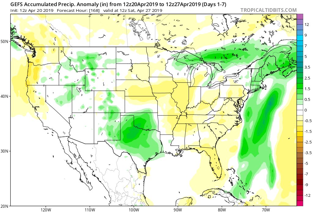
7-Day Precipitation: Rainfall is expected to run below average through the period.
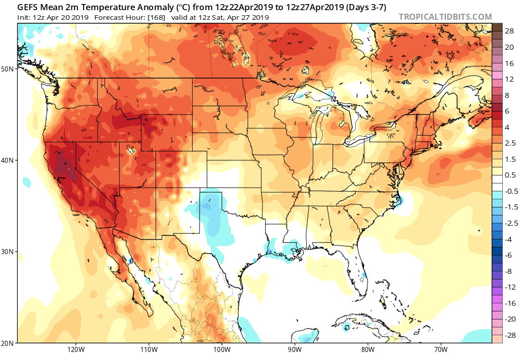
7-Day Temperatures: Above normal temperatures are expected through the period.
Severe Weather: Widespread severe weather isn’t anticipated through the period, locally.
Summary: A much quieter period is expected for the week ahead, especially when compared to this past week. High pressure will build in and supply pleasant weather as we go through Easter and into the new work week. A weak system will result in scattered showers and thunderstorms Tuesday into early Wednesday, but excessive rain and strong to severe thunderstorms aren’t expected. High pressure will then return and lead to dry, pleasant weather conditions as we move into at least the first half of next weekend.
Permanent link to this article: https://indywx.com/2019/04/20/agwx-and-weekly-severe-weather-outlook/