A sunny, but hot Saturday is on deck before we introduce strong thunderstorms into the picture for the second half of the weekend. We also look ahead to the pattern…
You must be logged in to view this content. Click Here to become a member of IndyWX.com for full access. Already a member of IndyWx.com All-Access? Log-in here.
You must be logged in to view this content. Click Here to become a member of IndyWX.com for full access. Already a member of IndyWx.com All-Access? Log-in here.
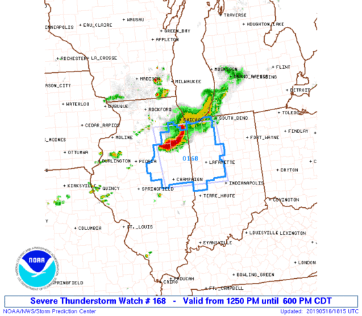
The Storm Prediction Center has issued a Severe Thunderstorm Watch in effect until 7p.
Greatest concern has to do with the Southwest flank of the thunderstorm complex that will continue to push southeast into the evening hours. (This is the same complex of storms that moved through MN and WI earlier this morning).
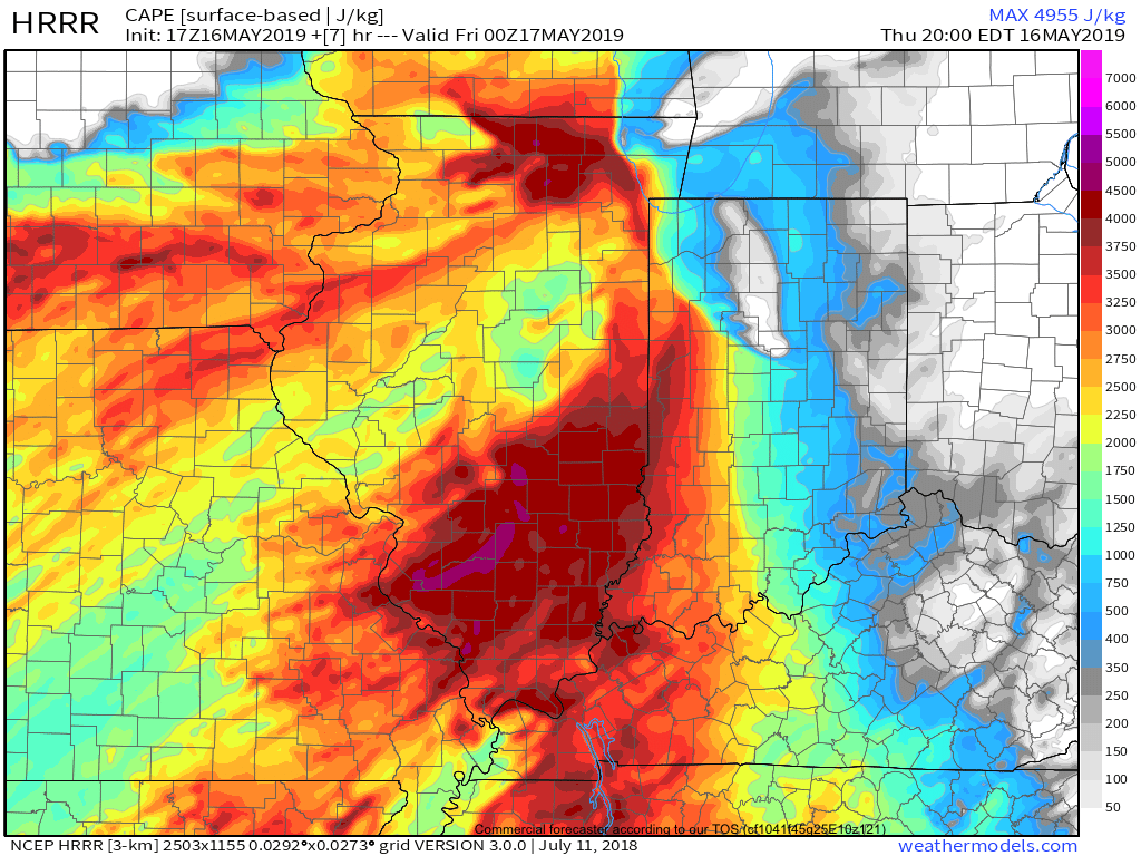
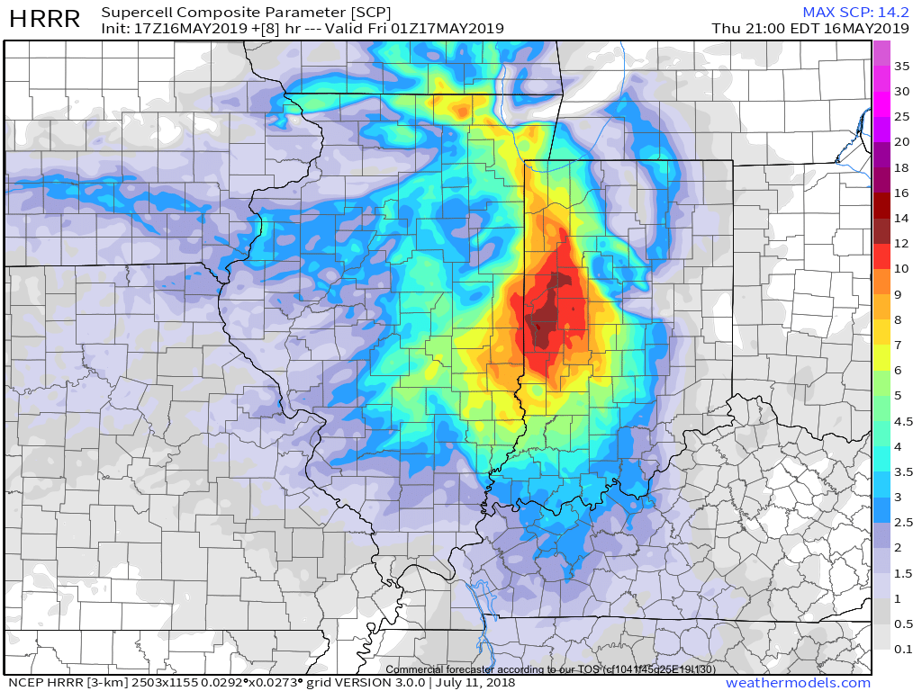
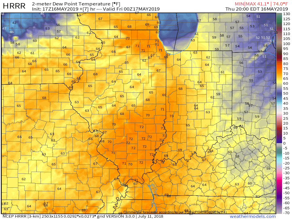
As we look at the ingredients needed for severe weather, there’s reason to believe this complex will hold together, including occasionally producing severe weather (large hail and damaging winds remain the biggest concerns) into portions of central Indiana by early to mid evening (5p-8p time frame).
This shouldn’t have any impact on another, more widespread, complex of storms that will initiate well to our north late tonight before rumbling south into central Indiana around, or just after, midnight in a weakening state…
You must be logged in to view this content. Click Here to become a member of IndyWX.com for full access. Already a member of IndyWx.com All-Access? Log-in here.
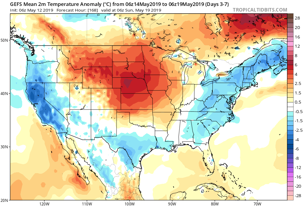
An expanding upper level ridge will drive the warmest air so far this season into the Ohio Valley, including central Indiana, as we get set to close the work week and head into next week.
This will not only deliver mid to upper 80s, but the first truly “oppressive” feel of the season as moist Gulf of Mexico air flows northward into the Ohio Valley. At times, dew points will approach the 70 degree mark.
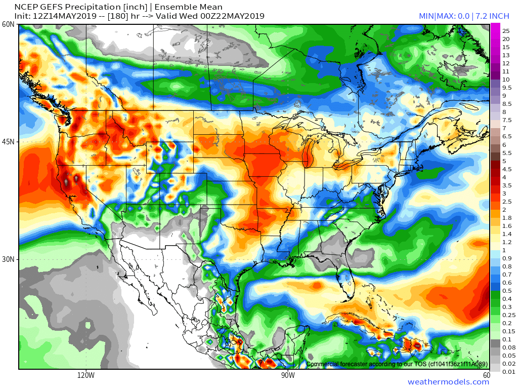
Though the pattern will turn warm and humid, the worst of the heavy rain events are expected to remain to our west-northwest. (Unfortunately, this pattern is one that will lead to a multi-day severe weather and eventual flood threat for the Plains into the upper Midwest).
That isn’t to say we won’t see rain and storms at times (most numerous Thursday night across northern and east-central Indiana, Sunday afternoon across all of the state, and again Tuesday), but instead the most concentrated heavy rain and severe potential will be focused from OK, MO, IA, and into MN and WI over the upcoming 7-day period. Instead of us looking at widespread 2″ to 4″ totals, we’re instead looking at 7-day rainfall amounts around an inch, with locally heavier amounts.
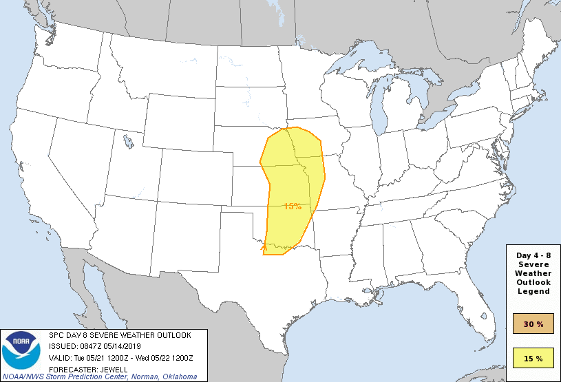
From a severe perspective, similar to the heavy rain events, this, too, is expected to remain to our west for the better part of the upcoming 7-day period. While storm chasers coverage on the Plains this weekend into next week, we’ll, thankfully, be watching the bulk of the action from afar for the better part of the period.
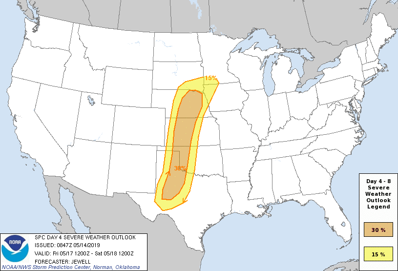
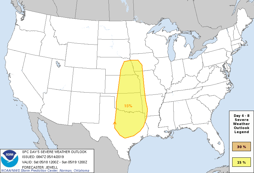
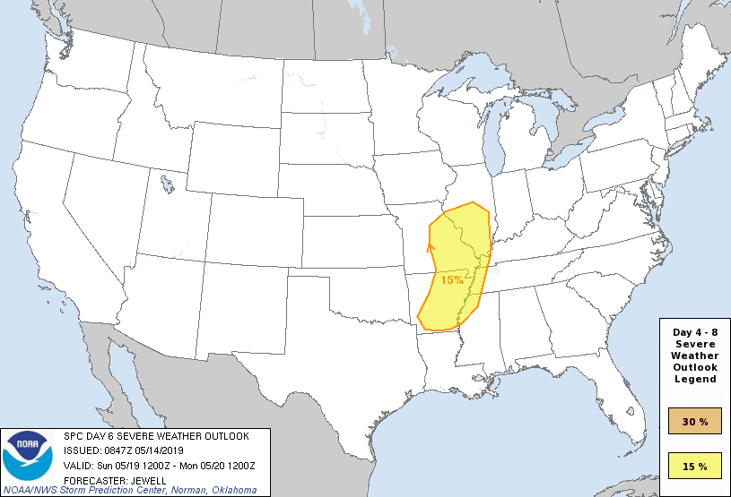
Days 4-8 Severe Weather Outlook, courtesy of the Storm Prediction Center (SPC), can be found below:
Permanent link to this article: https://indywx.com/2019/05/14/watching-from-afar-summer-like-warmth-but-heaviest-rain-severe-threat-remains-nw-of-immediate-region/
7-Day Precipitation: Rainfall is expected to run below average through the period.
7-Day Temperatures: A period of transition awaits during the week. While we’ll start significantly cooler than normal, a major warming trend will take hold late in the period. Overall, the 7-day period will run very close to average, but we get there through unseasonably chilly air giving way to a summer-like feel late in the week.
Severe Weather: A quiet period awaits from a severe perspective.
Summary: While we’ll have to deal with a couple of weak and moisture-starved systems this week, overall, we’re looking at a much quieter time of things compared to recent weeks past. Nuisance variety showers will remain today and Monday, but most rain gauges will pick up a tenth of an inch or less. Another system will deliver light showers Wednesday. Perhaps a “more exciting” system will arrive Thursday night-Friday with thunderstorms. This will come on the nose of the much warmer and more humid air surging north into the Ohio Valley. Next weekend will feel like summer around central Indiana…
You must be logged in to view this content. Click Here to become a member of IndyWX.com for full access. Already a member of IndyWx.com All-Access? Log-in here.
You must be logged in to view this content. Click Here to become a member of IndyWX.com for full access. Already a member of IndyWx.com All-Access? Log-in here.
You must be logged in to view this content. Click Here to become a member of IndyWX.com for full access. Already a member of IndyWx.com All-Access? Log-in here.
You must be logged in to view this content. Click Here to become a member of IndyWX.com for full access. Already a member of IndyWx.com All-Access? Log-in here.