Timing Sunday Severe Potential…

A cold front will slice into a hot and humid air mass Sunday evening.  The daytime hours Sunday are expected to provide plenty of sunshine to go along with that hot and increasingly humid air mass (courtesy of strong southwest winds), but things will turn stormy Sunday night.  We’re growing close enough now to begin to bracket the most likely time for potentially strong to severe thunderstorms and focusing in on the hours between 10p and 2a.  Damaging straight line winds are of greatest concern, but large hail and a quick spin-up tornado can’t be totally ruled out.  It’ll be important to set those weather radios before going to bed tomorrow night, or have a means of getting the latest watches and warnings.

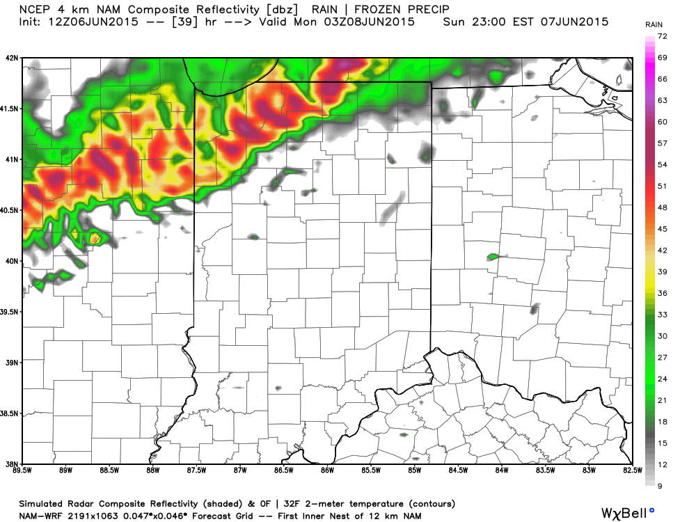
Forecast radar 11p Sunday

11p
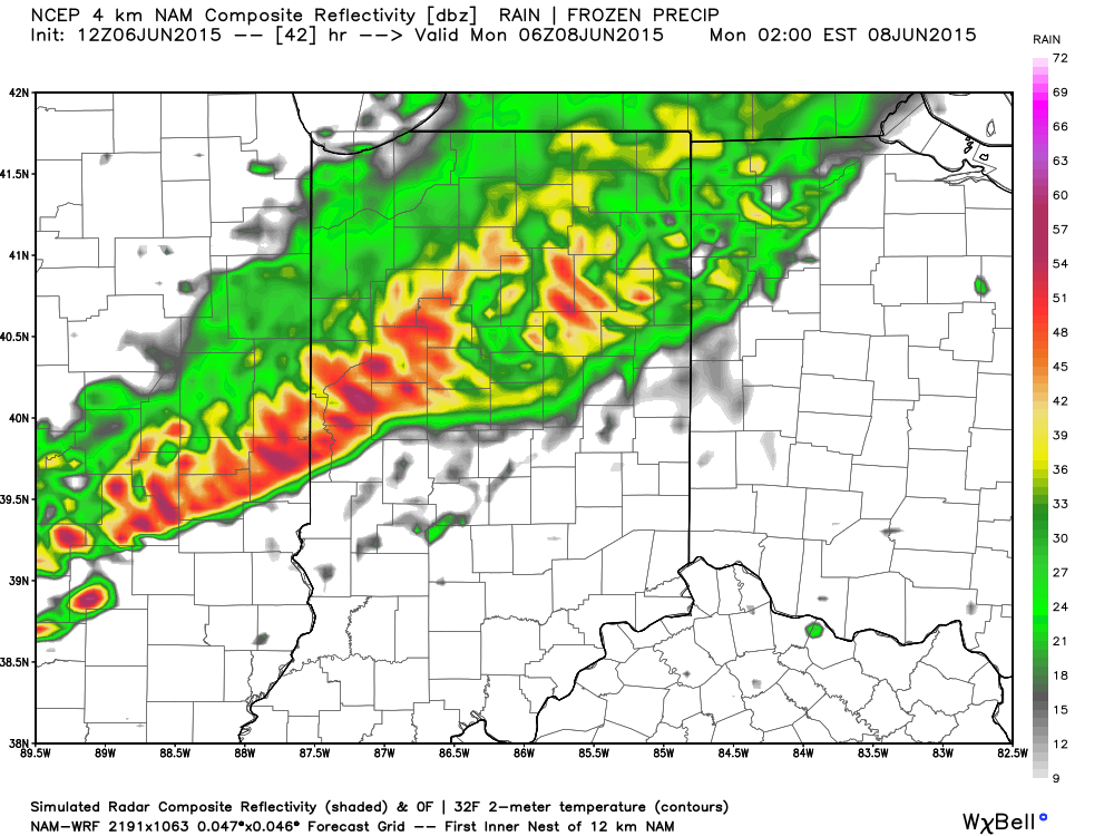
Forecast radar 2a Monday

2aForecast radar 8a Monday

8a
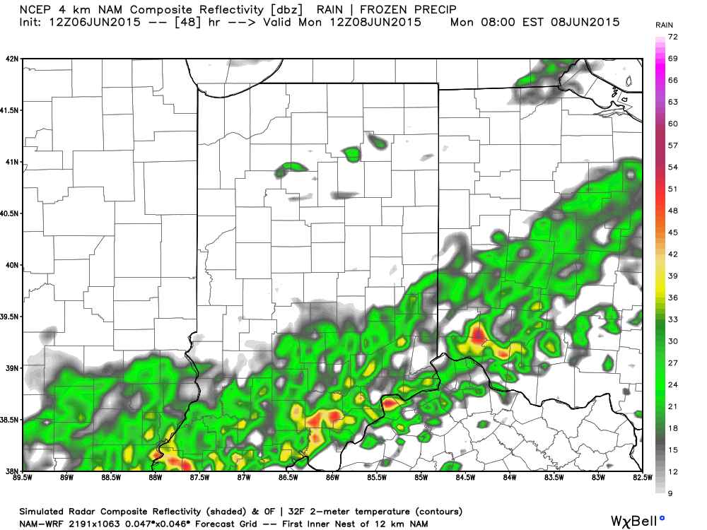
The line of storms will weaken in rather dramatic fashion as they continue to push south into the lower Ohio Valley and Tennessee Valley Monday morning.

Stay tuned.

Warmer Days; Continuing To Watch Sunday Evening…

Screen Shot 2015-06-03 at 9.37.15 PMHighlights:

  • More like summer
  • Mostly dry weekend
  • Keeping a close eye on Sunday night storm threat
  • Unsettled to open the week

The story to wrap up the work week will be one much more typical of early June- warmer days are on deck with increasing humidity.  The combination of the increasingly muggy air mass coupled with a weak upper level disturbance, could ignite a shower or storm Friday.  Most of the day will be dry, however.  The upcoming weekend will feature beautiful weather conditions- dry and warm to hot.  We continue to watch a storm complex that could deliver a round of strong to severe cells (damaging straight line winds being the biggest concern) Sunday evening and night. We’ll have to tighten up potential timing as we progress closer to Sunday, but think most of the daytime hours will be dry.  Early next week will likely open a bit unsettled.

Upcoming 7-Day Rainfall Potential: 0.50″ – 0.75″

Strong To Severe Storms Possible Tuesday PM…

Screen Shot 2015-05-25 at 7.13.18 PMHighlights:

  • Strong to severe storms possible Tuesday afternoon/ evening
  • Drier skies Thursday-Friday
  • Weekend cold front

hires_ref_indy_28Forecast radar above (courtesy of Weatherbell.com) shows our next weather concern and that has to do with an upper air disturbance moving northeast tonight into Tuesday.  This will likely ignite scattered strong to severe thunderstorms across the area Tuesday afternoon and evening.  Remain weather-aware tomorrow for the possibility of these severe storms. Large hail is the big concern.  Should we see morning sunshine of significance then that would “up the ante” for afternoon severe potential.  We remain in a rather unsettled, warm, and humid pattern this week, but there will be plenty of dry time.  Coverage of thunderstorms Thursday and Friday will be diminished from what we can expect tomorrow and Wednesday.  A cold front will arrive over the weekend, helping to increase shower and thunderstorm coverage.

A blend of short and mid range computer guidance prints out an average of 1.5″-2″ of rain over the upcoming ten days.  This is needed after what’s been several weeks in a row of a lack of widespread rains.

Severe Weather Potential Today…

We continue to closely monitor the threat of severe weather today. Best chances of severe thunderstorms likely will come this afternoon into the early evening hours from west to east,…

You must be logged in to view this content. Click Here to become a member of IndyWX.com for full access.  Already a member of IndyWx.com All-Access?  Log-in here.