Still Eyeing Mid Week Storms; Windy And Colder To Close The Week…
 Highlights:
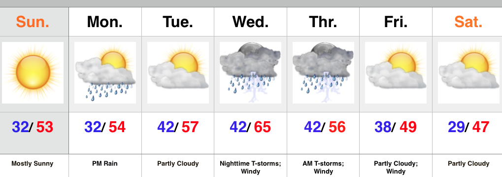
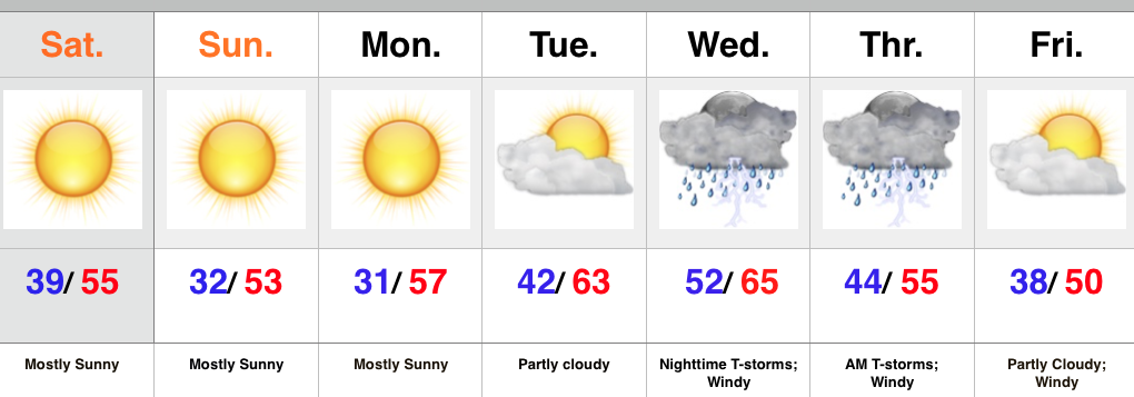
- Wednesday night storms
- Very windy to close the week
- Colder Friday
The overall set-up over the next couple days will feature a strong autumn storm coming off the Rockies (today), crossing the Plains (Wednesday), and heading northeast into the Great Lakes to offer up some “fresh water fury!” (Thursday).
Here’s the track of our storm, courtesy of Weatherbell.com.


 We still need to monitor things closely for the potential of severe weather Wednesday evening, but latest data would suggest a lower chance of severe, overall. Certainly not worth letting your guard down, but the lack of moisture return and timing are both on our sides in this particular event. Localized damaging straight line winds are still of greatest concern of any of the severe elements across central IN and this would be for Wednesday night.
Here’s a look at the latest simulated radar for 10p Wednesday. As we always say, don’t pay particularly close attention to the precise time. This should be used as guidance as what the radar may look like Wednesday evening.
 As mentioned above, the speed, timing, and lack of moisture return strongly argue against significant rainfall with this storm. We’ll forecast around 0.25″ with locally heavier totals in storms. Not a big deal from a precipitation perspective.
What is a big deal is the wind on the backside of the low as northwest gusts really crank in the Thursday-Friday time frame (30-40 MPH). Needless to say, Thursday isn’t a day to wear a hat. 🙂
Longer term, data continues to argue against any sort of sustained chill through the rest of November. We note the SOI is actually positive right now. This is certainly unusual with the ongoing El Nino and well above the base state (a warm sign).

The MJO is also projected to rumble through the warm Phases of 2 and 3 over the next few weeks. Note these are overall warmer than normal phases in November.