You must be logged in to view this content. Click Here to become a member of IndyWX.com for full access. Already a member of IndyWx.com All-Access? Log-in here.
A cold front is slowly sinking south and will feature a weak wave of low pressure that will track along the boundary Tuesday. The end result spells for increased chances of showers and thunderstorms across central Indiana over the upcoming 24-36 hours.
Initially, we expect an area of thunderstorms to push south and potentially impact north-central portions of the state later tonight. The latest high resolution NAM forecast radar gives us an idea what the radar may look like late tonight- just after midnight.
Some of the storms across the northern third of the state may “pulse” to severe levels this evening, including the potential of large hail and damaging winds. (This complex will weaken as it surges south later tonight).
As we turn our attention to Tuesday, scattered to numerous showers and thunderstorms are expected, especially during the afternoon and evening hours. A few strong storms are possible, including locally heavy rain.
Eventually, drier times will return by mid-week. Beforehand, most central Indiana rain gauges should receive somewhere between 0.50″ to 1″ of rain. With a rich, tropical airmass in place, there will be some locally heavier totals.
Image courtesy of weathermodels.comImage courtesy of weathermodels.com
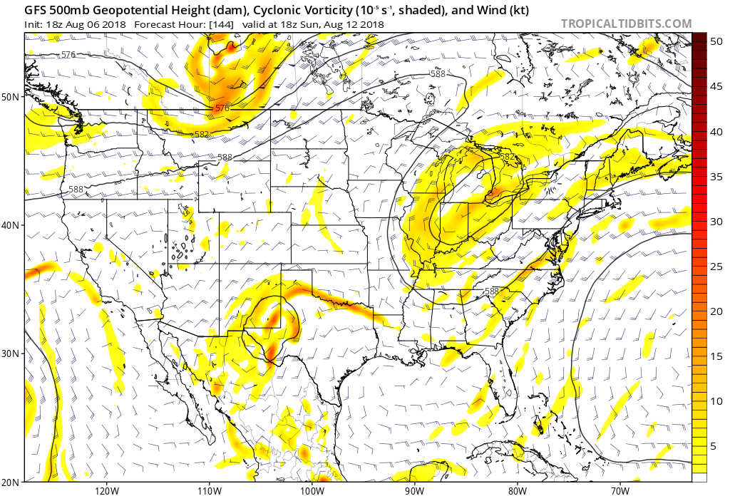
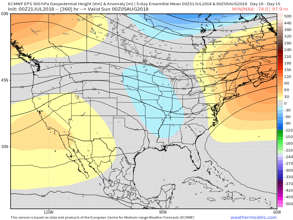
As the cold front moves south during the midweek stretch, drier times will return Wednesday and Thursday. With that said, the drier regime won’t last long, as a cut off upper low “mucks” things up over the weekend. While it certainly won’t rain the entire time, daily rain chances will return late Friday, continuing throughout the weekend. There’s no need to cancel any outdoor plans, but have the rain gear handy, as you’ll likely need it at times throughout the weekend.
A “cut off” upper low will impact the region this weekend. Image courtesy of tropicaltidbits.com.
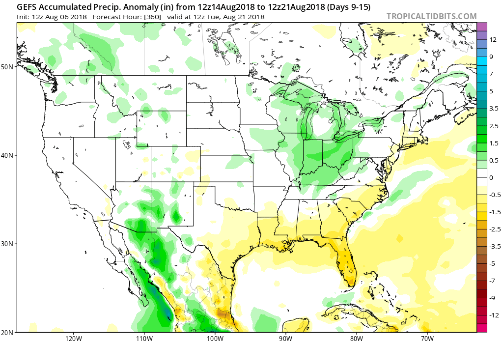
Speaking of rain and overall unsettled times, the pattern sure looks active around these parts into the mid and longer range. More on that in future updates…
Longer range data suggests wetter than normal times throughout the Ohio Valley mid and late August. Image courtesy of Tropicaltidbits.com.
You must be logged in to view this content. Click Here to become a member of IndyWX.com for full access. Already a member of IndyWx.com All-Access? Log-in here.
It was a tale of two worlds across the state on Friday. Despite a couple of non-severe, gusty showers that impacted western portions of the state Friday evening, the majority of the “excitement” took place in the eastern half of the state. Multiple large hail, wind, and tornado reports were included along with heavy rain. When we look at storm total rainfall through 8a today, we note widespread 2″ to 3″ amounts across eastern Indiana. Muncie recorded amounts in excess of 3″!
As we look ahead, our weekend weather will continue to be dominated by a “cut off” area of low pressure. As it meanders around the region, shower and thunderstorm chances will remain. Aerial coverage of rain will reach greatest heights during the afternoon and evening hours today and Sunday. With the colder air aloft, don’t be surprised if a few of the stronger showers produce hail.
Additionally, highs today will run close to 10° below the average high of the mid-80s.
As we open up the new week, showers and embedded thunder will also be around Sunday before the upper low begins to lose it’s influence on the region. We’ll maintain shower chances into the new work week, but overall coverage should be diminished Monday.
Shower and embedded thunder chances remain Sunday. Image courtesy of weathermodels.com.
A couple of cold fronts will make a run at the Ohio Valley over the upcoming week. The first will pass through during the midweek stretch, followed by a stronger frontal passage as we get ready to head into the weekend. Each front will provide a shower/ thunderstorm threat. A stronger push of pleasantly refreshing air should arrive behind front number 2 as we head into next weekend.
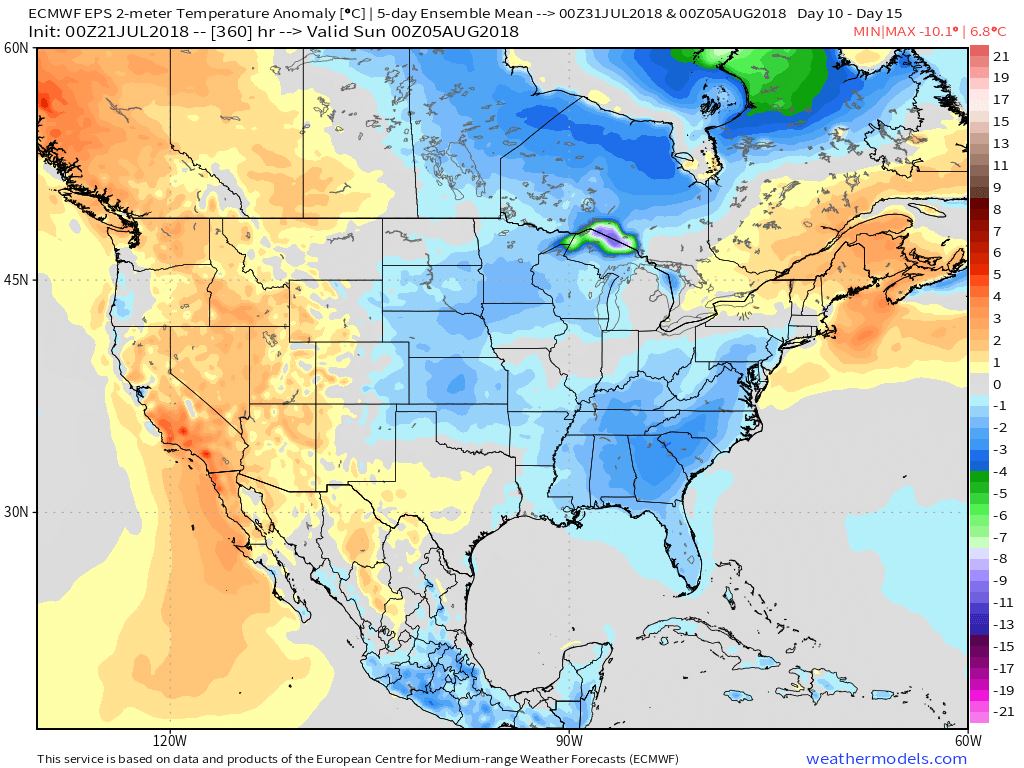
On the temperature note, models continue to show a cooler than average pattern as we open August.
Longer term, the NEW JMA Weeklies suggest the worst of the summer heat is now behind us as they keeps the Weeks 3-4 time period unseasonably refreshing…
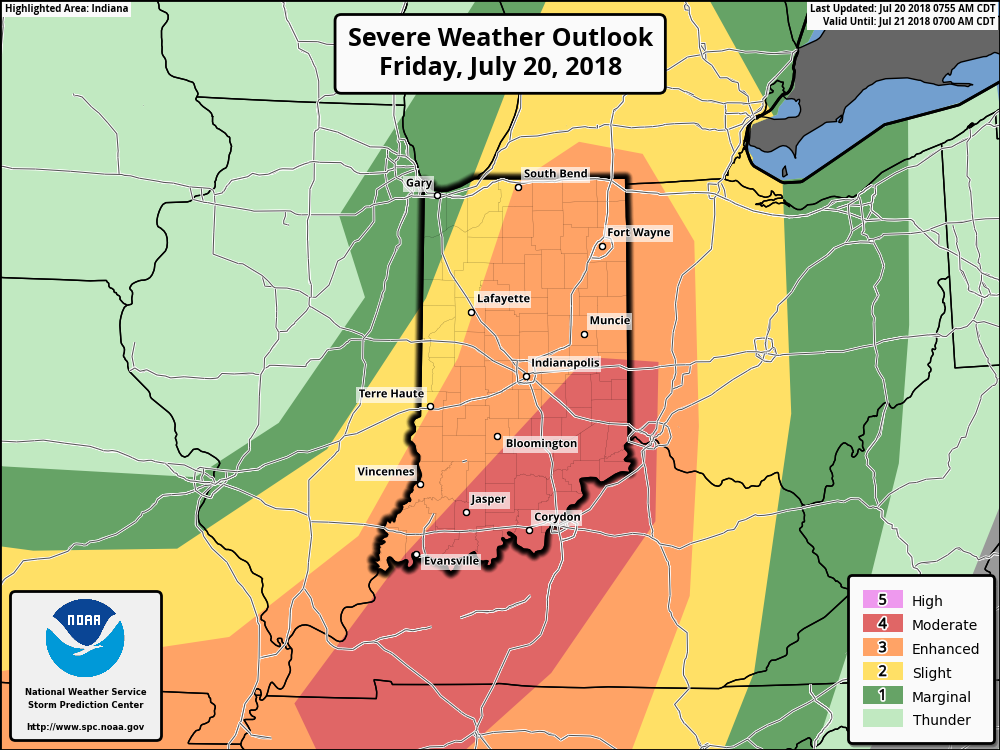
We continue to closely monitor the potential of severe weather this afternoon and evening across central and eastern portions of the state. The latest outlook from the Storm Prediction Center includes an ‘Enhanced’ risk for the majority of the state and has upgraded southeastern portions of the state into a rare ‘Moderate’ risk.
Part of the reason behind today’s severe weather has to do with an overall pattern shift. An intense short wave trough (especially for this time of year) will dig into the Great Lakes and Ohio Valley. At the surface, an area of low pressure will track from southern WI (this morning) before “cutting off” over the Ohio Valley this weekend. Additionally, a couple of frontal boundaries will swing through the state- the most potent being the boundary that surges east this afternoon and evening. The combination of ingredients spell trouble across at least a portion of the region- especially from Indianapolis and points south and east this afternoon and evening.
High resolution forecast radar products are likely struggling with handling the specifics today, but we think one or two lines of storms will track southeast across the state this afternoon and evening. The risk of severe weather will diminish from 7p to 8p from northwest to southeast across the state. Greatest concerns from a severe perspective include the potential of large, damaging hail and straight line winds. Additionally, a tornado or two can’t be ruled out. It’ll be important to remain weather-aware this afternoon and evening. Have a means of getting the latest information with respect to watches and warnings that may be issued later today from the National Weather Service.
As we look ahead, though the severe threat will end, unsettled times will remain this weekend. In fact, a couple of the stronger showers Saturday afternoon could contain hail (below severe levels), due to the cold air aloft associated with the upper low. Greatest coverage of showers this weekend will come during the afternoon and evening hours both Saturday and Sunday.
 Some of the storms across the northern third of the state may “pulse” to severe levels this evening, including the potential of large hail and damaging winds. (This complex will weaken as it surges south later tonight).
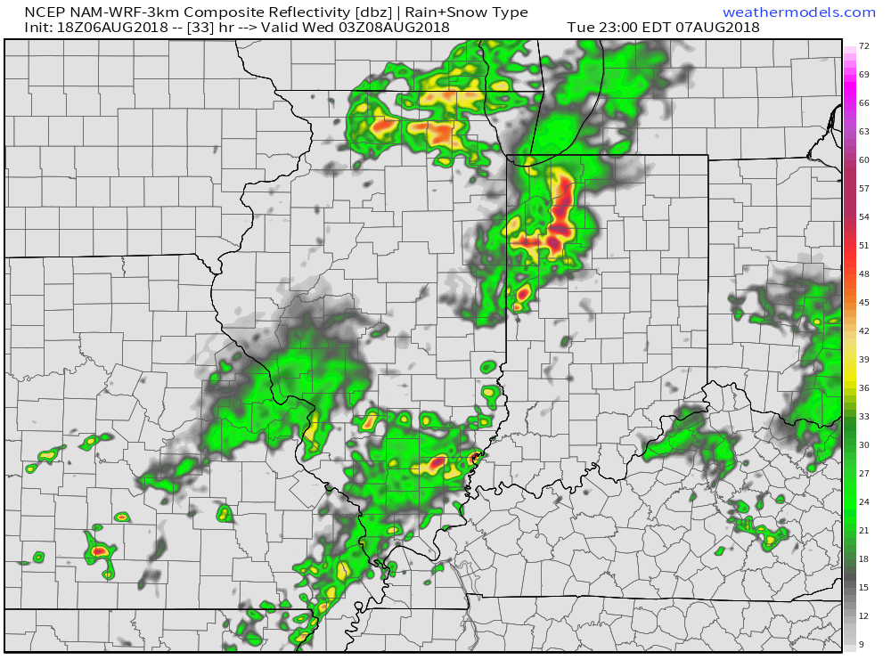 Eventually, drier times will return by mid-week. Beforehand, most central Indiana rain gauges should receive somewhere between 0.50″ to 1″ of rain. With a rich, tropical airmass in place, there will be some locally heavier totals.
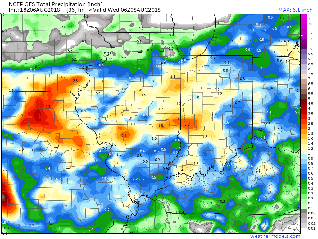
 As we look ahead, our weekend weather will continue to be dominated by a “cut off” area of low pressure. As it meanders around the region, shower and thunderstorm chances will remain. Aerial coverage of rain will reach greatest heights during the afternoon and evening hours today and Sunday. With the colder air aloft, don’t be surprised if a few of the stronger showers produce hail.
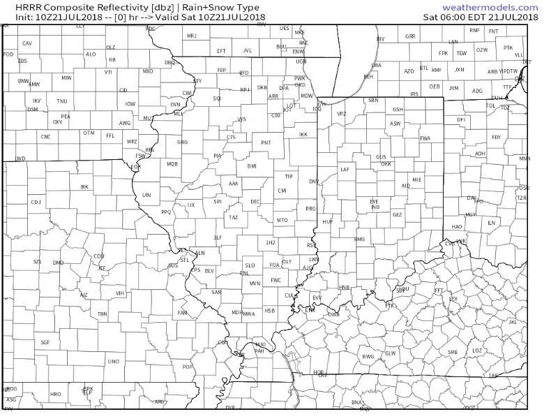 Additionally, highs today will run close to 10° below the average high of the mid-80s.
 Longer term, the NEW JMA Weeklies suggest the worst of the summer heat is now behind us as they keeps the Weeks 3-4 time period unseasonably refreshing…
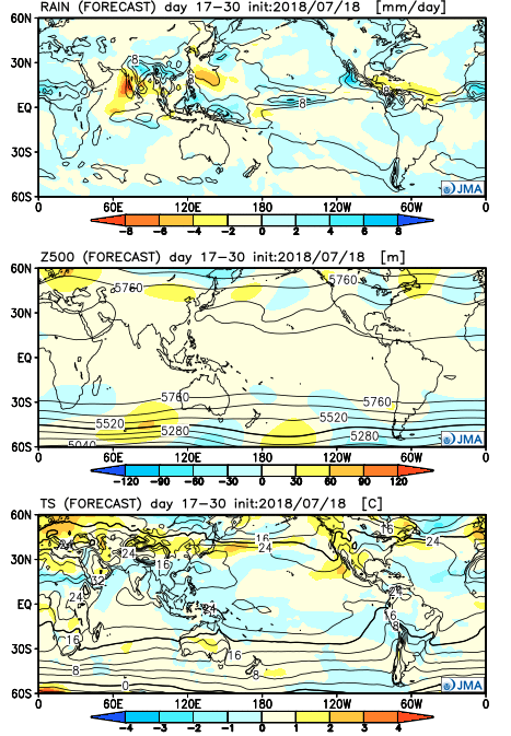
 Part of the reason behind today’s severe weather has to do with an overall pattern shift. An intense short wave trough (especially for this time of year) will dig into the Great Lakes and Ohio Valley. At the surface, an area of low pressure will track from southern WI (this morning) before “cutting off” over the Ohio Valley this weekend. Additionally, a couple of frontal boundaries will swing through the state- the most potent being the boundary that surges east this afternoon and evening. The combination of ingredients spell trouble across at least a portion of the region- especially from Indianapolis and points south and east this afternoon and evening.