Category: Record Cold

VIDEO: Wintry Start To The Day Gives Way To Additional Snow Showers This Afternoon; Wet Saturday Ahead…

Updated 04.21.21 @ 7:25a

You must be logged in to view this content. Click Here to become a member of IndyWX.com for full access.  Already a member of IndyWx.com All-Access?  Log-in here.

Permanent link to this article: https://indywx.com/2021/04/21/video-wintry-start-to-the-day-gives-way-to-additional-snow-showers-this-afternoon-wet-saturday-ahead/

VIDEO: Snow Arrives Late Afternoon; Record Cold Expected Wednesday…

Updated 04.20.21 @ 7:42a

You must be logged in to view this content. Click Here to become a member of IndyWX.com for full access.  Already a member of IndyWx.com All-Access?  Log-in here.

Permanent link to this article: https://indywx.com/2021/04/20/video-snow-arrives-late-afternoon-record-cold-expected-wednesday/

VIDEO: Snowfall Map Issued; Potential To Shatter Records Wednesday Morning…

Updated 04.19.21 @ 11:10p In looking over the latest computer models, we don’t see need for any significant changes to our ongoing forecast built into this morning’s Client video update.…

You must be logged in to view this content. Click Here to become a member of IndyWX.com for full access.  Already a member of IndyWx.com All-Access?  Log-in here.

Permanent link to this article: https://indywx.com/2021/04/19/video-snowfall-map-issued-potential-to-shatter-records-wednesday-morning/

Long Range Update: Heat Comes In Spurts, But Still A Long Way Off From Sustained Warmth…

After a chilly May featuring all-time record cold to begin the month, the flip to warmer air has been welcome by many over the past 24 hours. This warmer regime will continue into the weekend before getting beaten back next week. This is due to a closed off upper level low that will actually manufacture it’s on chill across the Ohio Valley, Mid-Atlantic, and Southeast during this time frame.

Sometimes it can be like pulling teeth to get these kind of features to leave and models can struggle (case in point, this upper low was originally modeled to be located over Nova Scotia- NOT the Southeast and Mid-Atlantic)!

Nevertheless, we believe the one time expected surge of heat next week will only be a scenario of “delayed, not denied.” By the time we head into Memorial Day weekend, we continue to believe legitimate summer warmth will move in (85°-90° stuff).

The new CFSv2 agrees with the European ensembles above.

Longer range (last few days of May and early June) will depend heavily on what goes on with a combo of the MJO and EPO/ PNA. 2 of 3 of these signals argue for cooler air to return during that time period.

We shall see how it plays out, but our official lean is towards the cooler side of things after the Memorial Day heat. From a precipitation perspective, after the short-term wet period, overall dry conditions are set to return as we wrap up May.

Permanent link to this article: https://indywx.com/2020/05/15/long-range-update-heat-comes-in-spurts-but-still-a-long-way-off-from-sustained-warmth/

Major Flip On Deck; Discussing Longevity…

Indianapolis is running a whopping 8° below normal month-to-date. We’ve set new daily and all-time records already this month for the cold. Note the vast nature of this May chill.

If you’re not a fan of the late season chill, hang in there, as a major flip in the pattern awaits. We alluded to this possibility in our May Outlook and it continues to look like a rather abrupt change is a couple of days away. While we’re dealing with frost this morning in spots across east-central Indiana, it’s looking more and more likely that the first true summer-like surge of air for the season arrives Thursday into the weekend. Warmth will be accompanied by a significant uptick in humidity levels.

The Week 2 period looks warmest, relative to average, and should feature at least a couple of days with highs approaching the 85°-90° mark.

While most data maintains a warmer pattern to close the month, there are a couple of items to pay close attention to as we try and understand the longevity of said warmth.

  1. The MJO is forecast to remain “bottled up” in the wheelhouse through the next couple of weeks. Thereafter, there are indications that the MJO might become more amplified and it’ll be important to keep an eye on what phase(s) it’ll move through as we get set to close May/ open June.

2. The PNA is forecast to take a negative dip which supports the coming flip to warm. However, recent ensemble data is bullish on a move towards a positive (some data shows even strongly so) state around or just after Memorial Day. This would suggest the window of warmth may be limited in duration. Simply based on looking at the chart below, one could build a case for a cool open to meteorological summer.

Finally, on the precipitation front, a wetter pattern is anticipated to accompany the warm change, but longer range data points towards this being only a temporary wetter regime. In fact, recent models are beginning to agree on a dry close to May/ open to June.

Much more later!

Permanent link to this article: https://indywx.com/2020/05/12/major-flip-on-deck-discussing-longevity/

VIDEO: New Daily And May All-Time Record Low Established; Looking Ahead To The Upcoming Week…

You must be logged in to view this content. Click Here to become a member of IndyWX.com for full access.  Already a member of IndyWx.com All-Access?  Log-in here.

Permanent link to this article: https://indywx.com/2020/05/09/video-new-daily-and-may-all-time-record-low-established-looking-ahead-to-the-upcoming-week/

In Position To Challenge The All-Time Record Low For May Saturday; Discussing Degree Of Moderation Late Month…

We may only be a few weeks away from meteorological summer, but you wouldn’t know it. Instead, we’re talking about the potential of wet snow mixing in with a cold rain to close the work week and threat of lows falling into the 20s Saturday morning!

A strong cold front will settle south across the Ohio Valley Friday morning. In response to the front moving south, surface low pressure will organize along the boundary across the TN Valley Friday morning before roaring northeast and off the New England coast Saturday morning.

Widespread light rain will overspread the southern half of the state during the wee morning hours Friday, continuing into the mid to late morning before pushing off to the east. This will be a cold rain and may even mix with wet snowflakes at times before ending.
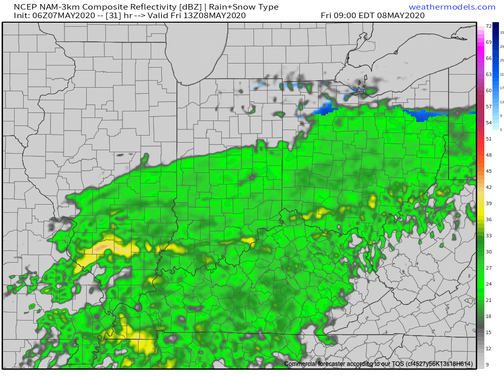
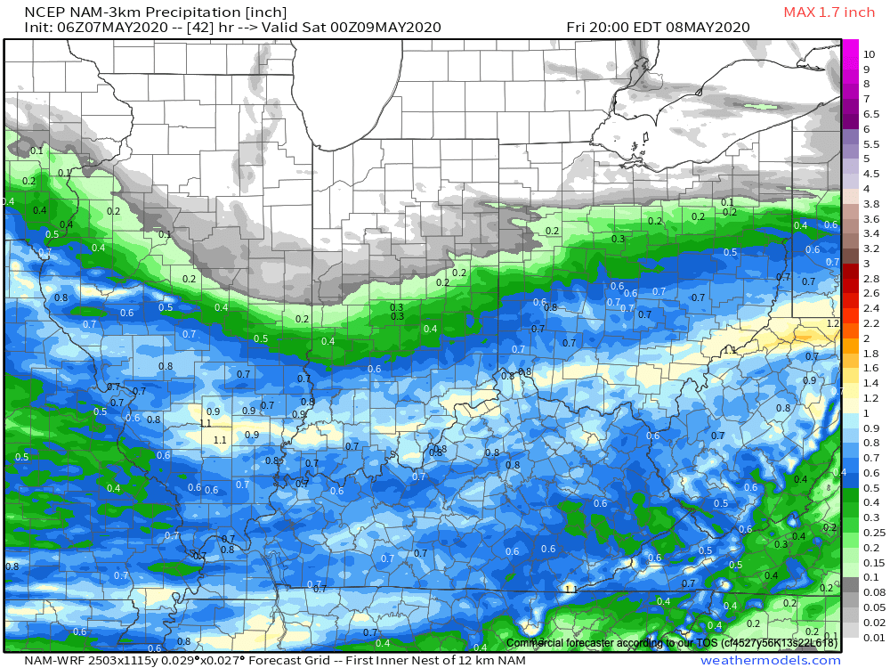
This won’t be a huge precipitation producer across central Indiana with most checking in between 0.10″ and 0.25″ (heavier amounts expected across southern Indiana).
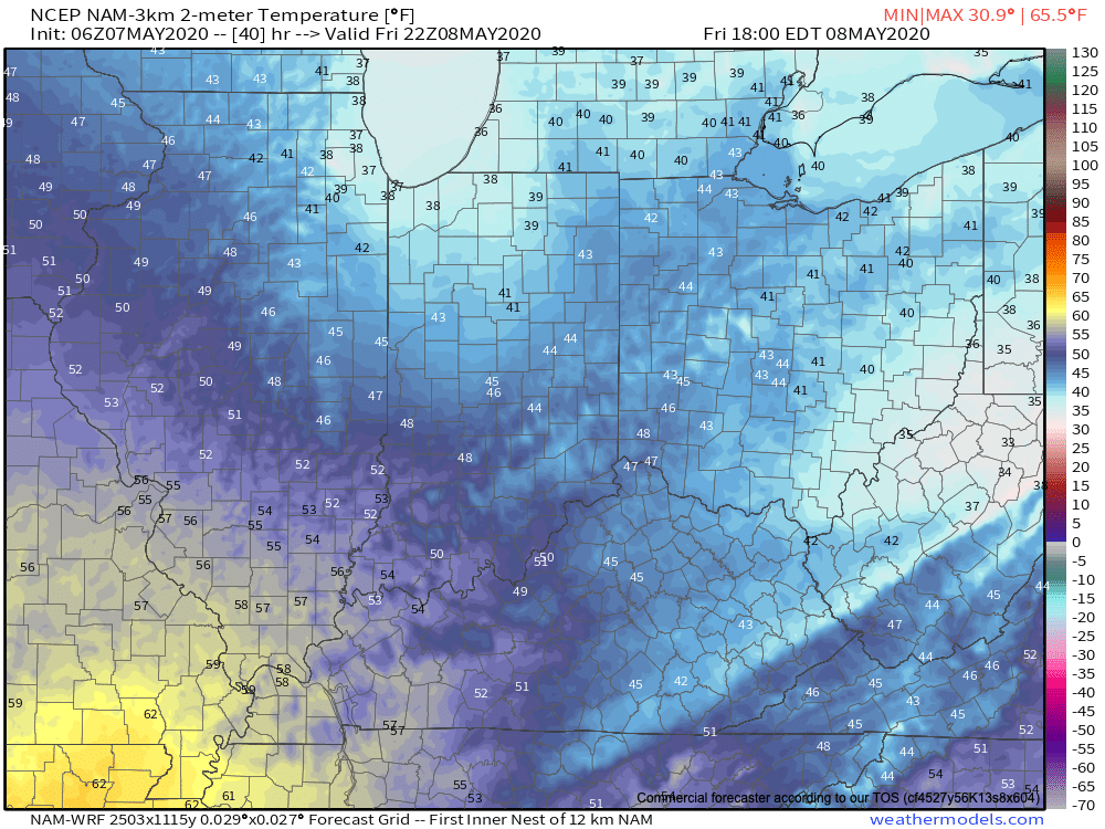
Temperatures will slowly fall through the 40s during the daytime Friday. (Yes, we’re talking about May 8th)!
That then sets us up to at least be in position to break the all-time record low for the month of May (28° set in 1966). This will be an airmass with arctic origins and if high pressure can clear us out in time Friday night, overnight lows by Saturday morning are likely to fall into the upper 20s. High resolution guidance takes IND to between 26° and 27° while the European data remains consistent at 28°. Regardless, this will be “rare air” for so late in the season. Those with ag interests should use today to prepare for a hard freeze Friday night into Saturday morning.

Looking ahead, the bulk of the upcoming 7-day period will remain much cooler than average, but there are at least hints of a potential pattern change during the 8-10 day period. The European data is much warmer than the GEFS or new JMA Weeklies that are in-house. Additionally, the teleconnections don’t scream an all-out pattern change. Regardless, a period of moderation would certainly be welcome after this unusually chilly spell. We’ll have much more on this later today with our long range video update. Stay tuned.

Permanent link to this article: https://indywx.com/2020/05/07/in-position-to-challenge-the-all-time-record-low-for-may-saturday-discussing-degree-of-moderation-late-month/

VIDEO: Record Territory; Looking Ahead To Late May…

You must be logged in to view this content. Click Here to become a member of IndyWX.com for full access.  Already a member of IndyWx.com All-Access?  Log-in here.

Permanent link to this article: https://indywx.com/2020/05/06/video-record-territory-looking-ahead-to-late-may/

VIDEO: Multiple Shots Of Unseasonable Chill Through Mid Month; Timing Out Precipitation Chances…

You must be logged in to view this content. Click Here to become a member of IndyWX.com for full access.  Already a member of IndyWx.com All-Access?  Log-in here.

Permanent link to this article: https://indywx.com/2020/05/05/video-multiple-shots-of-unseasonable-chill-through-mid-month-timing-out-precipitation-chances/

VIDEO: Multiple Cold Weather Records Likely To Be Challenged Over The Next Couple Weeks…

You must be logged in to view this content. Click Here to become a member of IndyWX.com for full access.  Already a member of IndyWx.com All-Access?  Log-in here.

Permanent link to this article: https://indywx.com/2020/05/04/video-multiple-cold-weather-records-likely-to-be-challenged-over-the-next-couple-weeks/

IndyWx.com