Category: Rain

Big Fight Late Week Into The Weekend….

A major battle is taking shape between two of the more respected mid range forecast models for the late week period, including Super Bowl weekend.  The differences range from yet another wintry weekend, with a couple shots of accumulating snow to one that’s much milder and includes some rain.  Operational guidance today has remained consistent with what each particular model has been saying for the past 24-48 hours, adding further complexity to the upcoming late week period.  Usually we’d give a slight nudge towards the European output (warmer solution), but here in a bit we’ll tell you why we’re really not ready to hedge more towards one particular model over the other at this time frame.  Instead, we want to give it a couple more days and see which model “gives in” to the other.

Let’s dive into the European output first.

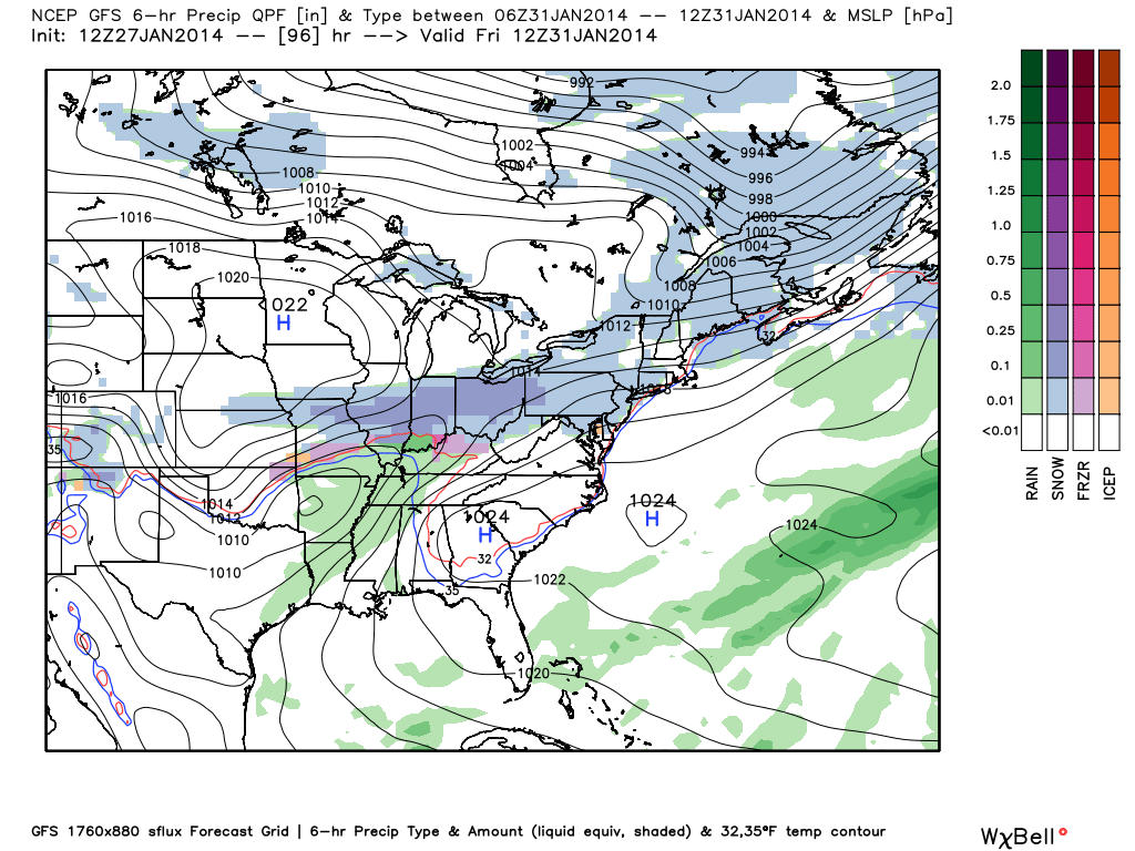
We note both models in relative good agreement on Thursday night into Friday as light snow overspreads the region (not a huge deal, but potentially enough to make for a slippery Friday morning commute).

As we move into Saturday the European tracks a developing surface low much further north than the GFS, resulting in a milder solution across central Indiana and a forecast that would produce a rain to snow solution Saturday as cold air quickly pours back into our region, with enough snow, perhaps, to produce a light accumulation Saturday night. However, it’s important to note, most European ensemble members are colder than the operational run and this is something we’ll need to continue to monitor.

As we head into early early next week, the European forecast model remains bullish on a potential major winter storm, with a favorable storm track for heavy amounts of wintry precipitation across central Indiana.  The time we’re eyeing for this next storm falls in the Monday night-Tuesday time period so we have plenty of time to monitor things and iron out the details…

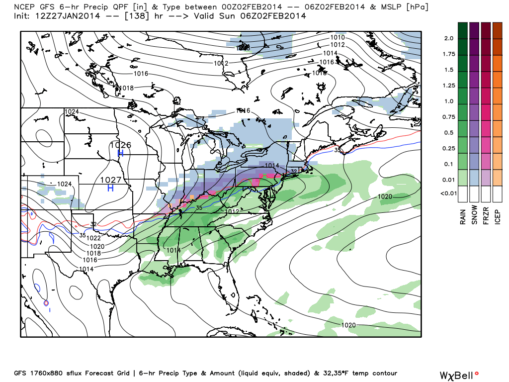
Now, as we look at the GFS forecast model, we note a colder solution from start to finish.  We have to raise an eye brow here as the track record of the GFS in the mid range is one that has been known to be biased too “flat” and too cold in handling similar patterns.  Is that saying the GFS is wrong here?  Absolutely not…nobody knows that at this juncture.  It is saying we have to rely on experience and remember similar patterns of the past, including the way the model “corrected” itself with time as we drew closer to the particular event in most cases…

Nonetheless, similar to the European, the GFS delivers a round of accumulating snow Friday morning, but is flatter (colder) with the initial wave and also leads to quite the overrunning event through the Ohio Valley.  As a matter of fact, we deal with two rounds of accumulating snow…Friday morning into the early afternoon and again Saturday morning, associated with yet another wave of low pressure.

1011


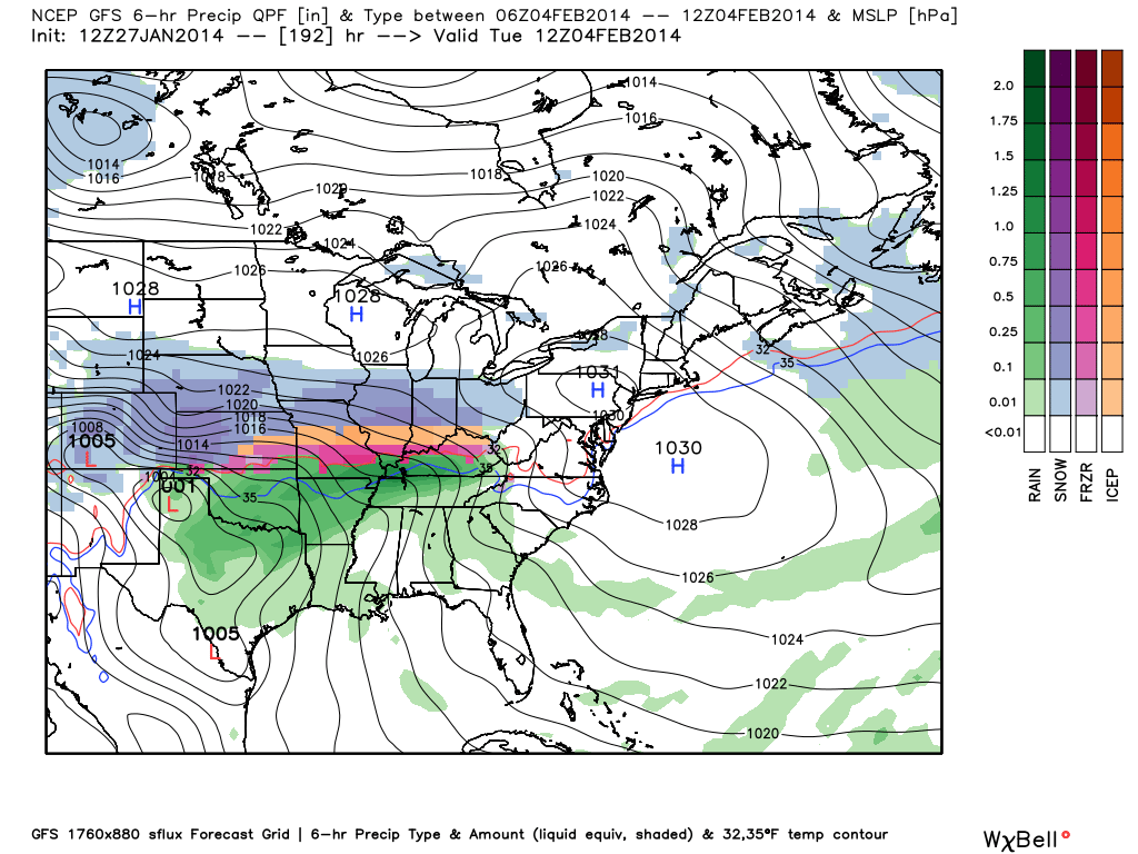
Of interest, the GFS also sees the potential strong winter storm that could impact our neck of the woods early next week.  Needless to say, the surface map next Tuesday morning would have snow lovers smiling in a big way should this come to fruition…

12


While we have many details to iron out late week and on into early next week, the overall weather pattern is one that we remain confident on and the results are cold and stormy (i.e. snowy) over the upcoming 10-14 day period.  As a matter of fact, long range teleconnections suggest we remain colder than normal and stormy through the majority of February. In short, there’s really no let up in sight from the overall cold and wintry time of things Hoosiers have grown oh so accustomed to this winter…

Permanent link to this article: https://indywx.com/big-fight-late-week-into-the-weekend/

Dangerous Flood Event Developing

Widespread rainfall totals are approaching 1″-2″ since the rain begin Friday across central Indiana.  When you look at the big-scale radar picture (snapped shortly after 8 o’clock this morning), you can understand the concern that’s ahead later this evening into Sunday, from a flooding perspective.

usa_None_anim

Latest projected rainfall numbers remain very consistent on the message we’ve been passing off  to you, the viewer, for a few days now…widespread 3″-4″ totals, with locally heavier amounts.

We think steady moderate to heavy rains continue for the better part of the day, but we note our short term, high-resolution, models targeting this afternoon and overnight for some extreme rainfall rates to develop.  Here’s a look at the simulated radar valid 7pm this evening:

hires_ref_indy_19

When you consider the snow melt and the rain that will have already fallen by this point, the stage is set for a very dangerous overnight flooding situation.  Flooding any time of the day is dangerous, but particularly so at night.  If you live in a flood prone area, PLEASE make sure to have a plan in place and consider perhaps spending the night with family or friends tonight as rapid water rise is certain to occur.

Permanent link to this article: https://indywx.com/dangerous-flood-event-developing/

A Lot Of Weather To Talk About…

Mother Nature seems determined to put us weather forecasters to hard work as we get set to head into the Christmas season and welcome in 2014.  We’re tracking a major flood situation that will unfold across central Indiana over the upcoming weekend, followed by a reload of the cold and potentially a storm with a more wintry component as we get closer to the New Year.

First things first and that’s the significant flood threat in the short-term period.  Without trying to go into scare tactic mode, current model data would result in a downright dangerous flooding event for many low lying and flood prone areas this weekend.  Rainfall numbers are extremely impressive with this event and with a deep tropical connection, widespread 3-4″ totals are certainly likely, including some localized higher amounts.  Note the latest European chart, courtesy of the model suite off Weatherbell Analytics.  Needless to say, the Gulf of Mexico is officially “open for business” and will help contribute to excessive rainfall totals and, as stated above, potentially a dangerous flooding event this weekend across central Indiana.

ecmwf_uvz850_noram_16

Latest numbers averaged off a variety of computer models would place just under 4″ of rainfall down by noon Sunday, most of which falls between Friday and Sunday morning.  We note (2) waves of enhanced rainfall intensity set to impact the region.  As of now we’re targeting Saturday afternoon and again late Saturday night/ Sunday morning for extremely heavy rain, shown below.

ecmwf_slp_precip_mc_14ecmwf_slp_precip_mc_17

We still have time to watch the data and monitor the track of the storm.  It’s possible the “heaviest of the heavy” axis of rain shifts somewhat in the days ahead,  but it’s also important to note that even a light to moderate rain event combined with a frozen ground and a solid snow pack still in place will lead to flooding problems here across central Indiana.  The question of whether or not we’ll deal with flooding here this weekend shouldn’t be asked, but instead the question that remains is just how severe will the flooding be?  Stay tuned and if you live or work in a flood prone area, we would recommend preparing now for flooding.

Now, as we look ahead and focus on the Christmas to New Years period our thoughts will shift from a flood threat in the near term to one that’s more wintry.  We’ll turn dramatically colder Sunday afternoon behind the big rain storm and that will set the stage for a colder-than-average run up to Christmas. In fact, latest raw numbers off some forecast model guidance has some frigid readings ahead next week (upper single digits not ruled out for lows).

The upcoming 10 days off the European forecast model charts show an interesting scenario with the coming thaw, but the key word is brief.  Note days 6-10 are back into a colder-than-normal regime.

tavg_anom_ecmwf_conus_1

Additionally, we think we’ll have to deal with another storm prior to the New Year period and with the colder air back in place, there’s the threat we could have to contend with a wintry side to the next storm.  The details with storm number two will have to wait until we finish dealing with the first storm and associated serious flood threat it’s presenting.

Permanent link to this article: https://indywx.com/a-lot-of-weather-to-talk-about/

Questions Around Next Week’s Arctic Front…

Your complete 7-Day forecast can be found in the video to the right of this article.

We continue to keep a close eye on the developing weather situation here late next week.  Many questions remain in regards to the track, timing, and strength of the cold air associated with an arctic cold front that will result in record-breaking cold for portions of the country next week.  How much fight will the southeast ridge put up as the front progresses east?  Will we have to deal with a wave of low pressure along the arctic boundary, potentially leading to some wintry “mischief” around these parts?  We hope to give some clarity around those questions by looking at some of the latest data below.

First, let’s take a look at the various model solutions for late next week.  It should be noted that the latest run of the National Weather Service’s GFS forecast model has taken a turn to look more like the overnight run of the European forecast model and suggests we have to deal with a wave of low pressure moving through here Friday into Saturday of next week, leading to the threat of wintry precipitation.  Taken at face value, this would suggest the threat of an accumulating snow event for central Indiana Friday night into Saturday morning of next week.  This is in stark contrast to the 0z GFS run signaling dry, cold weather during the aforementioned time frame.

Here’s a look at the latest GFS solution, valid next Friday evening:

gfs_namer_180_1000_500_thick_s

There’s relatively good agreement in the GFS ensembles, but, again, we’ll have to fine tune the details.  It’s encouraging to see the agreement in the pattern evolution, though, this far out.

f192

Here’s a look at the latest European forecast, again valid for next Friday evening.

As we spoke about above, the 0z ECMWF run suggests we have to deal with a wave of low pressure in the cold air here next Friday into Saturday.  Similar to the latest run of the GFS model, there would be the potential of accumulating snow here.  The ensembles are on the left and the operational run is on the right.  The precise details will have to be ironed out, but we note relative agreement here.

Geopotential32at32500hPa_North32America_192

The latest Canadian forecast model also sees the wave of low pressure along the pressing arctic front, but suggests the wave is too far south to result in any sort of significant snowfall accumulation for central Indiana.  (As of this post time, the 12z Canadian ensemble package hadn’t arrived).

cmc_precip_mslp_east_31

So, with all of that said, we still have plenty of time to watch things unfold in the coming days.  What are we confident in as of today?

  • Brutally cold arctic air invading the northwest early in the week before slowly spreading east and south as we progress through the week.
  • We’ll be in a much warmer (though very brief) pattern here Thursday as highs zoom into the middle 50s to near 60 with rain.
  • We target the arctic front to blow through here during the day Friday.
  • While we’ll turn MUCH colder than normal next weekend, we aren’t looking at the brutality of the cold that our friends out west will have to deal with.

What are the answers that have to be ironed out this week?

  • Strength and depth of the cold air coming east.
  • Strength of the upper ridge over the Southeast US.
  • The resistance of the ridge will be crucial into determining where the “wintry precip. zone” sets up shop.

Permanent link to this article: https://indywx.com/questions-around-next-weeks-arctic-front/

A Closer Look At Thursday

* A video update was posted late last night and talks about the rain, bitterly cold weekend ahead, and  looks at Thanksgiving.  Scroll below for that update.

Today will feature scattered light to moderate rain, but as noted last night, that rain will grow more widespread tonight.  The latest HRRR simulated radar shows that well.

hrrr_ref_indy_14

High temperatures today are forecast to reach the middle 50s, per the latest HRRR.

hrrr_t2m_max_indy_10

We’re still tracking major league early season arctic air due in here this weekend.  Take a look at just how far below normal these temperatures are come Sunday (shown in degrees celsius).  Wow!  Our forecast high of 24 will be the coldest November day in 13 years and a whopping 25 degrees below normal!  Thanks, as always, to Weatherbell Analytics model suite for this data.

gfs_t2max_anom_ma_29


Permanent link to this article: https://indywx.com/a-closer-look-at-thursday/