Well-Advertised Major Changes Waiting On Deck…

Thursday will begin the major shift from relatively mild and stable weather that we’ve enjoyed for the past week and a half to one that’s drastically different, and much more resemblant of November by Saturday.

First rain drops will likely splatter on wind shields as early as the morning commute across central Indiana.

hrrr_ref_indy_16

We’ll then see a “lull” in the action through the majority of the day before more widespread showers and embedded strong to severe thunderstorms rumble in Thursday night into Friday morning.  Here’s a look at forecast radar Friday morning.

hires_ref_ky_43

The Storm Prediction Center does highlight western sections of the state for a Slight Risk of severe weather Thursday.  We’ll continue to monitor things closely.  Localized damaging straight line wind is the primary severe threat in the highlighted risk area.

day2otlk_1730

We also want to highlight Friday afternoon and evening for another round of showers and embedded thunder.
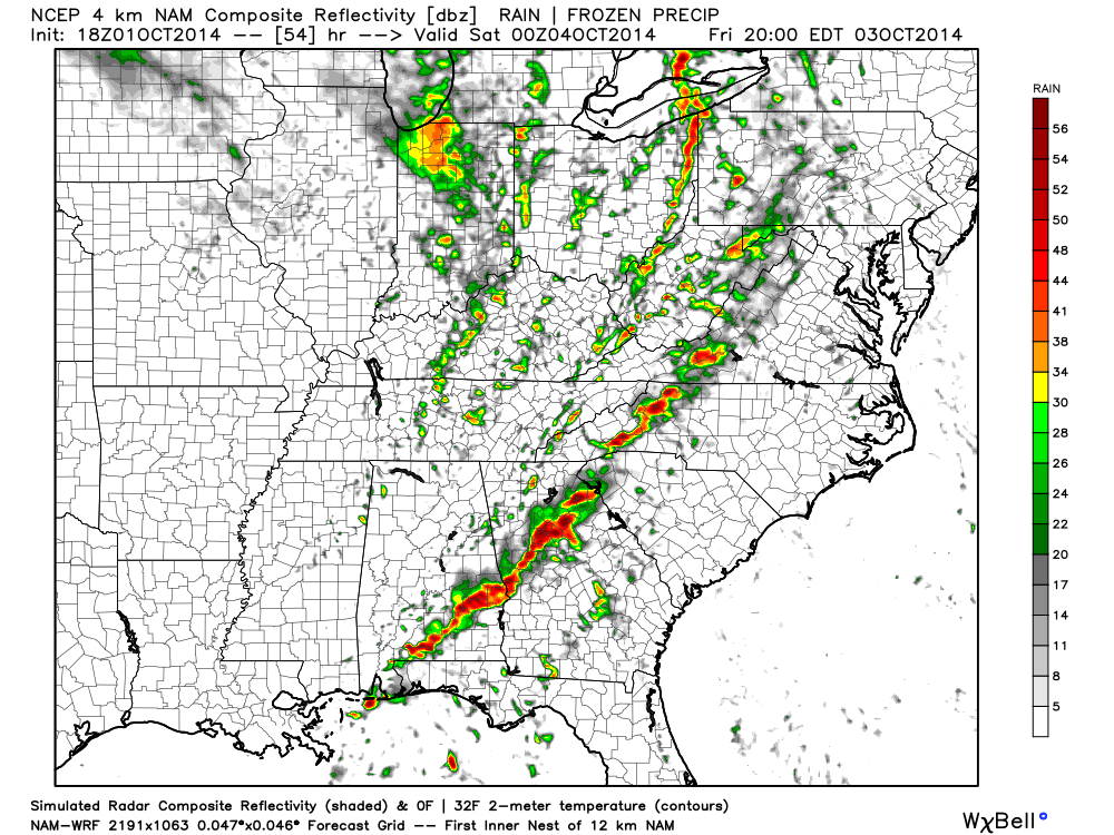
hires_ref_ky_55

Rainfall totals should reach between 1″-2″ with locally heavier amounts between the period of Thursday morning and Saturday morning.

hires_t_precip_indy_20

The rain and gusty storms will fall ahead of a strong autumn cold front that will send temperatures on a rapid downward trend come Friday night.  A deep trough will carve itself out over the eastern region Saturday and ultimately have temperatures all the way to the Gulf Coast feeling November-ish by Saturday (perfect football weather, IMO).

By the way, the record low max will be in jeopardy Saturday (49 degrees, courtesy of Sean Ash) as many central Indiana communities may struggle to make it out of the 40s for highs with considerable cloudiness, pesky drizzle, and gusty winds.  Have the jackets and sweaters ready, friends!

gfs_namer_072_500_vort_ht_s


gfs_t2m_min_east_39

Cooler Today, But A Bigger Cool Shot Arrives Friday…

Tue.

Wed.

Thr.

Fri.

Sat.

Sun.

Mon.

 Status-weather-clouds-icon

 Status-weather-clouds-icon

 Status-weather-showers-day-icon

 Status-weather-showers-day-icon

 Status-weather-clouds-icon

 Status-weather-clouds-icon

 Status-weather-showers-day-icon

56/ 70

46/ 73

58/ 82

52/ 68

44/ 55

41/ 59

49/ 69 

Cooler Today And Not As Bright…The plentiful sunshine and warm temperatures we’ve enjoyed for the past 7 days+ will shift towards a more unsettled time of things in the days ahead.  Today is just the beginning of a 1-2 punch of cooler air impacting the region.  A cold front is moving through central Indiana this morning and will result in more cloudiness today (late day brightening expected) along with a north wind shift and cooler conditions.  Lows tonight will fall into the 40s for most central Indiana communities.  Wednesday will be delightful- lots of sunshine and seasonable early autumn air.

Strong Cold Front Blasts Through…We’ll cloud things back up through the day Thursday and introduce showers and thunderstorms into your forecast Thursday night into Friday.  A couple of gusty thunderstorms are possible as the front moves through.  MUCH cooler air will pour into the area Friday afternoon and evening on gusty northwest winds.

Chilly Weekend Setting Up…The weekend will certainly require those long sleeve shirts and jackets as a MUCH cooler autumn air mass settles over the Mid West and Ohio Valley region.  Most of Saturday will likely feature mostly cloudy skies, gusty northwest winds, and sprinkles before late day clearing begins.  Note the unseasonable chill in place- only middle 50s Saturday. More sunshine is expected Sunday.

Upcoming 7-Day Precipitation Forecast:

  • 7-Day Rainfall Forecast: 0.50″ – 1.00″
  • 7-Day Snowfall Forecast: 0.00″

Weekly Outlook: Pleasant, But Big Changes Hit Late Week…

– What a beauty of a Sunday evening underway! Temperatures across the Ohio Valley and Mid West are running 15°-20° above where we’d expect them. The recent dry, warm stretch…

You must be logged in to view this content. Click Here to become a member of IndyWX.com for full access.  Already a member of IndyWx.com All-Access?  Log-in here.

Enjoy This Weekend; Changes Coming…

Sat.

Sun.

Mon.

Tue.

Wed.

Thr.

Fri.

 Status-weather-clouds-icon

 Status-weather-clouds-icon

 Status-weather-clouds-icon

 Status-weather-clouds-icon

 Status-weather-clouds-icon

 Status-weather-clouds-icon

 Status-weather-showers-day-icon

56/ 80

55/ 81

58/ 80

55/ 78

55/ 78

58/ 81

55/ 69 

Warm; Sun-Filled Weekend…High pressure will anchor itself over the eastern Great Lakes and remain close enough to our region to supply continued sunny skies and dry conditions.  We’ll also continue to enjoy a much warmer than normal feel of things (normal highs this time of year are in the lower 70s).  Enjoy, because this time next week will look and feel MUCH different…

On Cruise Control…No reason to waste many pixels on the early and mid week stretch.  Dry skies and warm air will be the rule up until Friday.

Strong Autumn Cold Front…A strong cold front will move into the area Friday and crash our perfect weather party.  Look for increasing clouds Thursday along with showers and thunderstorms Friday.  Temperatures will crash behind the boundary and set up a weekend that feels more like November than October.

Upcoming 7-Day Precipitation Forecast:

  • 7-Day Rainfall Forecast: 0.50″ – 0.75″
  • 7-Day Snowfall Forecast: 0.00″

Jason Burton sent in this beautiful sunrise shot from Union City Friday morning!  Thanks, Jason!

ByewOWKIEAAk0aJ

Fan of calm, warm weather?  Enjoy this weekend. A look at next weekend shows a drastically different look...
Fan of calm, warm weather? Enjoy this weekend. A look at next weekend shows a drastically different look…

Sun-Filled Forecast Continues…

Wed.

Thr.

Fri.

Sat.

Sun.

Mon.

Tue.

 Status-weather-clouds-icon

 Status-weather-clouds-icon

 Status-weather-clouds-icon

 Status-weather-clouds-icon

 Status-weather-clouds-icon

 Status-weather-showers-day-icon

 Status-weather-showers-day-icon

4675

5078

5178

5680

5782

5980

5876 

Closing Out The Work Week On A Beautiful Note…High pressure will remain in firm control of our weather as we put a wrap on the work week.  After a chilly open to the week, temperatures will moderate closer to seasonal levels today and above normal levels late week, continuing into early next week.  Lots of sunshine will remain locked into your forecast picture.

Moisture Slowly Returns…Moisture will slowly return as we progress into early next week.  Most, if not all, of Monday should be dry, but we’ll include the chance of an isolated shower.  Scattered shower chances continue Tuesday.

Upcoming 7-Day Precipitation Forecast

  • 7-Day Rainfall Forecast: 0.10″-0.25″
  • 7-Day Snowfall Forecast: 0.00″

Are you a fan of winter weather? Just for fun this morning we thought we’d show you the latest JAMSTEC seasonal forecast that’s hot off the press.  This implies plenty of “fun and games” if you’re a snow and cold fan… More details ahead as we progress deeper into fall.

ByS63lfCUAEA5I-.jpg-large