Forecast updated 10.03.13 @ 7:32a
Zionsville, IN It sure is hard to believe we’re in early October. Multiple days with dew points running at summer-like levels, along with temperatures a solid 10 degrees above normal will continue as we wrap up the work week. We discuss rain/ storm chances below. Even this morning there are considerable differences between the European and GFS, in particular.

Today: Scattered showers- 0.20″; 66/ 81
We think considerable cloudiness dominates the central Indiana landscape with scattered showers. Rainfall amounts will be light for most and certainly much less than the aggressive European model suggested earlier in the week. We’ll sum today up as Mostly cloudy, warm, and muggy, with scattered showers. We’re not looking at all day rains by any means, but keep the rain gear handy in case a shower moves through while you’re out and about.
 Friday: Partly cloudy; 65/ 83
While we can’t completely rule out an isolated to widely scattered shower Friday, we anticipate most neighborhoods remaining dry. Warm and unseasonably humid conditions will persist as we put a wrap on another work week.
 Saturday: Partly cloudy, late night showers and t-storms- 0.40″; 66/ 82
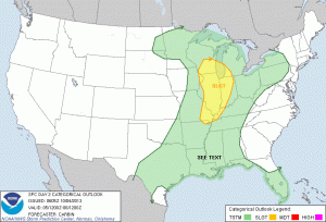
Most of your Saturday should feature nice early autumn weather conditions. In fact, it’ll feel more like summer rather than fall as gusty southwest winds help temperatures zoom into the lower 80s with a partly cloudy sky. Winds will gust upwards of 25 MPH in the open country Saturday afternoon. Otherwise, clouds will begin to increase later Saturday afternoon and showers and thunderstorms will move in Saturday night, in advance of a cold front.

Sunday: Early showers and t-storms then decreasing clouds- 0.50″; 48/ 66
After reviewing latest model data we now think most of the showers and thunderstorms fall during the first half of your Sunday with decreasing cloudiness, falling temperatures, and a distinct wind shift taking shape Sunday afternoon. That said, as mentioned to open the forecast above, considerable model differences remain between our two more powerful forecast models. Stay tuned. Once the front blows east of the region, you’ll certainly know it as a MUCH cooler and drier air mass is ushered in on winds gusting upwards of 25 MPH.
 Monday: Partly cloudy; 44/ 63
“Now this is what it’s supposed to be like!” That’s at least what this weatherman will be saying Monday. After a period of multiple days of unseasonably warm and muggy conditions, it’ll be nice to get some actual fall-like weather to enjoy as we kick off the new work week.

Tuesday: Partly cloudy; 43/ 69
I hope you liked Monday’s weather forecast, as we’ll repeat that on Tuesday- perhaps just with a touch more sunshine and moderating afternoon temperatures, after a chilly start to the day. Pumpkin spice latte anyone?

Wednesday: Partly cloudy; 49/ 74
The early take at the middle of next week shows dry skies remaining with temperatures moderating back to above normal levels.


