More On The Rain Situation, Or Lack Thereof…

Things are growing a bit dry around these parts.  Officially we’re down 3.25″ for the month and close to 5″ on the year.  (Climate information for IND: http://w2.weather.gov/climate/index.php?wfo=ind)

Rains the past (14) days have favored the central region, falling apart as the systems push east and northeast.  Texas and Oklahoma continue to make news headlines from severe flooding.  – Too much of a good thing all at once.

nws_precip_conus2_14Officially we’re not even listed in the “abnormally dry” shading, but that very well may change with the Thursday update.  Courtesy of the Regional Drought Monitor:

20150519_midwest_noneAnytime you go through May with a significant rainfall deficit it raises a concern for continued dry times going through summer.  Dry typically breeds dry this time of year, and eventually heat.  That said, a strengthening El Nino will fight the recent trend.  Around these parts weak to moderate summer El Ninos tend to yield average (to slightly above) precipitation and average (to slightly below normal) temperatures.  Recent trends, combined with longer term forecasts certainly prove to lead to a battle in the coming weeks and months…

Shorter term as we progress through the coming days, here’s how we currently assess rainfall coverage:

  • Wednesday: Scattered- favoring eastern and southern portions of the state
  • Thursday: Mostly dry
  • Friday: Widely scattered
  • Saturday: Scattered to widespread showers and thunderstorms, but many dry hours, as well.
  • Sunday: Scattered coverage

* Rainfall potential through the weekend: 0.50″-1″ for most, with locally heavier totals under stronger storms.

Strong To Severe Storms Possible Tuesday PM…

Screen Shot 2015-05-25 at 7.13.18 PMHighlights:

  • Strong to severe storms possible Tuesday afternoon/ evening
  • Drier skies Thursday-Friday
  • Weekend cold front

hires_ref_indy_28Forecast radar above (courtesy of Weatherbell.com) shows our next weather concern and that has to do with an upper air disturbance moving northeast tonight into Tuesday.  This will likely ignite scattered strong to severe thunderstorms across the area Tuesday afternoon and evening.  Remain weather-aware tomorrow for the possibility of these severe storms. Large hail is the big concern.  Should we see morning sunshine of significance then that would “up the ante” for afternoon severe potential.  We remain in a rather unsettled, warm, and humid pattern this week, but there will be plenty of dry time.  Coverage of thunderstorms Thursday and Friday will be diminished from what we can expect tomorrow and Wednesday.  A cold front will arrive over the weekend, helping to increase shower and thunderstorm coverage.

A blend of short and mid range computer guidance prints out an average of 1.5″-2″ of rain over the upcoming ten days.  This is needed after what’s been several weeks in a row of a lack of widespread rains.

Great Weekend Weather Ahead…

Screen Shot 2015-05-21 at 10.40.39 PMHighlights:

  • Another chilly start
  • Lots of weekend sunshine
  • Rain chances continue to decrease for the Indy 500
  • More humid times next week

Screen Shot 2015-05-21 at 10.43.59 PM


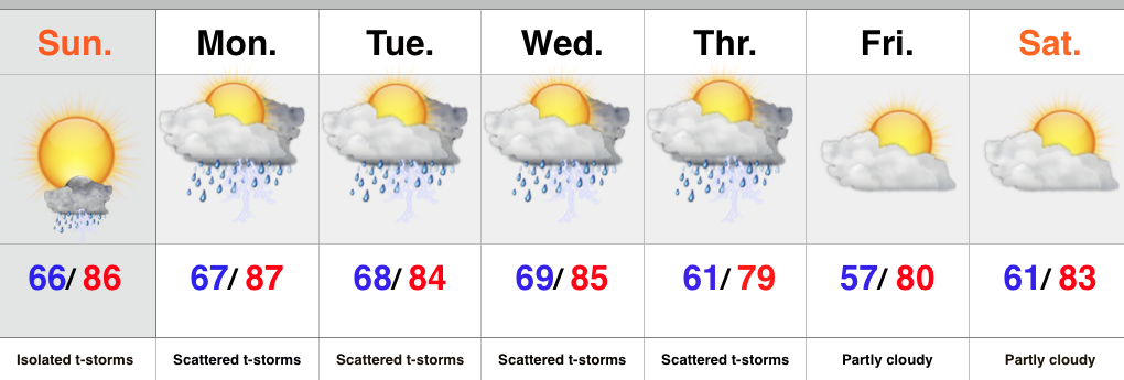
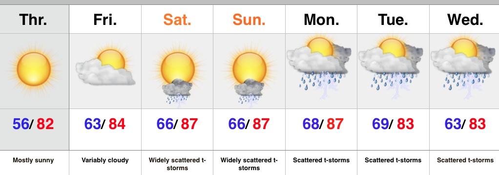
An unseasonably chilly air mass continues to engulf much of the region (shown above).  As we flip the page and head into the long holiday weekend, we’ll note moderating temperatures and increasing humidity levels once to race day.  An isolated or widely scattered storm is possible Sunday, but rainfall coverage continues to diminish with each passing computer model run.  Even if we do see a passing storm Sunday, it’ll likely arrive later in the evening.  A more humid regime will build in here next week and we’ll keep mention of showers and thunderstorms, particularly during the afternoon and evening.  We’ll highlight Tuesday and Wednesday as days with potentially the most widespread coverage of showers and storms.

Chilly Now; Continuing To Keep A Close Eye On Sunday…

Temperatures are more remenesant of early fall than late May and a stark contrast to the humid 70s to near 80 Monday. As we type this note both the 24…

You must be logged in to view this content. Click Here to become a member of IndyWX.com for full access.  Already a member of IndyWx.com All-Access?  Log-in here.

Much Cooler Air Coming…

Screen Shot 2015-05-18 at 7.35.41 AMHighlights:

  • Spotty shower or storm today
  • Much cooler Tuesday-Thursday
  • Light rain chances Wednesday
  • Keeping a close eye on Race Day/ Memorial Day wknd

A cold front still sits to our west and as the front passes through the region later this evening, an isolated or widely scattered thunderstorm will be possible, with best chances across the southeast portion of the state.  A much cooler air mass will then filter into the region for mid and late week.  A weakening disturbance may hold together just long enough to deliver some light rain Wednesday.  With added cloudiness and moisture, temperatures may not even make it out of the 50s for highs Wednesday.  Our next chance of rain will arrive Sunday, but this doesn’t appear to be any sort of significant event at this juncture- just a scattered afternoon shower or storm chance at this point.  We’ll keep a close eye on things.

1A cold front will move through the region this evening and this could spark a thunderstorm, particularly across southeastern IN.

2Our next chance of rain arrives Wednesday.  Factor in increased cloudiness and the unseasonably cool air mass in place and you have the makings for a rather cool, raw day.