One More Mild Day; Old Man Winter Is Knocking On The Door…
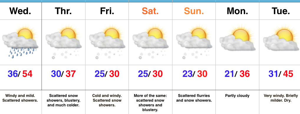
Screen Shot 2017-01-24 at 9.49.46 PMHighlights:

  • Hold on to your hats
  • Cold air returns
  • Extended period of scattered snow showers; squall potential

Changes Brewing…Wednesday will feature more of the same mild weather we’ve come to know and enjoy across the Mid West over the past couple of weeks.  Despite the mild air, a storm system will result in scattered showers for our hump day, along with very windy conditions.  Gusts of 40 MPH will be common across central IN.

Temperatures will fall late Wednesday and Old Man Winter is set to make up for lost time as we progress through the back half of the work week and on into the weekend.  In addition, fast-moving upper level energy will push southeast in the active northwest flow aloft.  Scattered snow showers will result, along with localized embedded heavier squalls.  It certainly won’t snow the entire time, but passing snow showers will be a good bet from time to time Thursday through Sunday.

Our wintry pattern will relax briefly early next week, but renewed cold air appears poised to blow into town the middle of next week.

Upcoming 7-Day Precipitation Forecast:

  • Snowfall: Dusting – 1″ (local 2″ amounts possible)
  • Rainfall: 0.10″ – 0.25″

Foggy Start; Winter Returns…

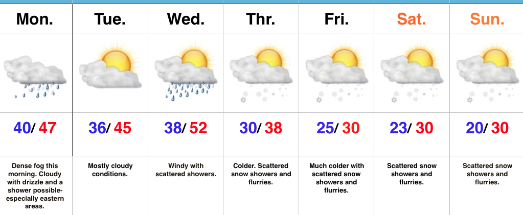
Screen Shot 2017-01-23 at 7.15.25 AMHighlights:

  • Dense fog this morning
  • Turning much colder this week
  • Scattered snow showers late week

Low Beams On…Dense fog engulfs most of central IN this morning.  Make sure you have the low beams on this morning as you head off to work and school and allow extra time.  A shower is possible at any point today, but particularly across the eastern half of the state.

Our next storm system will push through mid week.  Southwest winds will increase Wednesday and scattered showers will accompany a cold front moving through the state.  Temperatures will fall Wednesday night into Thursday and scattered snow showers will develop.

The theme late in the week and for the weekend will be a wintry one.  Upper level energy will interact with the colder conditions and result in scattered snow showers from time to time into the weekend.  The active northwest flow will remain into next week, as well, and we’ll have to keep a close eye for the prospects of a more “robust” clipper impacting the region just beyond this forecast period.

Upcoming 7-Day Precipitation Forecast:

  • Snowfall: Dusting – 1″
  • Rainfall: 0.10″ – 0.25″

Spring-Like Weekend, But Changes Loom…

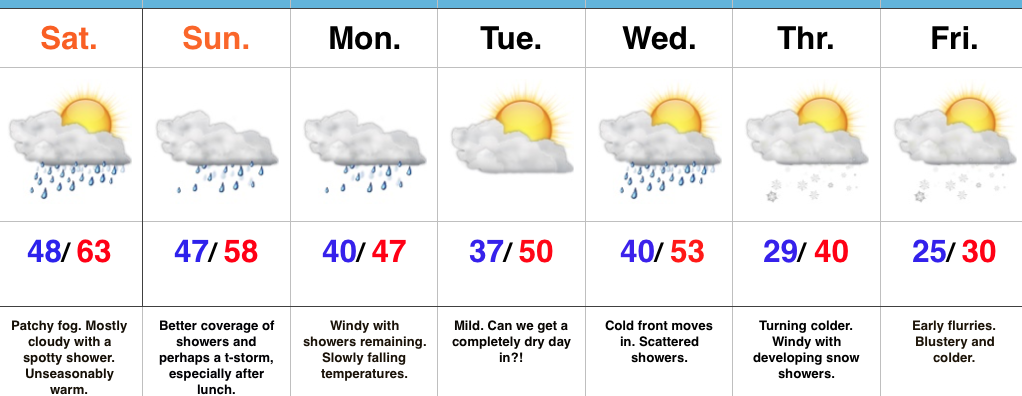
Screen Shot 2017-01-20 at 10.25.29 PMHighlights:

  • Spring-like weekend
  • Unsettled times continue
  • Winter returns

Rare January White Leg Alert…The big news this weekend will be temperatures close to 30 degrees above normal and a legitimate spring feel.  Average highs across central IN this time of year are in the middle 30s and temperatures this afternoon will zoom to the lower-middle 60s.  Patchy morning fog and drizzle will be with us, but we’re remaining optimistic we could squeeze a couple of looks at the sun during the day.  Count yourself lucky if you do, indeed, see that weird giant bright thing in the sky! 😉

A developing storm system will track east across the central Plains and into the TN Valley this weekend.  This will result in a significant severe weather outbreak across the south and increasing rain chances here for the back half of the weekend.  The magnitude of the rain and potential embedded storms remains in question, but shower chances will at least be on the increase Sunday afternoon into the evening.  We note short-term, higher resolution modeling hitting the locally heavy rain threat harder than global data early this morning (centered on Sunday evening) and we’ll keep a close eye on things as most central IN communities remain waterlogged.  Winds will increase Monday- NE shifting to the N and gusts to 40 MPH with leftover showers continuing.

Tuesday will present a bit of a break in our active pattern before a fast-moving cold front blows into town Wednesday with scattered showers amidst blustery conditions.

We turn colder (you knew this incredibly mild pattern had to break at some point) late week and upper level energy will help ignite snow showers with the return of the wintry feel Thursday into Friday.

Upcoming 7-Day Precipitation Forecast:

  • Snowfall: Dusting – 1″
  • Rainfall: 0.50″ – 0.75″

January Thaw For The New Week Ahead…

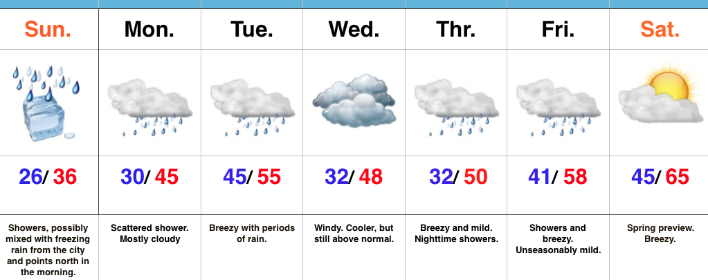
Screen Shot 2017-01-14 at 4.13.32 PMHighlights:

  • Damp, chilly Sunday
  • Milder week ahead
  • Spring-preview late next week

Improvements Coming…Most of tonight will feature dry conditions along with temperatures settling back below freezing (most of central IN will fall into the middle to upper 20s).  Another surge of light precipitation will arrive Sunday morning into the afternoon and this could begin as a period of freezing rain from the city and points north.  Similar to today, we don’t expect any major problems from the freezing rain and all of the region should warm above freezing during the afternoon.

While Monday could feature a quick-hitting shower at any given time, more widespread steady rain will push into central Indiana during the day Tuesday, along with breezy conditions.  Those breezy southwest winds will help give temperatures a boost into the middle 50s for afternoon highs.

We’ll shift that southwest wind around to the northwest Wednesday and this will help push cooler air into the state for mid week.  Despite the cooler feel, we’ll remain well above average with breezy conditions.  (Average highs in central Indiana are in the middle 30s this time of year).

The big news for the latter portion of the forecast period will be a true spring-like feel developing as we rumble into the weekend.  In fact, temperatures will surge well into the 60s next Saturday.  Modeling isn’t in total agreement on rain chances with a moist southwest flow in place.  We’ll take the “optimistic” route at this time and forecast a dry Saturday, understanding that we’ll have to maintain a close eye on things.

Quick heads up, longer term data continues to suggest we’ll flip into a much colder and stormy pattern as we wrap up January and head into February.  Winter is far from over…

Upcoming 7-Day Precipitation Forecast:

  • Snowfall: 0.00″
  • Rainfall: 0.50″ – 1.00″

Saturday Morning Freezing Rain Update…

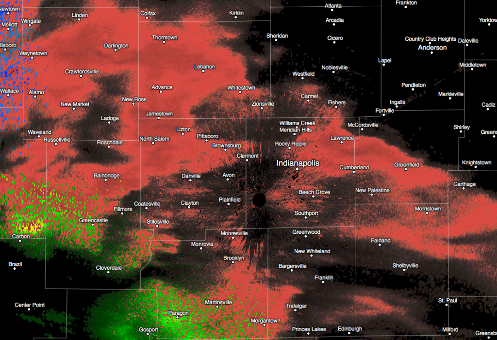
More widespread precipitation is spreading across central Indiana this morning.  Most of this precipitation is falling as freezing rain.

Radar at 7:19a.
Radar at 7:19a.

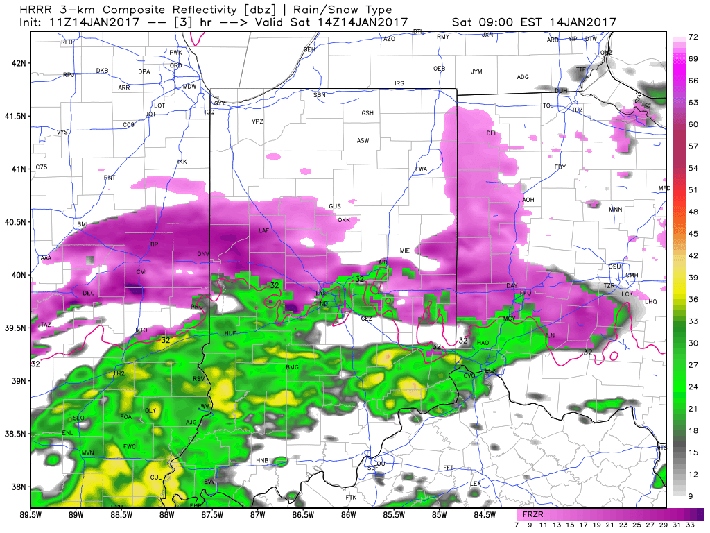
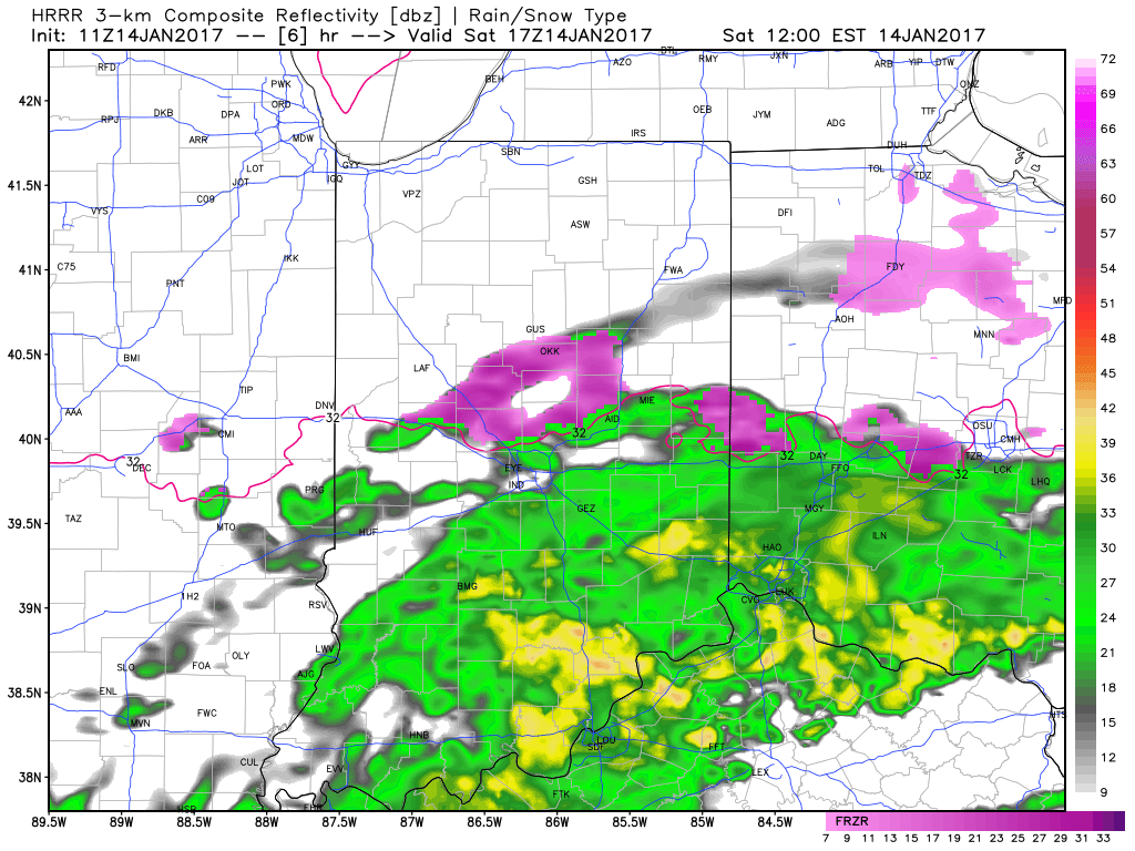
Modeled forecast radar continues to show moisture streaming across the region through around the lunchtime hour before diminishing.

9a forecast radar
9a forecast radar
12p forecast radar
12p forecast radar

Temperatures will remain around 30-32 degrees along and north of the I-70 corridor as this rain falls so it’ll freeze on contact.  Allow extra time if you must travel and slow down.  Due to our phenomenal road crews and marginally cold temperatures, we don’t expect major travel issues this morning, but do use caution if traveling.  A light glaze of ice (around 0.10″) is possible on elevated surfaces, including tree limbs and power lines.

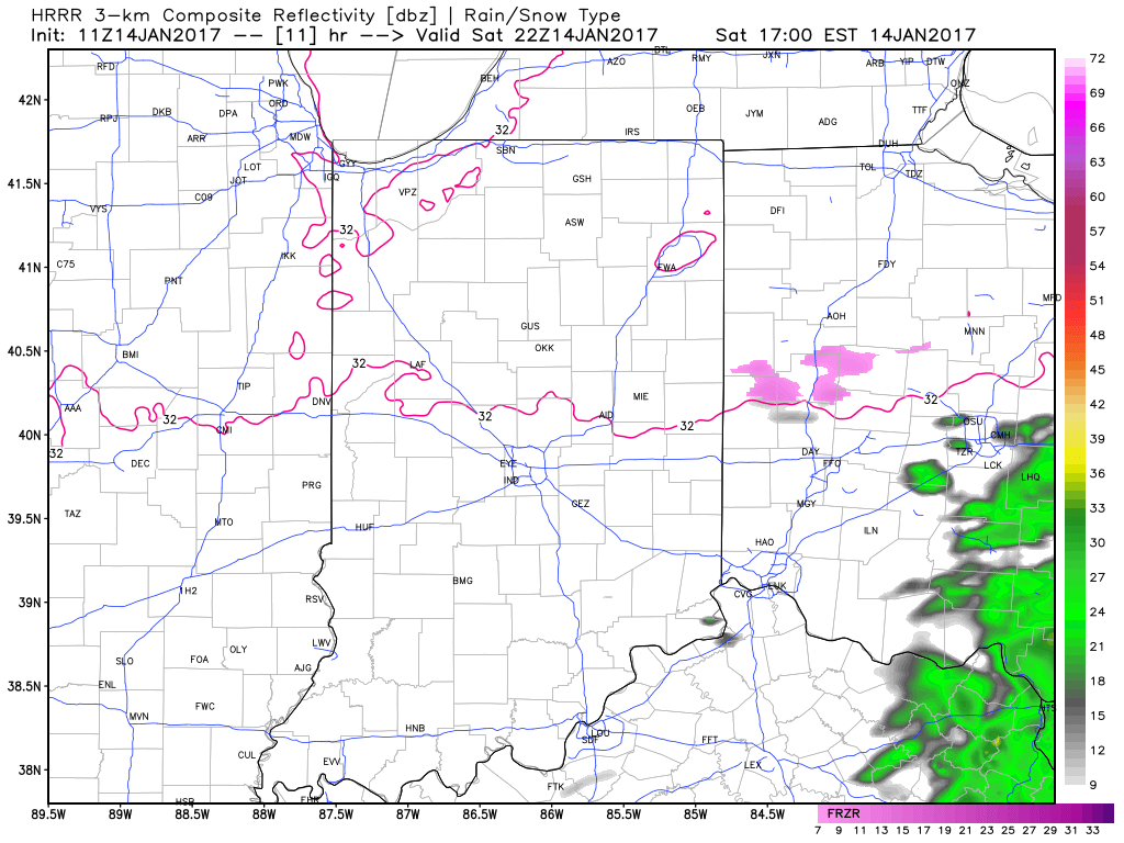
Temperatures will go above freezing this afternoon across most of central Indiana and precipitation will end.  Highs both today and Sunday should top out in the middle 30s across the region.

5p forecast radar
5p forecast radar

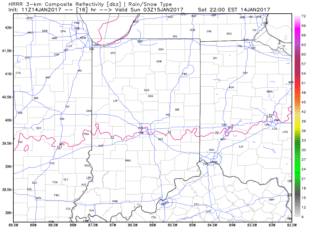
Lows tonight will settle back down into the middle to upper 20s, but dry conditions should remain for most of the night.

10p forecast radar
10p forecast radar

Our next round of precipitation looks slated for a Sunday morning arrival and, similar to this morning, this precipitation will likely fall as a mixture of light rain and light freezing rain.

Updated 7-day out later!  Have a great Saturday!