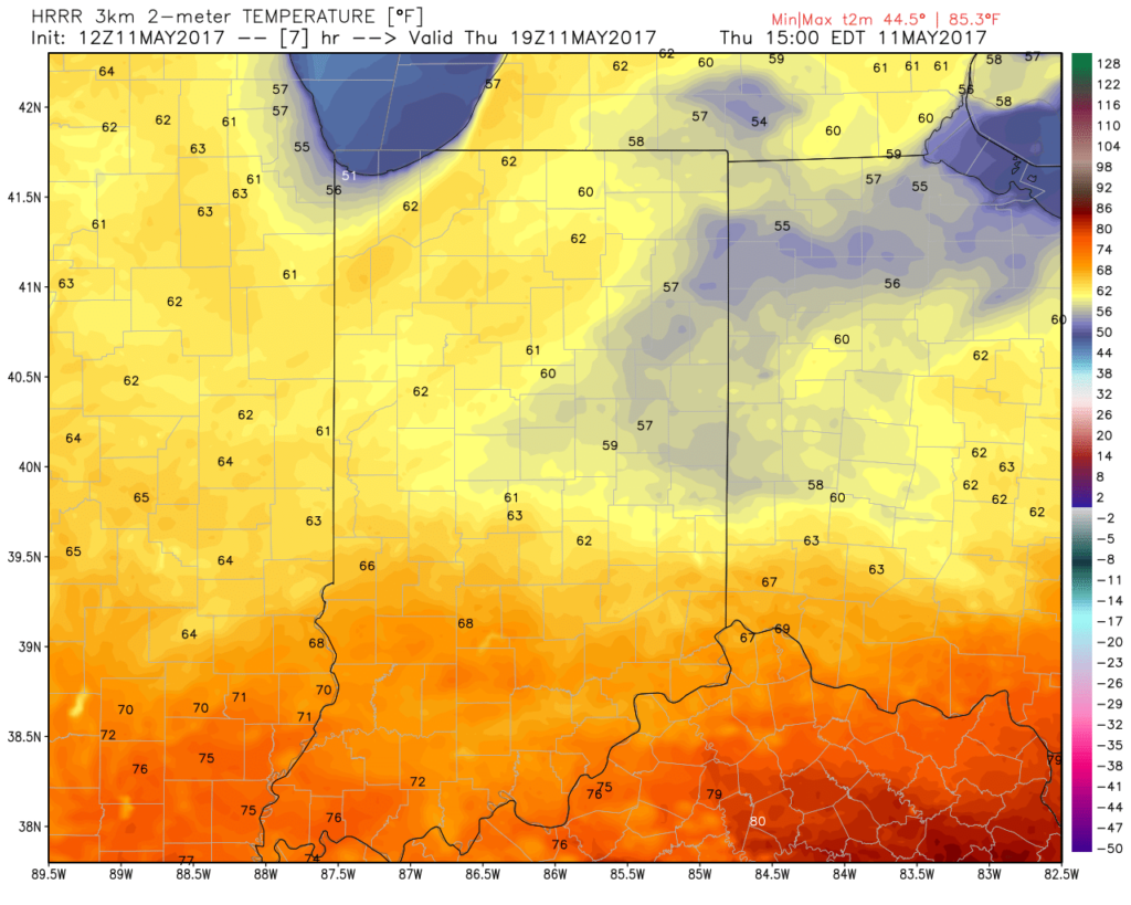
A cold front will settle south today and lead to quite the temperature gradient across the state. Cooler north breezes will result in slowly falling or steady temperatures across the northern half of the state (upper 50s to lower 60s), while southern portions of Indiana rise into the lower and middle 70s this afternoon.
A new batch of showers will ride east and impact areas mainly along and south of I-70 as we move into late morning and early afternoon. While some embedded thunder is possible, severe weather isn’t expected today.
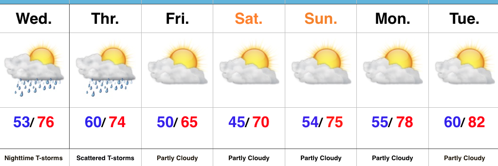
Drier and cooler air wins out for all tonight and paves way for a gorgeous weekend ahead. High pressure will support plentiful sunshine and comfortable conditions. More on the weekend and next week’s weather later today in an updated 7-day!
Nice Day Before Storm Chances Ramp Up Tonight…Once we get rid of the patchy fog this morning, a good deal of sunshine can be expected today before our next chance of storms. Better rain and storm chances will arrive tonight, especially north of the city. Locally heavy rain and a strong thunderstorm, or two, can be expected.
Scattered thunderstorms will continue Thursday morning before slowly settling south as we progress into the afternoon hours. This drier trend to end Thursday will be a prelude to the weekend. High pressure will build overhead and supply plentiful sunshine over Mother’s Day weekend, along with warmer temperatures. All-in-all, a well deserved, beautiful weekend awaits.
Dry, warm conditions will continue into early next week.
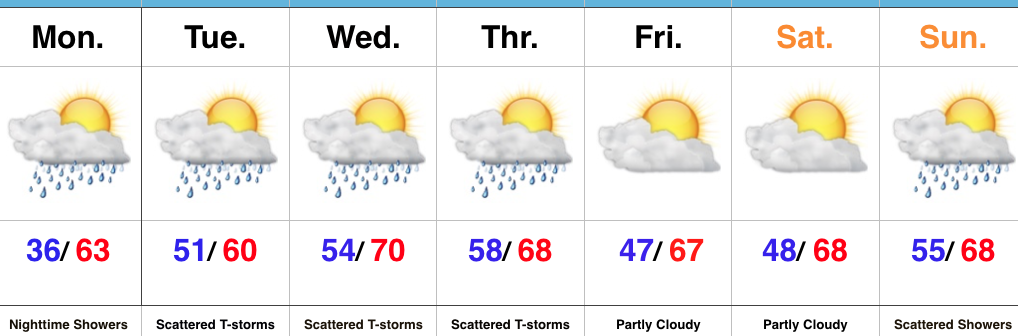
Wet Weather Returns…Bright and sunny conditions are in place as we open up a new work week, and many are awaking to frost out the door this morning, as well. Light winds, dry air, and clear skies allowed temperatures to plummet into the lower and middle 30s for many central and northeast IN neighborhoods overnight.
Clouds will increase later today and showers will arrive tonight. We’ll introduce thunderstorms into the mix Tuesday as a frontal boundary begins to settle south. That frontal boundary will begin to stall near the region midweek and additional waves of showers and thunderstorms will impact the region (especially the southern half of the state) through Thursday.
Drier weather will return to close the week and we expect a very pleasant start to the weekend.
A new weather maker will deliver a shower chance Sunday.
After a blustery and chilly Saturday (and temperatures in the upper 30s to start our Sunday), a gorgeous close to the weekend is ahead. Wall-to-wall sunshine is expected with moderating temperatures this afternoon. Our average high on the 23rd of April is 66° and we should be very close to that later this afternoon. Enjoy!
High pressure will remain entrenched over our area as we progress through the early portions of the work week. This will provide pleasant weather and plentiful sunshine. With a dry airmass in place, expect significant temperature swings. Overnight lows in the 40s will quickly rise into the 70s Monday and Tuesday.
High pressure will dominate our early-week weather.
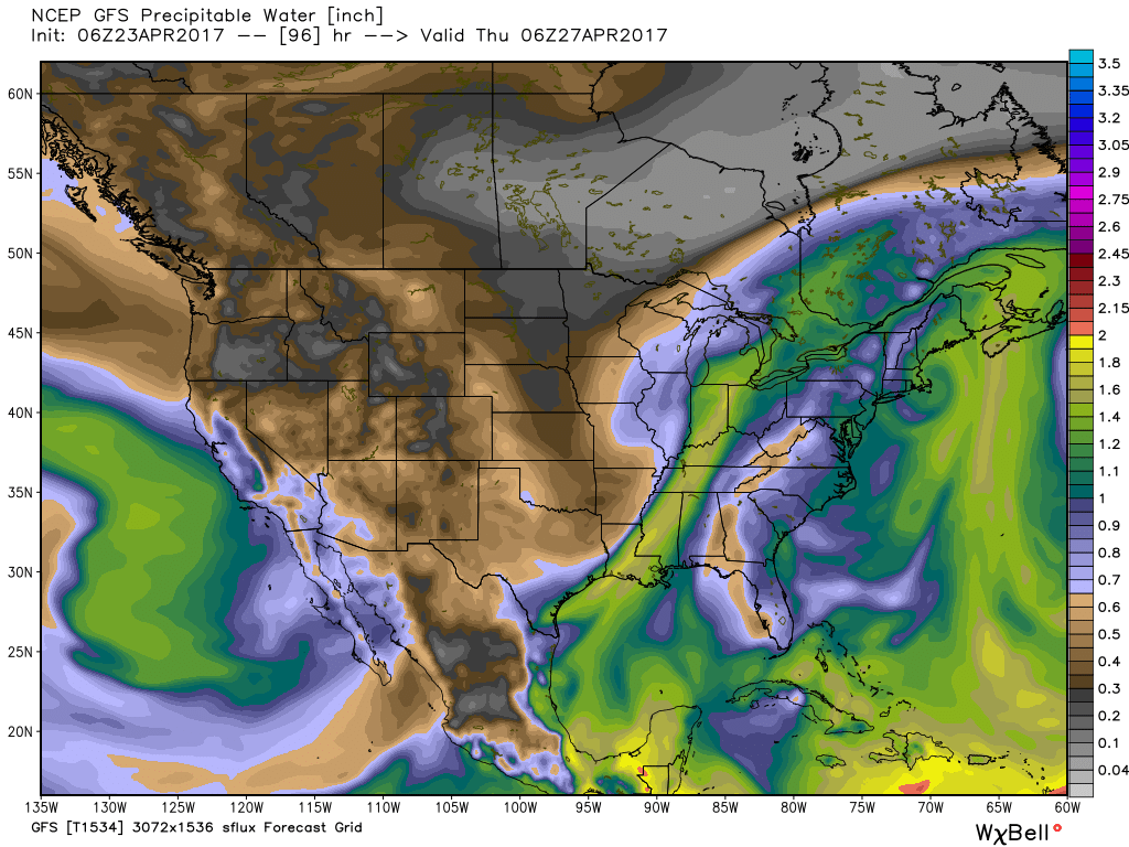
A southerly flow will help pull a more humid air mass northward Wednesday and as a cold front slices into the unseasonably warm and muggy airmass, we expect showers and thunderstorms to increase Wednesday evening into Thursday morning. We still have some time to watch things evolve, but from this distance, we feel strong to severe thunderstorm potential is present during this period. Locally heavy rains are also possible as PWATs zoom to 1.5″ +.
Precipitable water values will increase to 1.5″+ Wednesday and support the threat of locally heavy rain.
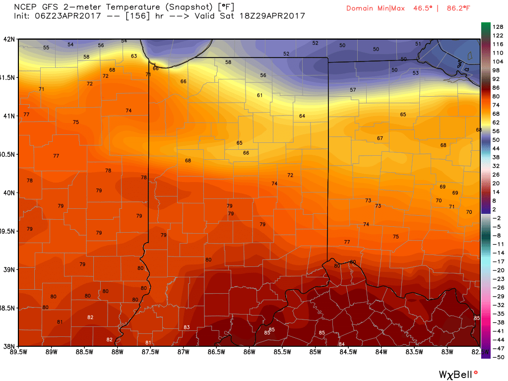
We’ll get into some briefly drier air to wrap up the work week, but a warm front will blow through the region Saturday and will likely be accompanied by thunderstorms as it lifts north. Once the warm front passes, unseasonably warm and humid air will make a return and set the stage for a true summer-like feel next weekend. We expect highs to go into the lower to middle 80s with a muggy feel, as well.
Finally, after Saturday morning thunder, we think the majority of next weekend is dry before a cold front brings a return to widespread showers and thunderstorms late Sunday.
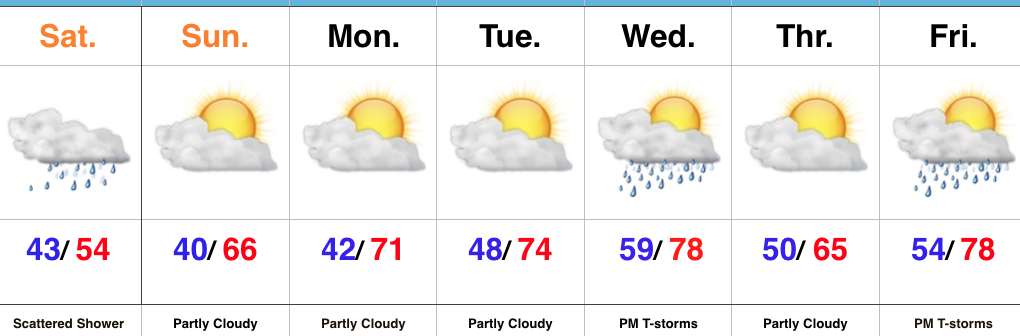
Jackets Required Today, But Improving Weather Tomorrow…A stiff northeast wind is “eating away” at the northern extent of rain today. Steadiest rains will fall across the southern third of the state, but a couple of showers may make it as far north as Indianapolis later this afternoon. The bigger story will easily be the brisk northeast flow and unseasonably chilly air. In fact, we’re waking up to wind chills in the 30s this morning. Jackets are required today.
Drier air arrives on the scene tonight and clouds will decrease overnight, paving way for a beautiful Sunday. Expect plentiful sunshine and moderating temperatures. Dry and pleasant weather continues into midweek before an approaching cold front delivers our next chance of thunderstorms Wednesday evening.
Another fast-moving weather maker will deliver thunderstorm chances to close the work week.
 A new batch of showers will ride east and impact areas mainly along and south of I-70 as we move into late morning and early afternoon. While some embedded thunder is possible, severe weather isn’t expected today.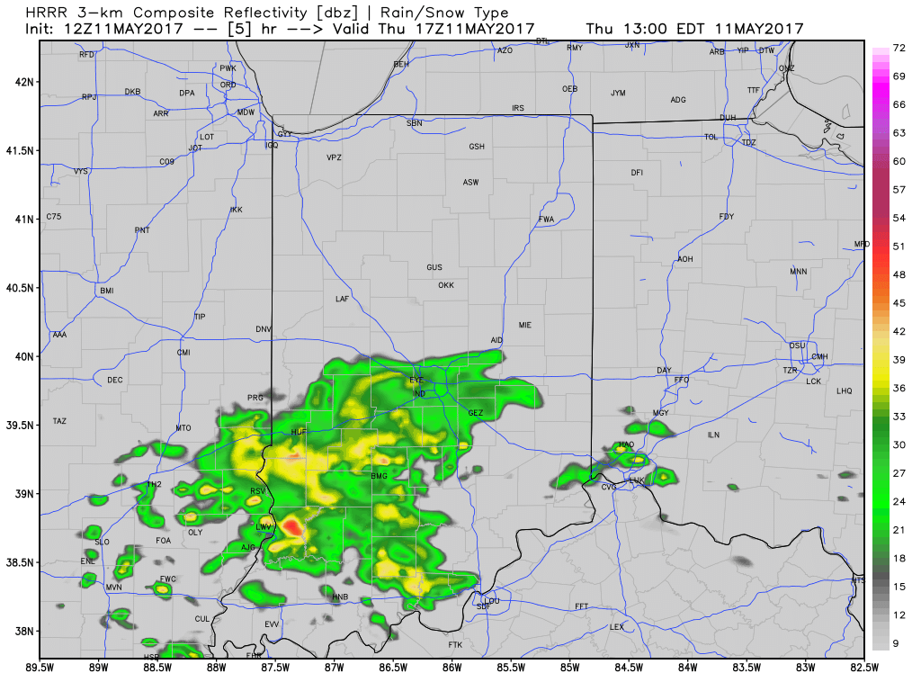
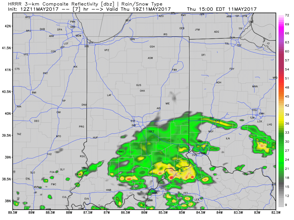 Drier and cooler air wins out for all tonight and paves way for a gorgeous weekend ahead. High pressure will support plentiful sunshine and comfortable conditions. More on the weekend and next week’s weather later today in an updated 7-day!
 Highlights:
 Highlights:

 Finally, after Saturday morning thunder, we think the majority of next weekend is dry before a cold front brings a return to widespread showers and thunderstorms late Sunday.
 Highlights: