Busy, Busy, Busy…
 Highlights:
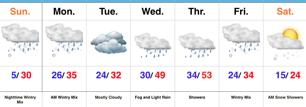
- Messy wintry mix arrives tonight
- Briefly milder midweek
- Potential storm brewing Friday
Snow And Ice Arrive Tonight…Clouds will lower and thicken across the state as we progress through the day. We’ll also note a stiff easterly breeze as an approaching storm system inches ever so much closer. This storm system will spread a wintry mix through the state tonight into early Monday morning. Initially, we think most of central Indiana will deal with snow before a transition to freezing rain during the overnight, continuing into Monday morning. Before the transition, 1″ to 2″ of snow seems to be the best idea before an icy glaze develops atop the freshly fallen snow. Based on the expected transition to freezing rain, there’s an opportunity for up to a tenth of an inch of freezing rain. That said, we’ll have to keep a very close eye on temperature profiles this evening as even the difference of a couple of degrees aloft can make all the difference in a faster or slower transition to freezing rain. Expect the Monday morning commute to be heavily impacted.
Colder air will push back in here Monday evening into Tuesday with considerable cloudiness remaining. A milder southerly flow will overtake the region Wednesday into Thursday. Low clouds and fog along with drizzle will develop Wednesday and we may have to deal with a touch of freezing drizzle early in the day before temperatures rise. A spike in temperatures will take place Thursday, briefly sending central Indiana into the 50s before a cold front slides through the state Thursday evening.
An area of low pressure will develop along the southern end of the frontal boundary and lift northeast into the TN Valley and eastern Ohio Valley Friday. As colder air presses into the region, precipitation will change from a wintry mix of sleet and freezing rain to all snow through the day Friday. It’s far too early to get specifics around accumulation ideas, but this storm has potential to be significant. Much colder air will whip in here next weekend.
Upcoming 7-Day Precipitation Forecast:
- Snowfall: 2″ – 4″
- Rainfall: 0.50″ – 0.75″
 Highlights:
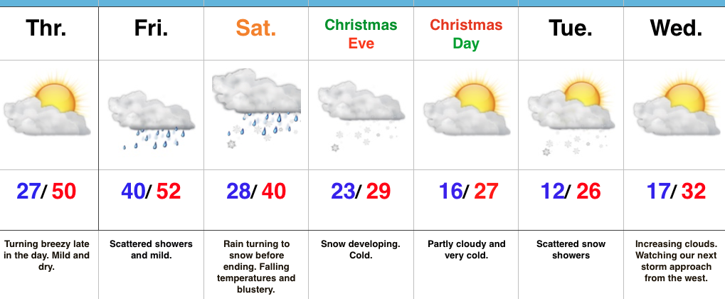 Highlights:
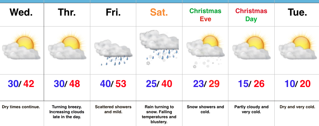 Highlights: